Westhagen elevation
Westhagen (Lower Saxony), Germany elevation is 110 meters and Westhagen elevation in feet is 361 ft above sea level [src 1]. Westhagen is a section of populated place (feature code) with elevation that is 148 meters (486 ft) smaller than average city elevation in Germany.
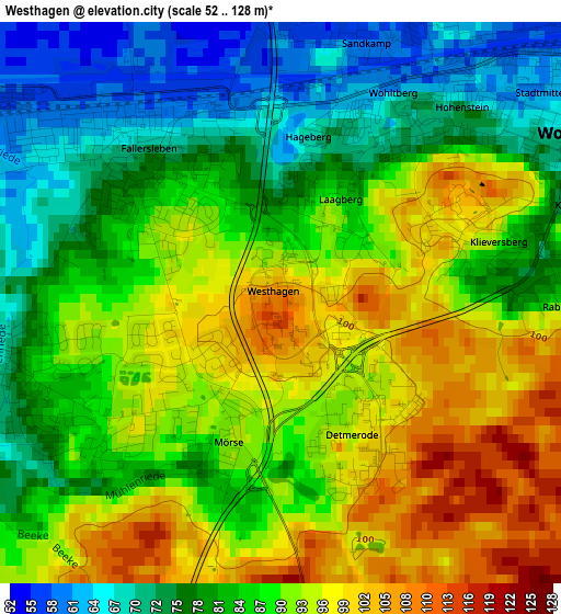
Below is the Elevation map of Westhagen, which displays elevation range with different colors. Scale of the first map is from 52 to 128 m (171 to 420 ft) with average elevation of 86.7 meters (=284 ft) [note 1]
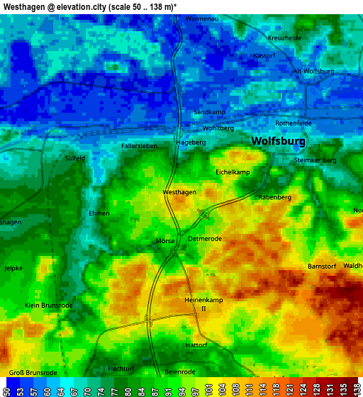
These maps also provides idea of topography and contour of this city, they are displayed at different zoom levels. More info about maps, scale and edge coordinates you can find below images.
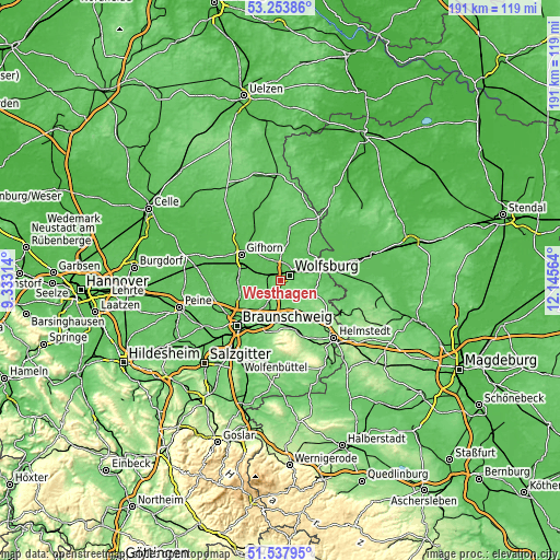
| \ | Map #1 | Map #2 | Topo.Map |
| Scale [m] | 52..128 m | 50..138 m | × |
| Scale [ft] | 171..420 ft | 164..453 ft | × |
| Average | 86.7 m = 284 ft | 81.9 m = 269 ft | × |
| Width | 5.96 km = 3.7 mi | 11.92 km = 7.4 mi | 190.8 km = 118.6 mi |
| Height | 5.96 km = 3.7 mi | 11.92 km = 7.4 mi | 190.8 km = 118.6 mi |
| ↑Max Latitude | 52.431052° | 52.457838° | 53.25386° |
| Latitude at center | 52.40425° | 52.40425° | 52.40425° |
| ↓Min Latitude | 52.377431° | 52.350597° | 51.53795° |
| ← Min Longitude | 10.695445° | 10.651499° | 9.33314° |
| Longitude center | 10.73939° | 10.73939° | 10.73939° |
| →Max Longitude | 10.783335° | 10.827281° | 12.14564° |
Nearby cities:
Cities around Westhagen sort by population:
• Wolfsburg elevation 62 m
3.6 km,  51°
51°
• Lehre 76 m
9.3 km,  212°
212°
• Detmerode 91 m
1.6 km,  166°
166°
• Isenbüttel 60 m
11.1 km,  286°
286°
• Calberlah 66 m
8.1 km,  283°
283°
• Groß Twülpstedt 101 m
12.7 km,  105°
105°
• Weyhausen 56 m
6.6 km,  346°
346°
• Danndorf 69 m
12 km,  79°
79°
• Osloß 57 m
8.3 km,  330°
330°
• Wasbüttel 68 m
9.9 km, 275°
• Jembke 63 m
10.8 km,  9°
9°
• Tappenbeck 64 m
7.4 km,  0°
0°
Multilingual:
 En español:
Westhagen elevación 110 m.
 En France:
Westhagen élévation 110 m.
 Auf Deutsch:
Westhagen höhe über dem Meeresspiegel ist 110 m.

Sources and notes:
- [note 1] Map square and city borders are not equal. Map elevation data is calculated only from area inside that square.
- [src 1] Elevation data from geonames database provided with same terms of usage.
- [src 2] The elevation map of Westhagen is generated using elevation data from NASA's 3 arcsec (90m) resolution SRTM data.
- [src 3] Base (background) map © OpenStreetMap contributors tiles are generated by Geofabrik and OpenTopoMap.
Copyright & License:
This Westhagen Elevation Map is licensed under CC BY-SA. You may reuse any part from this page, if you give a proper credit by linking to this URL:
 More info on terms of use page.