Lemförde elevation
Lemförde (Lower Saxony), Germany elevation is 43 meters and Lemförde elevation in feet is 141 ft above sea level [src 1]. Lemförde is a populated place (feature code) with elevation that is 215 meters (705 ft) smaller than average city elevation in Germany.
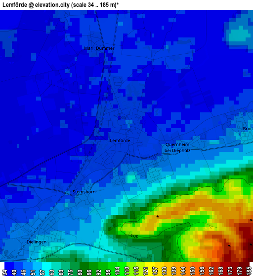
Below is the Elevation map of Lemförde, which displays elevation range with different colors. Scale of the first map is from 34 to 185 m (112 to 607 ft) with average elevation of 54.7 meters (=179 ft) [note 1]
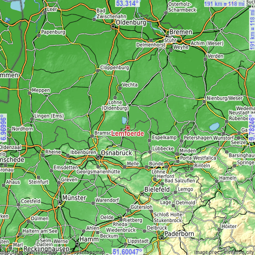
These maps also provides idea of topography and contour of this city, they are displayed at different zoom levels. More info about maps, scale and edge coordinates you can find below images.
| \ | Map #1 | Topo.Map |
| Scale [m] | 34..185 m | × |
| Scale [ft] | 112..607 ft | × |
| Average | 54.7 m = 179 ft | × |
| Width | 5.95 km = 3.7 mi | 190.5 km = 118.4 mi |
| Height | 5.95 km = 3.7 mi | 190.5 km = 118.4 mi |
| ↑Max Latitude | 52.492335° | 53.314° |
| Latitude at center | 52.46557° | 52.46557° |
| ↓Min Latitude | 52.438789° | 51.60047° |
| ← Min Longitude | 8.332265° | 6.96996° |
| Longitude center | 8.37621° | 8.37621° |
| →Max Longitude | 8.420155° | 9.78246° |
Nearby cities:
Cities around Lemförde sort by population:
• Diepholz elevation 40 m
15.8 km,  358°
358°
• Rahden 48 m
16.4 km,  102°
102°
• Damme 66 m
13.6 km,  297°
297°
• Bad Essen 132 m
16.8 km,  189°
189°
• Bohmte 66 m
11.7 km,  200°
200°
• Ostercappeln 124 m
16.1 km,  217°
217°
• Steinfeld 58 m
17.3 km,  320°
320°
• Wagenfeld 40 m
16.9 km,  56°
56°
• Laar 48 m
14.8 km,  214°
214°
• Wetschen 42 m
17.1 km,  16°
16°
• Brockum 50 m
2.7 km,  87°
87°
• Huede 42 m
3.6 km,  339°
339°
Multilingual:
 En español:
Lemförde elevación 43 m.
 En France:
Lemförde élévation 43 m.


Sources and notes:
- [note 1] Map square and city borders are not equal. Map elevation data is calculated only from area inside that square.
- [src 1] Elevation data from geonames database provided with same terms of usage.
- [src 2] The elevation map of Lemförde is generated using elevation data from NASA's 3 arcsec (90m) resolution SRTM data.
- [src 3] Base (background) map © OpenStreetMap contributors tiles are generated by Geofabrik and OpenTopoMap.
Copyright & License:
This Lemförde Elevation Map is licensed under CC BY-SA. You may reuse any part from this page, if you give a proper credit by linking to this URL:
 More info on terms of use page.