Lemgo elevation
Lemgo (North Rhine-Westphalia, Regierungsbezirk Detmold), Germany elevation is 100 meters and Lemgo elevation in feet is 328 ft above sea level [src 1]. Lemgo is a populated place (feature code) with elevation that is 158 meters (518 ft) smaller than average city elevation in Germany.
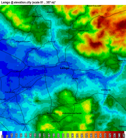
Below is the Elevation map of Lemgo, which displays elevation range with different colors. Scale of the first map is from 86 to 353 m (282 to 1158 ft) with average elevation of 135.2 meters (=444 ft) [note 1]
These maps also provides idea of topography and contour of this city, they are displayed at different zoom levels. More info about maps, scale and edge coordinates you can find below images.

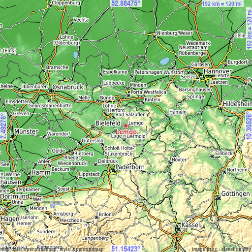
| \ | Map #1 | Map #2 | Topo.Map |
| Scale [m] | 86..353 m | 81..357 m | × |
| Scale [ft] | 282..1158 ft | 266..1171 ft | × |
| Average | 135.2 m = 444 ft | 161.6 m = 530 ft | × |
| Width | 6.01 km = 3.7 mi | 12.03 km = 7.5 mi | 192.4 km = 119.6 mi |
| Height | 6.01 km = 3.7 mi | 12.03 km = 7.5 mi | 192.4 km = 119.6 mi |
| ↑Max Latitude | 52.05489° | 52.081904° | 52.88475° |
| Latitude at center | 52.02786° | 52.02786° | 52.02786° |
| ↓Min Latitude | 52.000813° | 51.97375° | 51.15423° |
| ← Min Longitude | 8.855065° | 8.811119° | 7.49276° |
| Longitude center | 8.89901° | 8.89901° | 8.89901° |
| →Max Longitude | 8.942955° | 8.986901° | 10.30526° |
Nearby cities:
Cities around Lemgo sort by population:
• Detmold elevation 135 m
10.1 km,  190°
190°
• Bad Salzuflen 82 m
12.4 km,  301°
301°
• Lage 103 m
8.3 km,  241°
241°
• Vlotho 68 m
15.5 km,  350°
350°
• Oerlinghausen 229 m
18.1 km, 243°
• Blomberg 184 m
16.1 km,  125°
125°
• Leopoldshöhe 132 m
13.8 km,  262°
262°
• Augustdorf 169 m
17.5 km,  221°
221°
• Barntrup 196 m
15.5 km,  105°
105°
• Dörentrup 156 m
7.2 km,  78°
78°
• Horn 220 m
17.7 km,  169°
169°
• Bad Meinberg 211 m
15.8 km,  158°
158°
Multilingual:
 En español:
Lemgo elevación 100 m.
 En France:
Lemgo élévation 100 m.


Sources and notes:
- [note 1] Map square and city borders are not equal. Map elevation data is calculated only from area inside that square.
- [src 1] Elevation data from geonames database provided with same terms of usage.
- [src 2] The elevation map of Lemgo is generated using elevation data from NASA's 3 arcsec (90m) resolution SRTM data.
- [src 3] Base (background) map © OpenStreetMap contributors tiles are generated by Geofabrik and OpenTopoMap.
Copyright & License:
This Lemgo Elevation Map is licensed under CC BY-SA. You may reuse any part from this page, if you give a proper credit by linking to this URL:
 More info on terms of use page.