Mahlberg elevation
Mahlberg (Baden-Württemberg, Freiburg Region), Germany elevation is 191 meters and Mahlberg elevation in feet is 627 ft above sea level [src 1]. Mahlberg is a populated place (feature code) with elevation that is 67 meters (220 ft) smaller than average city elevation in Germany.
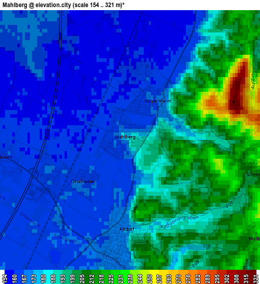
Below is the Elevation map of Mahlberg, which displays elevation range with different colors. Scale of the first map is from 154 to 321 m (505 to 1053 ft) with average elevation of 182.3 meters (=598 ft) [note 1]
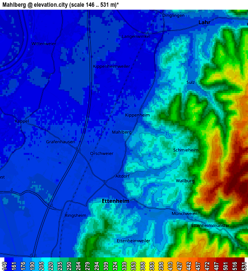
These maps also provides idea of topography and contour of this city, they are displayed at different zoom levels. More info about maps, scale and edge coordinates you can find below images.
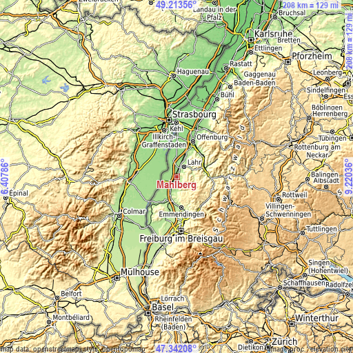
| \ | Map #1 | Map #2 | Topo.Map |
| Scale [m] | 154..321 m | 146..531 m | × |
| Scale [ft] | 505..1053 ft | 479..1742 ft | × |
| Average | 182.3 m = 598 ft | 213.1 m = 699 ft | × |
| Width | 6.5 km = 4 mi | 13.01 km = 8.1 mi | 208.1 km = 129.3 mi |
| Height | 6.5 km = 4 mi | 13.01 km = 8.1 mi | 208.1 km = 129.3 mi |
| ↑Max Latitude | 48.315623° | 48.34484° | 49.21356° |
| Latitude at center | 48.28639° | 48.28639° | 48.28639° |
| ↓Min Latitude | 48.25714° | 48.227873° | 47.34208° |
| ← Min Longitude | 7.770165° | 7.726219° | 6.40786° |
| Longitude center | 7.81411° | 7.81411° | 7.81411° |
| →Max Longitude | 7.858055° | 7.902001° | 9.22036° |
Nearby cities:
Cities around Mahlberg sort by population:
• Lahr elevation 176 m
7.2 km,  33°
33°
• Ettenheim 173 m
3.3 km,  182°
182°
• Herbolzheim 178 m
8 km,  199°
199°
• Hohberg 343 m
7.5 km,  57°
57°
• Schwanau 151 m
9.7 km,  336°
336°
• Seelbach 217 m
9.7 km,  73°
73°
• Kippenheim 169 m
1.3 km,  38°
38°
• Kappel-Grafenhausen 164 m
3.6 km,  265°
265°
• Rust 162 m
6.4 km,  249°
249°
• Schuttertal 284 m
10.3 km,  102°
102°
• Grafenhausen 166 m
3.5 km, 266°
• Ringsheim 171 m
5.1 km,  211°
211°
Multilingual:
 En español:
Mahlberg elevación 191 m.
 En France:
Mahlberg élévation 191 m.
 Auf Deutsch:
Mahlberg höhe über dem Meeresspiegel ist 191 m.

Sources and notes:
- [note 1] Map square and city borders are not equal. Map elevation data is calculated only from area inside that square.
- [src 1] Elevation data from geonames database provided with same terms of usage.
- [src 2] The elevation map of Mahlberg is generated using elevation data from NASA's 3 arcsec (90m) resolution SRTM data.
- [src 3] Base (background) map © OpenStreetMap contributors tiles are generated by Geofabrik and OpenTopoMap.
Copyright & License:
This Mahlberg Elevation Map is licensed under CC BY-SA. You may reuse any part from this page, if you give a proper credit by linking to this URL:
 More info on terms of use page.