Mainz elevation
Mainz (Rheinland-Pfalz), Germany elevation is 126 meters and Mainz elevation in feet is 413 ft above sea level [src 1]. Mainz is a seat of a first-order administrative division (feature code) with elevation that is 132 meters (433 ft) smaller than average city elevation in Germany.
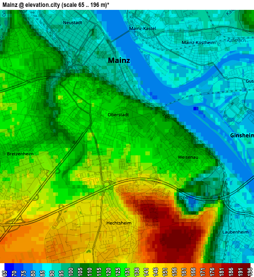
Below is the Elevation map of Mainz, which displays elevation range with different colors. Scale of the first map is from 65 to 196 m (213 to 643 ft) with average elevation of 117.6 meters (=386 ft) [note 1]
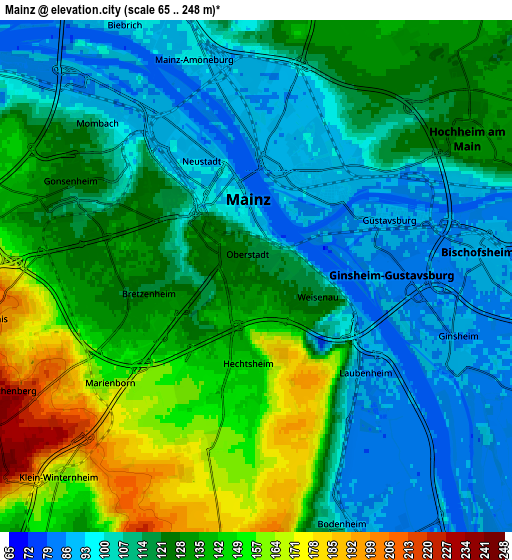
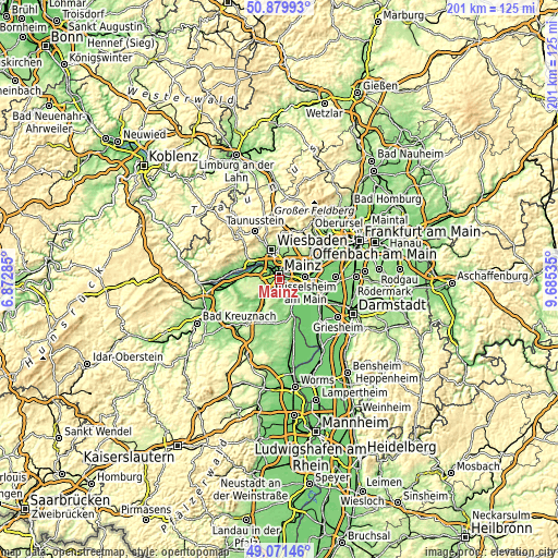
These maps also provides idea of topography and contour of this city, they are displayed at different zoom levels. More info about maps, scale and edge coordinates you can find below images.
| \ | Map #1 | Map #2 | Topo.Map |
| Scale [m] | 65..196 m | 65..248 m | × |
| Scale [ft] | 213..643 ft | 213..814 ft | × |
| Average | 117.6 m = 386 ft | 122.1 m = 401 ft | × |
| Width | 6.28 km = 3.9 mi | 12.57 km = 7.8 mi | 201.1 km = 125 mi |
| Height | 6.28 km = 3.9 mi | 12.57 km = 7.8 mi | 201.1 km = 125 mi |
| ↑Max Latitude | 50.012438° | 50.04067° | 50.87993° |
| Latitude at center | 49.98419° | 49.98419° | 49.98419° |
| ↓Min Latitude | 49.955925° | 49.927643° | 49.07146° |
| ← Min Longitude | 8.235155° | 8.191209° | 6.87285° |
| Longitude center | 8.2791° | 8.2791° | 8.2791° |
| →Max Longitude | 8.323045° | 8.366991° | 9.68535° |
Nearby cities:
Cities around Mainz sort by population:
• Hochheim am Main elevation 131 m
6.2 km,  57°
57°
• Ginsheim-Gustavsburg 85 m
5 km,  107°
107°
• Bischofsheim 86 m
6.4 km,  80°
80°
• Budenheim 105 m
8.8 km,  294°
294°
• Nieder-Olm 136 m
9.6 km,  213°
213°
• Bodenheim 86 m
6.2 km,  151°
151°
• Nackenheim 112 m
8.8 km, 150°
• Ober-Olm 221 m
8.3 km,  231°
231°
• Klein-Winternheim 156 m
7 km,  223°
223°
• Lörzweiler 144 m
9.6 km,  173°
173°
• Harxheim 159 m
8.8 km,  186°
186°
• Gau-Bischofsheim 170 m
7.6 km,  183°
183°
Multilingual:
 En español:
Maguncia elevación 126 m.
 En France:
Mayence élévation 126 m.


Sources and notes:
- [note 1] Map square and city borders are not equal. Map elevation data is calculated only from area inside that square.
- [src 1] Elevation data from geonames database provided with same terms of usage.
- [src 2] The elevation map of Mainz is generated using elevation data from NASA's 3 arcsec (90m) resolution SRTM data.
- [src 3] Base (background) map © OpenStreetMap contributors tiles are generated by Geofabrik and OpenTopoMap.
Copyright & License:
This Mainz Elevation Map is licensed under CC BY-SA. You may reuse any part from this page, if you give a proper credit by linking to this URL:
 More info on terms of use page.