Nackenheim elevation
Nackenheim (Rheinland-Pfalz), Germany elevation is 112 meters and Nackenheim elevation in feet is 367 ft above sea level [src 1]. Nackenheim is a seat of a fourth-order administrative division (feature code) with elevation that is 146 meters (479 ft) smaller than average city elevation in Germany.
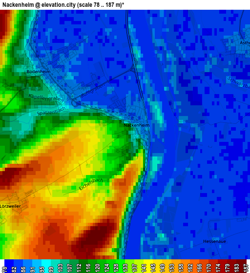
Below is the Elevation map of Nackenheim, which displays elevation range with different colors. Scale of the first map is from 78 to 187 m (256 to 614 ft) with average elevation of 106.2 meters (=348 ft) [note 1]
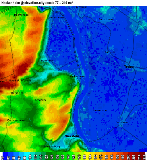
These maps also provides idea of topography and contour of this city, they are displayed at different zoom levels. More info about maps, scale and edge coordinates you can find below images.
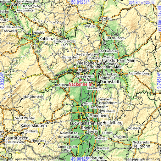
| \ | Map #1 | Map #2 | Topo.Map |
| Scale [m] | 78..187 m | 77..219 m | × |
| Scale [ft] | 256..614 ft | 253..719 ft | × |
| Average | 106.2 m = 348 ft | 114 m = 374 ft | × |
| Width | 6.29 km = 3.9 mi | 12.59 km = 7.8 mi | 201.4 km = 125.1 mi |
| Height | 6.29 km = 3.9 mi | 12.59 km = 7.8 mi | 201.4 km = 125.1 mi |
| ↑Max Latitude | 49.943569° | 49.971841° | 50.81231° |
| Latitude at center | 49.91528° | 49.91528° | 49.91528° |
| ↓Min Latitude | 49.886974° | 49.858652° | 49.00125° |
| ← Min Longitude | 8.294945° | 8.250999° | 6.93264° |
| Longitude center | 8.33889° | 8.33889° | 8.33889° |
| →Max Longitude | 8.382835° | 8.426781° | 9.74514° |
Nearby cities:
Cities around Nackenheim sort by population:
• Ginsheim-Gustavsburg elevation 85 m
6.2 km,  4°
4°
• Trebur 89 m
5.1 km,  75°
75°
• Nierstein 101 m
5 km,  181°
181°
• Bodenheim 86 m
2.6 km,  328°
328°
• Oppenheim 88 m
6.9 km,  167°
167°
• Zornheim 217 m
8.6 km,  251°
251°
• Mommenheim 152 m
6.6 km,  233°
233°
• Lörzweiler 144 m
3.7 km,  239°
239°
• Harxheim 159 m
5.5 km,  258°
258°
• Gau-Bischofsheim 170 m
4.7 km,  270°
270°
• Selzen 124 m
8.5 km,  224°
224°
• Dexheim 154 m
7.7 km,  191°
191°
Multilingual:
 En español:
Nackenheim elevación 112 m.
 En France:
Nackenheim élévation 112 m.
 Auf Deutsch:
Nackenheim höhe über dem Meeresspiegel ist 112 m.

Sources and notes:
- [note 1] Map square and city borders are not equal. Map elevation data is calculated only from area inside that square.
- [src 1] Elevation data from geonames database provided with same terms of usage.
- [src 2] The elevation map of Nackenheim is generated using elevation data from NASA's 3 arcsec (90m) resolution SRTM data.
- [src 3] Base (background) map © OpenStreetMap contributors tiles are generated by Geofabrik and OpenTopoMap.
Copyright & License:
This Nackenheim Elevation Map is licensed under CC BY-SA. You may reuse any part from this page, if you give a proper credit by linking to this URL:
 More info on terms of use page.