Trebur elevation
Trebur (Hesse, Regierungsbezirk Darmstadt), Germany elevation is 89 meters and Trebur elevation in feet is 292 ft above sea level [src 1]. Trebur is a seat of a fourth-order administrative division (feature code) with elevation that is 169 meters (554 ft) smaller than average city elevation in Germany.
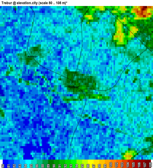
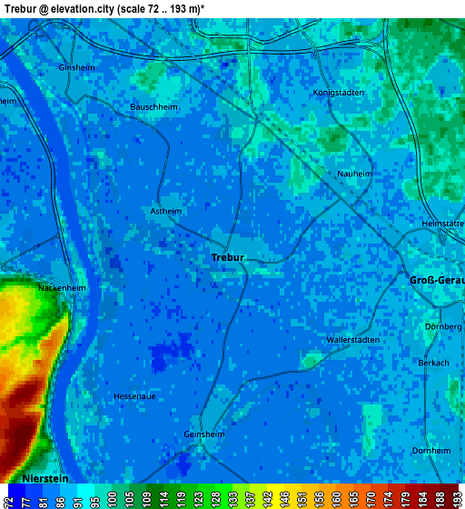
Below is the Elevation map of Trebur, which displays elevation range with different colors. Scale of the first map is from 80 to 108 m (262 to 354 ft) with average elevation of 85.1 meters (=279 ft) [note 1]
These maps also provides idea of topography and contour of this city, they are displayed at different zoom levels. More info about maps, scale and edge coordinates you can find below images.
| \ | Map #1 | Map #2 | Topo.Map |
| Scale [m] | 80..108 m | 72..193 m | × |
| Scale [ft] | 262..354 ft | 236..633 ft | × |
| Average | 85.1 m = 279 ft | 90.1 m = 296 ft | × |
| Width | 6.29 km = 3.9 mi | 12.58 km = 7.8 mi | 201.3 km = 125.1 mi |
| Height | 6.29 km = 3.9 mi | 12.58 km = 7.8 mi | 201.3 km = 125.1 mi |
| ↑Max Latitude | 49.954672° | 49.982938° | 50.82321° |
| Latitude at center | 49.92639° | 49.92639° | 49.92639° |
| ↓Min Latitude | 49.898091° | 49.869775° | 49.01257° |
| ← Min Longitude | 8.363375° | 8.319429° | 7.00107° |
| Longitude center | 8.40732° | 8.40732° | 8.40732° |
| →Max Longitude | 8.451265° | 8.495211° | 9.81357° |
Nearby cities:
Cities around Trebur sort by population:
• Rüsselsheim elevation 89 m
7.1 km,  8°
8°
• Groß-Gerau 95 m
5.4 km,  95°
95°
• Flörsheim 94 m
9.8 km, 8°
• Ginsheim-Gustavsburg 85 m
6.7 km,  318°
318°
• Büttelborn 95 m
8.7 km,  107°
107°
• Bischofsheim 86 m
8 km,  339°
339°
• Nierstein 101 m
8.1 km,  218°
218°
• Bodenheim 86 m
6.3 km,  278°
278°
• Oppenheim 88 m
8.7 km,  203°
203°
• Nackenheim 112 m
5.1 km,  255°
255°
• Lörzweiler 144 m
8.6 km,  248°
248°
• Gau-Bischofsheim 170 m
9.7 km, 263°
Multilingual:
 En español:
Trebur elevación 89 m.
 En France:
Trebur élévation 89 m.


Sources and notes:
- [note 1] Map square and city borders are not equal. Map elevation data is calculated only from area inside that square.
- [src 1] Elevation data from geonames database provided with same terms of usage.
- [src 2] The elevation map of Trebur is generated using elevation data from NASA's 3 arcsec (90m) resolution SRTM data.
- [src 3] Base (background) map © OpenStreetMap contributors tiles are generated by Geofabrik and OpenTopoMap.
Copyright & License:
This Trebur Elevation Map is licensed under CC BY-SA. You may reuse any part from this page, if you give a proper credit by linking to this URL:
 More info on terms of use page.