Marksuhl elevation
Marksuhl (Thuringia), Germany elevation is 251 meters and Marksuhl elevation in feet is 823 ft above sea level [src 1]. Marksuhl is a seat of a fourth-order administrative division (feature code) with elevation that is 7 meters (23 ft) smaller than average city elevation in Germany.
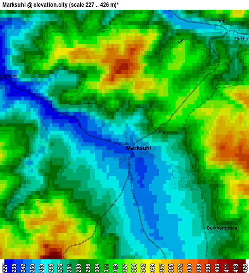
Below is the Elevation map of Marksuhl, which displays elevation range with different colors. Scale of the first map is from 227 to 426 m (745 to 1398 ft) with average elevation of 296.5 meters (=973 ft) [note 1]
These maps also provides idea of topography and contour of this city, they are displayed at different zoom levels. More info about maps, scale and edge coordinates you can find below images.
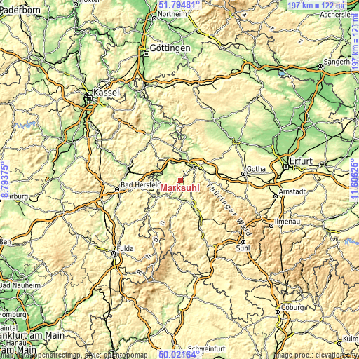
| \ | Map #1 | Topo.Map |
| Scale [m] | 227..426 m | × |
| Scale [ft] | 745..1398 ft | × |
| Average | 296.5 m = 973 ft | × |
| Width | 6.16 km = 3.8 mi | 197.2 km = 122.5 mi |
| Height | 6.16 km = 3.8 mi | 197.1 km = 122.5 mi |
| ↑Max Latitude | 50.944367° | 51.79481° |
| Latitude at center | 50.91667° | 50.91667° |
| ↓Min Latitude | 50.888956° | 50.02164° |
| ← Min Longitude | 10.156055° | 8.79375° |
| Longitude center | 10.2° | 10.2° |
| →Max Longitude | 10.243945° | 11.60625° |
Nearby cities:
Cities around Marksuhl sort by population:
• Eisenach elevation 215 m
10.8 km,  48°
48°
• Bad Salzungen 250 m
11.8 km,  167°
167°
• Ruhla 418 m
11.9 km,  102°
102°
• Tiefenort 238 m
8.9 km,  195°
195°
• Gerstungen 218 m
10.9 km,  300°
300°
• Herleshausen 219 m
10.2 km,  347°
347°
• Dorndorf 250 m
12 km,  220°
220°
• Leimbach 238 m
11.1 km,  180°
180°
• Krauthausen 242 m
12.1 km,  22°
22°
• Dankmarshausen 230 m
12.9 km,  274°
274°
• Dippach 218 m
11.1 km, 271°
• Lauchröden 205 m
9.1 km,  340°
340°
Multilingual:
 En español:
Marksuhl elevación 251 m.
 En France:
Marksuhl élévation 251 m.
 Auf Deutsch:
Marksuhl höhe über dem Meeresspiegel ist 251 m.

Sources and notes:
- [note 1] Map square and city borders are not equal. Map elevation data is calculated only from area inside that square.
- [src 1] Elevation data from geonames database provided with same terms of usage.
- [src 2] The elevation map of Marksuhl is generated using elevation data from NASA's 3 arcsec (90m) resolution SRTM data.
- [src 3] Base (background) map © OpenStreetMap contributors tiles are generated by Geofabrik and OpenTopoMap.
Copyright & License:
This Marksuhl Elevation Map is licensed under CC BY-SA. You may reuse any part from this page, if you give a proper credit by linking to this URL:
 More info on terms of use page.