Eisenach elevation
Eisenach (Thuringia), Germany elevation is 215 meters and Eisenach elevation in feet is 705 ft above sea level [src 1]. Eisenach is a populated place (feature code) with elevation that is 43 meters (141 ft) smaller than average city elevation in Germany.
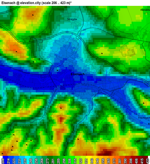
Below is the Elevation map of Eisenach, which displays elevation range with different colors. Scale of the first map is from 206 to 423 m (676 to 1388 ft) with average elevation of 281.1 meters (=922 ft) [note 1]
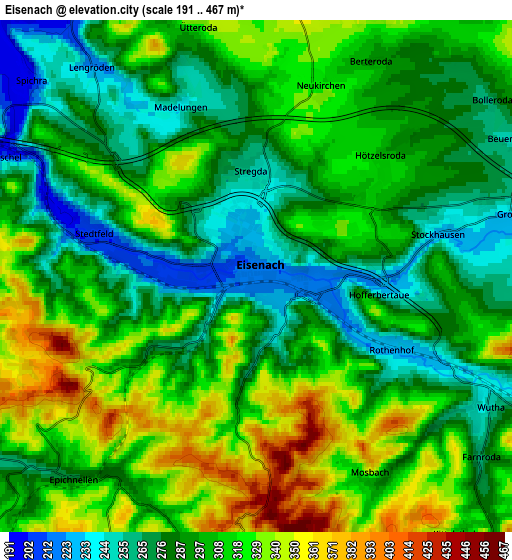
These maps also provides idea of topography and contour of this city, they are displayed at different zoom levels. More info about maps, scale and edge coordinates you can find below images.
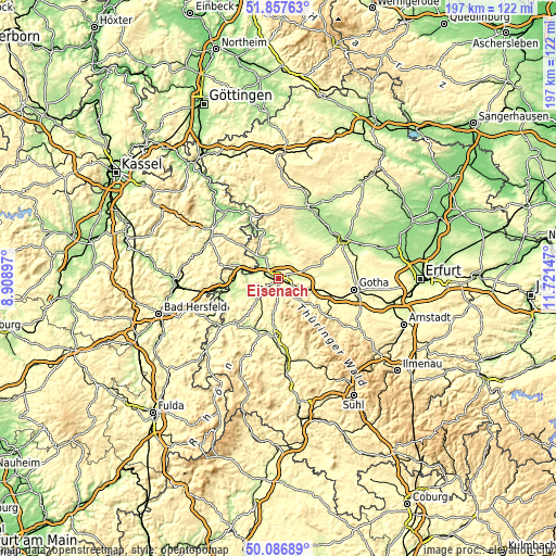
| \ | Map #1 | Map #2 | Topo.Map |
| Scale [m] | 206..423 m | 191..467 m | × |
| Scale [ft] | 676..1388 ft | 627..1532 ft | × |
| Average | 281.1 m = 922 ft | 300.9 m = 987 ft | × |
| Width | 6.15 km = 3.8 mi | 12.31 km = 7.6 mi | 196.9 km = 122.3 mi |
| Height | 6.15 km = 3.8 mi | 12.31 km = 7.6 mi | 196.9 km = 122.3 mi |
| ↑Max Latitude | 51.008359° | 51.036001° | 51.85763° |
| Latitude at center | 50.9807° | 50.9807° | 50.9807° |
| ↓Min Latitude | 50.953025° | 50.925333° | 50.08689° |
| ← Min Longitude | 10.271275° | 10.227329° | 8.90897° |
| Longitude center | 10.31522° | 10.31522° | 10.31522° |
| →Max Longitude | 10.359165° | 10.403111° | 11.72147° |
Nearby cities:
Cities around Eisenach sort by population:
• Ruhla elevation 418 m
10.4 km,  160°
160°
• Marksuhl 251 m
10.8 km,  228°
228°
• Herleshausen 219 m
10.7 km,  285°
285°
• Creuzburg 203 m
9.3 km,  329°
329°
• Mihla 191 m
10.7 km,  6°
6°
• Thal 311 m
8.9 km,  142°
142°
• Krauthausen 242 m
5.2 km,  319°
319°
• Steinbach 394 m
16.8 km,  168°
168°
• Ifta 299 m
13.3 km, 316°
• Mechterstädt 276 m
15.2 km,  106°
106°
• Haina 285 m
14.2 km,  85°
85°
• Lauchröden 205 m
11.2 km,  277°
277°
Multilingual:
 En español:
Eisenach elevación 215 m.
 En France:
Eisenach élévation 215 m.
 Auf Deutsch:
Eisenach höhe über dem Meeresspiegel ist 215 m.

Sources and notes:
- [note 1] Map square and city borders are not equal. Map elevation data is calculated only from area inside that square.
- [src 1] Elevation data from geonames database provided with same terms of usage.
- [src 2] The elevation map of Eisenach is generated using elevation data from NASA's 3 arcsec (90m) resolution SRTM data.
- [src 3] Base (background) map © OpenStreetMap contributors tiles are generated by Geofabrik and OpenTopoMap.
Copyright & License:
This Eisenach Elevation Map is licensed under CC BY-SA. You may reuse any part from this page, if you give a proper credit by linking to this URL:
 More info on terms of use page.