Mauer elevation
Mauer (Baden-Württemberg, Karlsruhe Region), Germany elevation is 141 meters and Mauer elevation in feet is 463 ft above sea level [src 1]. Mauer is a seat of a fourth-order administrative division (feature code) with elevation that is 117 meters (384 ft) smaller than average city elevation in Germany.
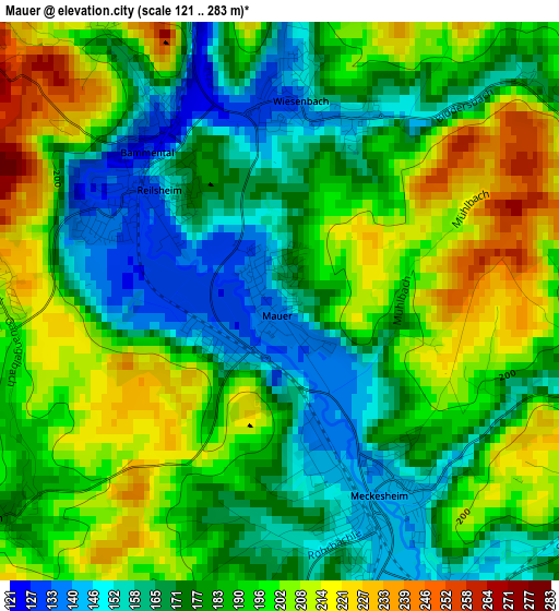
Below is the Elevation map of Mauer, which displays elevation range with different colors. Scale of the first map is from 121 to 283 m (397 to 928 ft) with average elevation of 185.8 meters (=610 ft) [note 1]
These maps also provides idea of topography and contour of this city, they are displayed at different zoom levels. More info about maps, scale and edge coordinates you can find below images.
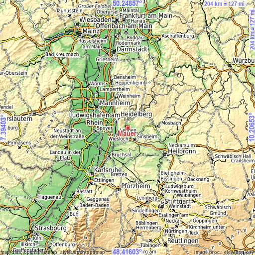
| \ | Map #1 | Topo.Map |
| Scale [m] | 121..283 m | × |
| Scale [ft] | 397..928 ft | × |
| Average | 185.8 m = 610 ft | × |
| Width | 6.37 km = 4 mi | 203.8 km = 126.6 mi |
| Height | 6.37 km = 4 mi | 203.7 km = 126.6 mi |
| ↑Max Latitude | 49.369455° | 50.24857° |
| Latitude at center | 49.34083° | 49.34083° |
| ↓Min Latitude | 49.312189° | 48.41603° |
| ← Min Longitude | 8.756335° | 7.39403° |
| Longitude center | 8.80028° | 8.80028° |
| →Max Longitude | 8.844225° | 10.20653° |
Nearby cities:
Cities around Mauer sort by population:
• Neckargemünd elevation 122 m
5.4 km,  356°
356°
• Dielheim 151 m
7.7 km,  215°
215°
• Bammental 128 m
2.3 km,  318°
318°
• Meckesheim 144 m
2.5 km,  146°
146°
• Wiesenbach 139 m
2.3 km,  6°
6°
• Eschelbronn 160 m
5.3 km,  116°
116°
• Gaiberg 291 m
4.6 km,  307°
307°
• Lobbach 220 m
7.5 km,  59°
59°
• Zuzenhausen 149 m
5.2 km,  161°
161°
• Neidenstein 166 m
6.7 km,  113°
113°
• Horrenberg 156 m
6.9 km,  191°
191°
• Spechbach 198 m
6 km,  84°
84°
Multilingual:
 En español:
Mauer elevación 141 m.
 En France:
Mauer élévation 141 m.


Sources and notes:
- [note 1] Map square and city borders are not equal. Map elevation data is calculated only from area inside that square.
- [src 1] Elevation data from geonames database provided with same terms of usage.
- [src 2] The elevation map of Mauer is generated using elevation data from NASA's 3 arcsec (90m) resolution SRTM data.
- [src 3] Base (background) map © OpenStreetMap contributors tiles are generated by Geofabrik and OpenTopoMap.
Copyright & License:
This Mauer Elevation Map is licensed under CC BY-SA. You may reuse any part from this page, if you give a proper credit by linking to this URL:
 More info on terms of use page.