Neuried elevation
Neuried (Bavaria, Upper Bavaria), Germany elevation is 558 meters and Neuried elevation in feet is 1831 ft above sea level [src 1]. Neuried is a seat of a fourth-order administrative division (feature code) with elevation that is 300 meters (984 ft) bigger than average city elevation in Germany.
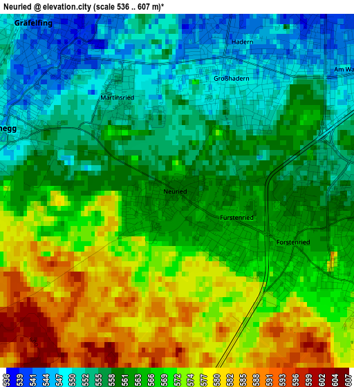
Below is the Elevation map of Neuried, which displays elevation range with different colors. Scale of the first map is from 536 to 607 m (1759 to 1991 ft) with average elevation of 564.1 meters (=1851 ft) [note 1]
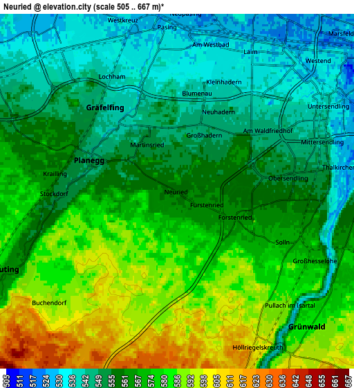
These maps also provides idea of topography and contour of this city, they are displayed at different zoom levels. More info about maps, scale and edge coordinates you can find below images.
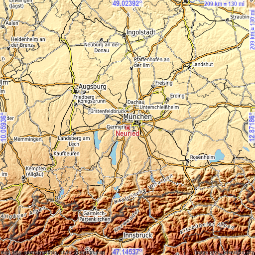
| \ | Map #1 | Map #2 | Topo.Map |
| Scale [m] | 536..607 m | 505..667 m | × |
| Scale [ft] | 1759..1991 ft | 1657..2188 ft | × |
| Average | 564.1 m = 1851 ft | 564.8 m = 1853 ft | × |
| Width | 6.53 km = 4.1 mi | 13.05 km = 8.1 mi | 208.9 km = 129.8 mi |
| Height | 6.53 km = 4.1 mi | 13.05 km = 8.1 mi | 208.9 km = 129.8 mi |
| ↑Max Latitude | 48.122564° | 48.15189° | 49.02392° |
| Latitude at center | 48.09322° | 48.09322° | 48.09322° |
| ↓Min Latitude | 48.06386° | 48.034483° | 47.14537° |
| ← Min Longitude | 11.421665° | 11.377719° | 10.05936° |
| Longitude center | 11.46561° | 11.46561° | 11.46561° |
| →Max Longitude | 11.509555° | 11.553501° | 12.87186° |
Nearby cities:
Cities around Neuried sort by population:
• Munich elevation 524 m
9.5 km,  58°
58°
• Germering 544 m
8 km,  304°
304°
• Pasing 527 m
5.4 km,  352°
352°
• Puchheim 527 m
10.7 km,  306°
306°
• Gauting 583 m
7.1 km,  247°
247°
• Gräfelfing 543 m
3.9 km,  316°
316°
• Grünwald 595 m
7.4 km,  144°
144°
• Planegg 547 m
3.4 km, 296°
• Pullach im Isartal 582 m
5.5 km,  130°
130°
• Krailling 562 m
4.9 km,  278°
278°
• Straßlach-Dingharting 634 m
10.5 km,  159°
159°
• Baierbrunn 619 m
8.3 km,  168°
168°
Multilingual:
 En español:
Neuried elevación 558 m.
 En France:
Neuried élévation 558 m.


Sources and notes:
- [note 1] Map square and city borders are not equal. Map elevation data is calculated only from area inside that square.
- [src 1] Elevation data from geonames database provided with same terms of usage.
- [src 2] The elevation map of Neuried is generated using elevation data from NASA's 3 arcsec (90m) resolution SRTM data.
- [src 3] Base (background) map © OpenStreetMap contributors tiles are generated by Geofabrik and OpenTopoMap.
Copyright & License:
This Neuried Elevation Map is licensed under CC BY-SA. You may reuse any part from this page, if you give a proper credit by linking to this URL:
 More info on terms of use page.