Obing elevation
Obing (Bavaria, Upper Bavaria), Germany elevation is 567 meters and Obing elevation in feet is 1860 ft above sea level [src 1]. Obing is a seat of a fourth-order administrative division (feature code) with elevation that is 309 meters (1014 ft) bigger than average city elevation in Germany.
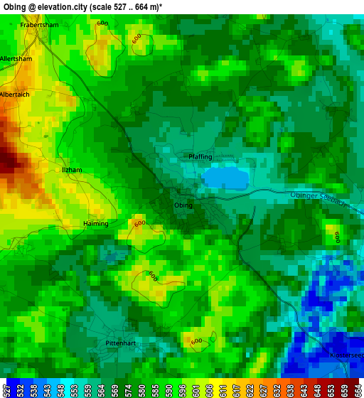
Below is the Elevation map of Obing, which displays elevation range with different colors. Scale of the first map is from 527 to 664 m (1729 to 2178 ft) with average elevation of 578.6 meters (=1898 ft) [note 1]
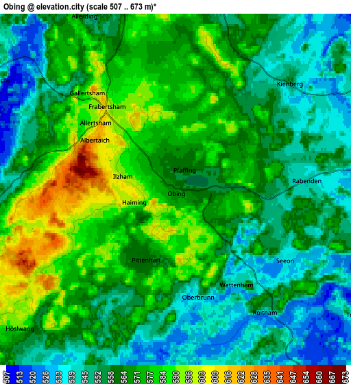
These maps also provides idea of topography and contour of this city, they are displayed at different zoom levels. More info about maps, scale and edge coordinates you can find below images.
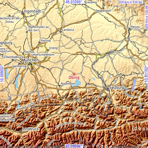
| \ | Map #1 | Map #2 | Topo.Map |
| Scale [m] | 527..664 m | 507..673 m | × |
| Scale [ft] | 1729..2178 ft | 1663..2208 ft | × |
| Average | 578.6 m = 1898 ft | 564.1 m = 1851 ft | × |
| Width | 6.54 km = 4.1 mi | 13.08 km = 8.1 mi | 209.3 km = 130.1 mi |
| Height | 6.54 km = 4.1 mi | 13.08 km = 8.1 mi | 209.2 km = 130 mi |
| ↑Max Latitude | 48.029886° | 48.059266° | 48.93288° |
| Latitude at center | 48.00049° | 48.00049° | 48.00049° |
| ↓Min Latitude | 47.971077° | 47.941647° | 47.05094° |
| ← Min Longitude | 12.361335° | 12.317389° | 10.99903° |
| Longitude center | 12.40528° | 12.40528° | 12.40528° |
| →Max Longitude | 12.449225° | 12.493171° | 13.81153° |
Nearby cities:
Cities around Obing sort by population:
• Trostberg an der Alz elevation 482 m
11.8 km,  74°
74°
• Bad Endorf 519 m
12.9 km,  218°
218°
• Seeon-Seebruck 574 m
5.9 km,  129°
129°
• Amerang 538 m
7.3 km,  262°
262°
• Schnaitsee 576 m
7.9 km,  338°
338°
• Eggstätt 538 m
8.4 km,  193°
193°
• Halfing 502 m
11.1 km,  240°
240°
• Pittenhart 560 m
2.8 km,  203°
203°
• Gstadt am Chiemsee 524 m
12.9 km,  175°
175°
• Kienberg 550 m
5.8 km,  48°
48°
• Höslwang 594 m
7.7 km,  227°
227°
• Schonstett 485 m
11.7 km, 260°
Multilingual:
 En español:
Obing elevación 567 m.
 En France:
Obing élévation 567 m.


Sources and notes:
- [note 1] Map square and city borders are not equal. Map elevation data is calculated only from area inside that square.
- [src 1] Elevation data from geonames database provided with same terms of usage.
- [src 2] The elevation map of Obing is generated using elevation data from NASA's 3 arcsec (90m) resolution SRTM data.
- [src 3] Base (background) map © OpenStreetMap contributors tiles are generated by Geofabrik and OpenTopoMap.
Copyright & License:
This Obing Elevation Map is licensed under CC BY-SA. You may reuse any part from this page, if you give a proper credit by linking to this URL:
 More info on terms of use page.