Gstadt am Chiemsee elevation
Gstadt am Chiemsee (Bavaria, Upper Bavaria), Germany elevation is 524 meters and Gstadt am Chiemsee elevation in feet is 1719 ft above sea level [src 1]. Gstadt am Chiemsee is a populated place (feature code) with elevation that is 266 meters (873 ft) bigger than average city elevation in Germany.
Below is the Elevation map of Gstadt am Chiemsee, which displays elevation range with different colors. Scale of the first map is from 511 to 567 m (1677 to 1860 ft) with average elevation of 524.8 meters (=1722 ft) [note 1]
These maps also provides idea of topography and contour of this city, they are displayed at different zoom levels. More info about maps, scale and edge coordinates you can find below images.
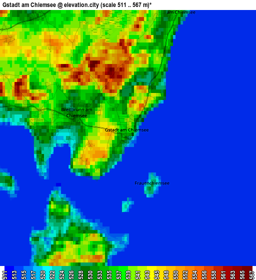
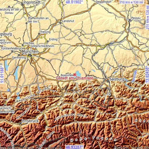
| \ | Map #1 | Topo.Map |
| Scale [m] | 511..567 m | × |
| Scale [ft] | 1677..1860 ft | × |
| Average | 524.8 m = 1722 ft | × |
| Width | 6.55 km = 4.1 mi | 209.7 km = 130.3 mi |
| Height | 6.55 km = 4.1 mi | 209.7 km = 130.3 mi |
| ↑Max Latitude | 47.913993° | 48.81902° |
| Latitude at center | 47.88453° | 47.88453° |
| ↓Min Latitude | 47.855051° | 46.93287° |
| ← Min Longitude | 12.374185° | 11.01188° |
| Longitude center | 12.41813° | 12.41813° |
| →Max Longitude | 12.462075° | 13.82438° |
Nearby cities:
Cities around Gstadt am Chiemsee sort by population:
• Prien am Chiemsee elevation 533 m
6.2 km,  239°
239°
• Bad Endorf 519 m
9.4 km,  286°
286°
• Bernau am Chiemsee 540 m
8.7 km,  201°
201°
• Grassau 537 m
11.8 km,  167°
167°
• Übersee 525 m
9 km,  147°
147°
• Seeon-Seebruck 574 m
9.8 km,  21°
21°
• Chieming 532 m
9.1 km,  84°
84°
• Grabenstätt 522 m
10.3 km,  115°
115°
• Rimsting 562 m
6.1 km,  266°
266°
• Eggstätt 538 m
5.5 km,  328°
328°
• Pittenhart 560 m
10.5 km,  348°
348°
• Höslwang 594 m
10.2 km,  319°
319°
Multilingual:
 En español:
Gstadt am Chiemsee elevación 524 m.
 En France:
Gstadt am Chiemsee élévation 524 m.
 Auf Deutsch:
Gstadt am Chiemsee höhe über dem Meeresspiegel ist 524 m.
 На русском:
Gstadt am Chiemsee высота над уровнем моря 524 м
Sources and notes:
- [note 1] Map square and city borders are not equal. Map elevation data is calculated only from area inside that square.
- [src 1] Elevation data from geonames database provided with same terms of usage.
- [src 2] The elevation map of Gstadt am Chiemsee is generated using elevation data from NASA's 3 arcsec (90m) resolution SRTM data.
- [src 3] Base (background) map © OpenStreetMap contributors tiles are generated by Geofabrik and OpenTopoMap.
Copyright & License:
This Gstadt am Chiemsee Elevation Map is licensed under CC BY-SA. You may reuse any part from this page, if you give a proper credit by linking to this URL:
 More info on terms of use page.