Reuth elevation
Reuth (Bavaria, Upper Franconia), Germany elevation is 510 meters and Reuth elevation in feet is 1673 ft above sea level [src 1]. Reuth is a populated place (feature code) with elevation that is 252 meters (827 ft) bigger than average city elevation in Germany.
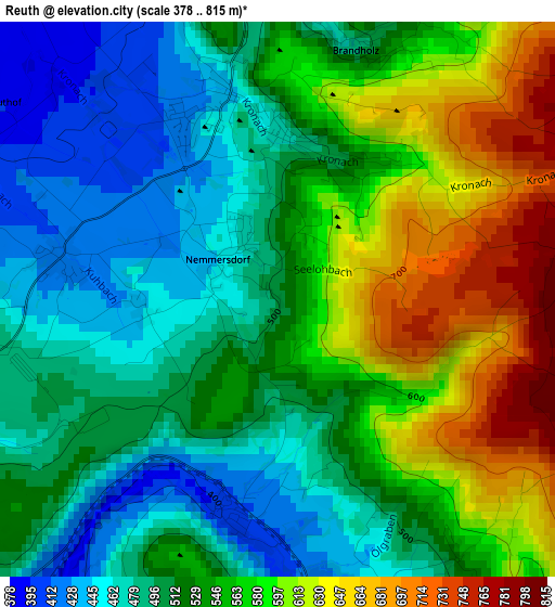
Below is the Elevation map of Reuth, which displays elevation range with different colors. Scale of the first map is from 378 to 815 m (1240 to 2674 ft) with average elevation of 537.5 meters (=1763 ft) [note 1]
These maps also provides idea of topography and contour of this city, they are displayed at different zoom levels. More info about maps, scale and edge coordinates you can find below images.
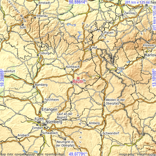
| \ | Map #1 | Topo.Map |
| Scale [m] | 378..815 m | × |
| Scale [ft] | 1240..2674 ft | × |
| Average | 537.5 m = 1763 ft | × |
| Width | 6.28 km = 3.9 mi | 201.1 km = 125 mi |
| Height | 6.28 km = 3.9 mi | 201 km = 124.9 mi |
| ↑Max Latitude | 50.018765° | 50.88614° |
| Latitude at center | 49.99052° | 49.99052° |
| ↓Min Latitude | 49.962259° | 49.07791° |
| ← Min Longitude | 11.650855° | 10.28855° |
| Longitude center | 11.6948° | 11.6948° |
| →Max Longitude | 11.738745° | 13.10105° |
Nearby cities:
Cities around Reuth sort by population:
• Bayreuth elevation 338 m
9.6 km,  240°
240°
• Neunkirchen am Main 386 m
8.2 km,  204°
204°
• Bindlach 360 m
5.9 km,  260°
260°
• Bad Berneck im Fichtelgebirge 412 m
6.3 km,  345°
345°
• Goldkronach 443 m
2.3 km, 347°
• Himmelkron 356 m
10.8 km,  321°
321°
• Warmensteinach 553 m
6 km,  86°
86°
• Bischofsgrün 681 m
10.1 km,  48°
48°
• Kirchenpingarten 578 m
9 km,  135°
135°
• Seybothenreuth 425 m
10.8 km,  176°
176°
• Gesees 428 m
5.1 km,  336°
336°
• Harsdorf 398 m
10.3 km,  297°
297°
Multilingual:
 En español:
Reuth elevación 510 m.
 En France:
Reuth élévation 510 m.


Sources and notes:
- [note 1] Map square and city borders are not equal. Map elevation data is calculated only from area inside that square.
- [src 1] Elevation data from geonames database provided with same terms of usage.
- [src 2] The elevation map of Reuth is generated using elevation data from NASA's 3 arcsec (90m) resolution SRTM data.
- [src 3] Base (background) map © OpenStreetMap contributors tiles are generated by Geofabrik and OpenTopoMap.
Copyright & License:
This Reuth Elevation Map is licensed under CC BY-SA. You may reuse any part from this page, if you give a proper credit by linking to this URL:
 More info on terms of use page.