Bischofsgrün elevation
Bischofsgrün (Bavaria, Upper Franconia), Germany elevation is 681 meters and Bischofsgrün elevation in feet is 2234 ft above sea level [src 1]. Bischofsgrün is a seat of a fourth-order administrative division (feature code) with elevation that is 423 meters (1388 ft) bigger than average city elevation in Germany.
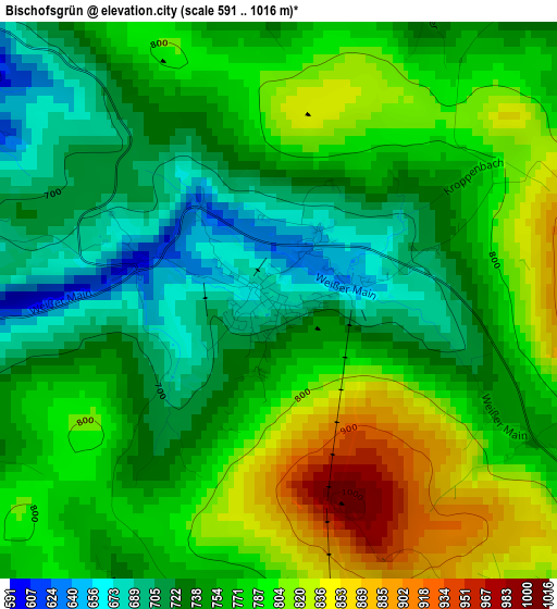
Below is the Elevation map of Bischofsgrün, which displays elevation range with different colors. Scale of the first map is from 591 to 1016 m (1939 to 3333 ft) with average elevation of 764.7 meters (=2509 ft) [note 1]
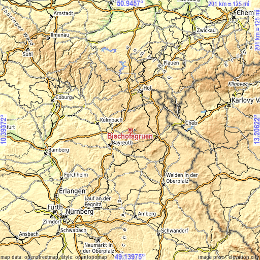
These maps also provides idea of topography and contour of this city, they are displayed at different zoom levels. More info about maps, scale and edge coordinates you can find below images.
| \ | Map #1 | Topo.Map |
| Scale [m] | 591..1016 m | × |
| Scale [ft] | 1939..3333 ft | × |
| Average | 764.7 m = 2509 ft | × |
| Width | 6.27 km = 3.9 mi | 200.8 km = 124.8 mi |
| Height | 6.27 km = 3.9 mi | 200.8 km = 124.8 mi |
| ↑Max Latitude | 50.079429° | 50.9457° |
| Latitude at center | 50.05122° | 50.05122° |
| ↓Min Latitude | 50.022994° | 49.13975° |
| ← Min Longitude | 11.756025° | 10.39372° |
| Longitude center | 11.79997° | 11.79997° |
| →Max Longitude | 11.843915° | 13.20622° |
Nearby cities:
Cities around Bischofsgrün sort by population:
• Gefrees elevation 498 m
6.6 km,  317°
317°
• Bad Berneck im Fichtelgebirge 412 m
9.1 km,  266°
266°
• Oberhaid 629 m
8.3 km,  2°
2°
• Goldkronach 443 m
9.2 km,  240°
240°
• Weißenstadt 622 m
8.5 km,  48°
48°
• Grub 614 m
10.9 km,  58°
58°
• Warmensteinach 553 m
6.6 km,  193°
193°
• Zell im Fichtelgebirge 621 m
9.5 km,  9°
9°
• Fichtelberg 695 m
6.6 km,  144°
144°
• Mehlmeisel 628 m
9.6 km,  152°
152°
• Reuth 510 m
10.1 km,  228°
228°
• Gesees 428 m
9.8 km,  257°
257°
Multilingual:
 En español:
Bischofsgrün elevación 681 m.
 En France:
Bischofsgrün élévation 681 m.
 Auf Deutsch:
Bischofsgrün höhe über dem Meeresspiegel ist 681 m.

Sources and notes:
- [note 1] Map square and city borders are not equal. Map elevation data is calculated only from area inside that square.
- [src 1] Elevation data from geonames database provided with same terms of usage.
- [src 2] The elevation map of Bischofsgrün is generated using elevation data from NASA's 3 arcsec (90m) resolution SRTM data.
- [src 3] Base (background) map © OpenStreetMap contributors tiles are generated by Geofabrik and OpenTopoMap.
Copyright & License:
This Bischofsgrün Elevation Map is licensed under CC BY-SA. You may reuse any part from this page, if you give a proper credit by linking to this URL:
 More info on terms of use page.