Rotthalmünster elevation
Rotthalmünster (Bavaria, Lower Bavaria), Germany elevation is 370 meters and Rotthalmünster elevation in feet is 1214 ft above sea level [src 1]. Rotthalmünster is a populated place (feature code) with elevation that is 112 meters (367 ft) bigger than average city elevation in Germany.
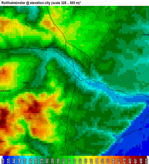
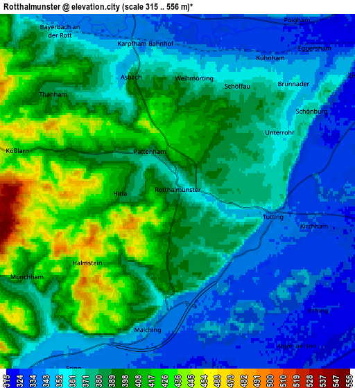
Below is the Elevation map of Rotthalmünster, which displays elevation range with different colors. Scale of the first map is from 328 to 505 m (1076 to 1657 ft) with average elevation of 395.5 meters (=1298 ft) [note 1]
These maps also provides idea of topography and contour of this city, they are displayed at different zoom levels. More info about maps, scale and edge coordinates you can find below images.
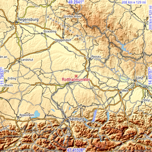
| \ | Map #1 | Map #2 | Topo.Map |
| Scale [m] | 328..505 m | 315..556 m | × |
| Scale [ft] | 1076..1657 ft | 1033..1824 ft | × |
| Average | 395.5 m = 1298 ft | 376.1 m = 1234 ft | × |
| Width | 6.49 km = 4 mi | 12.99 km = 8.1 mi | 207.8 km = 129.1 mi |
| Height | 6.49 km = 4 mi | 12.99 km = 8.1 mi | 207.8 km = 129.1 mi |
| ↑Max Latitude | 48.387442° | 48.416617° | 49.2841° |
| Latitude at center | 48.35825° | 48.35825° | 48.35825° |
| ↓Min Latitude | 48.329041° | 48.299816° | 47.41526° |
| ← Min Longitude | 13.157675° | 13.113729° | 11.79537° |
| Longitude center | 13.20162° | 13.20162° | 13.20162° |
| →Max Longitude | 13.245565° | 13.289511° | 14.60787° |
Nearby cities:
Cities around Rotthalmünster sort by population:
• Pocking elevation 321 m
9.5 km,  59°
59°
• Bad Griesbach 454 m
10.4 km,  356°
356°
• Bad Füssing 325 m
8.2 km,  95°
95°
• Bad Birnbach 360 m
12.6 km,  319°
319°
• Triftern 392 m
15 km,  285°
285°
• Kirchham 333 m
5 km,  105°
105°
• Chostlarn 431 m
6.2 km,  283°
283°
• Ering 343 m
7.6 km,  210°
210°
• Tettenweis 334 m
10.7 km,  28°
28°
• Bayerbach 357 m
7.2 km, 323°
• Stubenberg 473 m
9.9 km,  242°
242°
• Malching 343 m
5.2 km,  191°
191°
Multilingual:
 En español:
Rotthalmünster elevación 370 m.
 En France:
Rotthalmünster élévation 370 m.
 Auf Deutsch:
Rotthalmünster höhe über dem Meeresspiegel ist 370 m.

Sources and notes:
- [note 1] Map square and city borders are not equal. Map elevation data is calculated only from area inside that square.
- [src 1] Elevation data from geonames database provided with same terms of usage.
- [src 2] The elevation map of Rotthalmünster is generated using elevation data from NASA's 3 arcsec (90m) resolution SRTM data.
- [src 3] Base (background) map © OpenStreetMap contributors tiles are generated by Geofabrik and OpenTopoMap.
Copyright & License:
This Rotthalmünster Elevation Map is licensed under CC BY-SA. You may reuse any part from this page, if you give a proper credit by linking to this URL:
 More info on terms of use page.