Triftern elevation
Triftern (Bavaria, Lower Bavaria), Germany elevation is 392 meters and Triftern elevation in feet is 1286 ft above sea level [src 1]. Triftern is a populated place (feature code) with elevation that is 134 meters (440 ft) bigger than average city elevation in Germany.
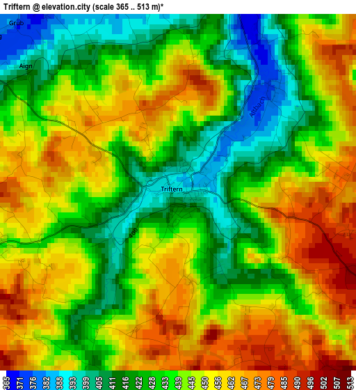
Below is the Elevation map of Triftern, which displays elevation range with different colors. Scale of the first map is from 365 to 513 m (1198 to 1683 ft) with average elevation of 440.9 meters (=1447 ft) [note 1]
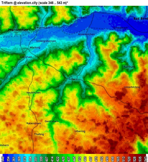
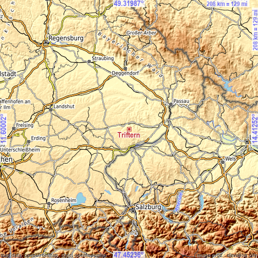
These maps also provides idea of topography and contour of this city, they are displayed at different zoom levels. More info about maps, scale and edge coordinates you can find below images.
| \ | Map #1 | Map #2 | Topo.Map |
| Scale [m] | 365..513 m | 346..543 m | × |
| Scale [ft] | 1198..1683 ft | 1135..1781 ft | × |
| Average | 440.9 m = 1447 ft | 444.8 m = 1459 ft | × |
| Width | 6.49 km = 4 mi | 12.98 km = 8.1 mi | 207.6 km = 129 mi |
| Height | 6.49 km = 4 mi | 12.98 km = 8.1 mi | 207.6 km = 129 mi |
| ↑Max Latitude | 48.423851° | 48.453006° | 49.31987° |
| Latitude at center | 48.39468° | 48.39468° | 48.39468° |
| ↓Min Latitude | 48.365492° | 48.336288° | 47.45236° |
| ← Min Longitude | 12.962325° | 12.918379° | 11.60002° |
| Longitude center | 13.00627° | 13.00627° | 13.00627° |
| →Max Longitude | 13.050215° | 13.094161° | 14.41252° |
Nearby cities:
Cities around Triftern sort by population:
• Pfarrkirchen elevation 384 m
6.5 km,  309°
309°
• Simbach am Inn 355 m
14.4 km,  175°
175°
• Bad Birnbach 360 m
8.4 km,  48°
48°
• Rotthalmünster 370 m
15 km,  105°
105°
• Tann 447 m
12.2 km,  223°
223°
• Hebertsfelden 428 m
13.6 km,  275°
275°
• Dietersburg 416 m
12.4 km,  331°
331°
• Postmünster 405 m
8.2 km,  287°
287°
• Chostlarn 431 m
8.8 km, 107°
• Ering 343 m
15 km,  134°
134°
• Bayerbach 357 m
10.3 km,  80°
80°
• Stubenberg 473 m
10.4 km,  146°
146°
Multilingual:
 En español:
Triftern elevación 392 m.
 En France:
Triftern élévation 392 m.
 Auf Deutsch:
Triftern höhe über dem Meeresspiegel ist 392 m.

Sources and notes:
- [note 1] Map square and city borders are not equal. Map elevation data is calculated only from area inside that square.
- [src 1] Elevation data from geonames database provided with same terms of usage.
- [src 2] The elevation map of Triftern is generated using elevation data from NASA's 3 arcsec (90m) resolution SRTM data.
- [src 3] Base (background) map © OpenStreetMap contributors tiles are generated by Geofabrik and OpenTopoMap.
Copyright & License:
This Triftern Elevation Map is licensed under CC BY-SA. You may reuse any part from this page, if you give a proper credit by linking to this URL:
 More info on terms of use page.