Postmünster elevation
Postmünster (Bavaria, Lower Bavaria), Germany elevation is 405 meters and Postmünster elevation in feet is 1329 ft above sea level [src 1]. Postmünster is a seat of a fourth-order administrative division (feature code) with elevation that is 147 meters (482 ft) bigger than average city elevation in Germany.
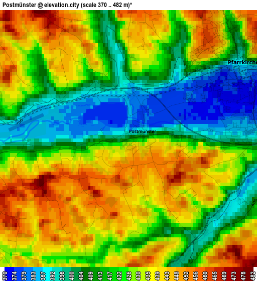
Below is the Elevation map of Postmünster, which displays elevation range with different colors. Scale of the first map is from 370 to 482 m (1214 to 1581 ft) with average elevation of 424.2 meters (=1392 ft) [note 1]
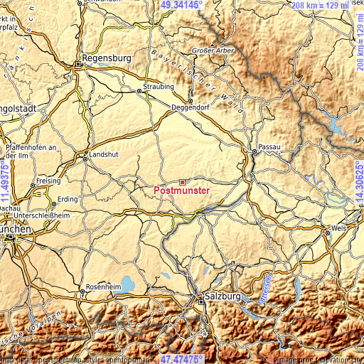
These maps also provides idea of topography and contour of this city, they are displayed at different zoom levels. More info about maps, scale and edge coordinates you can find below images.
| \ | Map #1 | Topo.Map |
| Scale [m] | 370..482 m | × |
| Scale [ft] | 1214..1581 ft | × |
| Average | 424.2 m = 1392 ft | × |
| Width | 6.49 km = 4 mi | 207.6 km = 129 mi |
| Height | 6.49 km = 4 mi | 207.5 km = 128.9 mi |
| ↑Max Latitude | 48.445829° | 49.34145° |
| Latitude at center | 48.41667° | 48.41667° |
| ↓Min Latitude | 48.387495° | 47.47475° |
| ← Min Longitude | 12.856055° | 11.49375° |
| Longitude center | 12.9° | 12.9° |
| →Max Longitude | 12.943945° | 14.30625° |
Nearby cities:
Cities around Postmünster sort by population:
• Eggenfelden elevation 405 m
10.6 km,  263°
263°
• Pfarrkirchen 384 m
3.3 km,  58°
58°
• Bad Birnbach 360 m
14.4 km,  77°
77°
• Triftern 392 m
8.2 km,  107°
107°
• Tann 447 m
11.4 km,  182°
182°
• Falkenberg 478 m
13.5 km,  291°
291°
• Hebertsfelden 428 m
5.8 km, 258°
• Wurmannsquick 497 m
11 km,  230°
230°
• Dietersburg 416 m
8.6 km,  12°
12°
• Johanniskirchen 365 m
13.5 km,  15°
15°
• Zeilarn 445 m
13.6 km,  198°
198°
• Schönau 440 m
8.3 km,  333°
333°
Multilingual:
 En español:
Postmünster elevación 405 m.
 En France:
Postmünster élévation 405 m.
 Auf Deutsch:
Postmünster höhe über dem Meeresspiegel ist 405 m.

Sources and notes:
- [note 1] Map square and city borders are not equal. Map elevation data is calculated only from area inside that square.
- [src 1] Elevation data from geonames database provided with same terms of usage.
- [src 2] The elevation map of Postmünster is generated using elevation data from NASA's 3 arcsec (90m) resolution SRTM data.
- [src 3] Base (background) map © OpenStreetMap contributors tiles are generated by Geofabrik and OpenTopoMap.
Copyright & License:
This Postmünster Elevation Map is licensed under CC BY-SA. You may reuse any part from this page, if you give a proper credit by linking to this URL:
 More info on terms of use page.