Schlotheim elevation
Schlotheim (Thuringia), Germany elevation is 242 meters and Schlotheim elevation in feet is 794 ft above sea level [src 1]. Schlotheim is a populated place (feature code) with elevation that is 16 meters (52 ft) smaller than average city elevation in Germany.
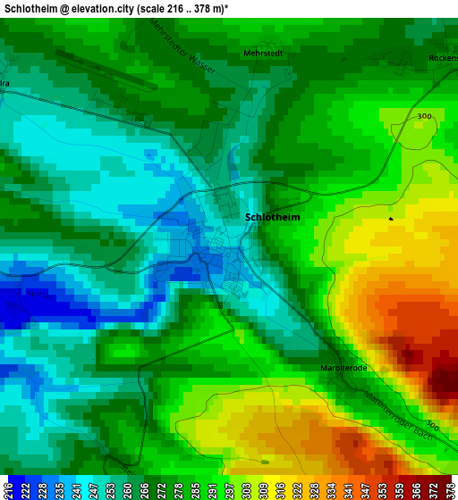
Below is the Elevation map of Schlotheim, which displays elevation range with different colors. Scale of the first map is from 216 to 378 m (709 to 1240 ft) with average elevation of 277.2 meters (=909 ft) [note 1]
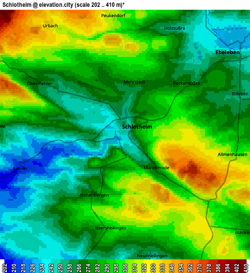
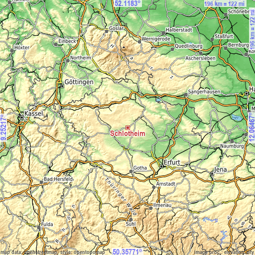
These maps also provides idea of topography and contour of this city, they are displayed at different zoom levels. More info about maps, scale and edge coordinates you can find below images.
| \ | Map #1 | Map #2 | Topo.Map |
| Scale [m] | 216..378 m | 202..410 m | × |
| Scale [ft] | 709..1240 ft | 663..1345 ft | × |
| Average | 277.2 m = 909 ft | 283.2 m = 929 ft | × |
| Width | 6.12 km = 3.8 mi | 12.23 km = 7.6 mi | 195.8 km = 121.7 mi |
| Height | 6.12 km = 3.8 mi | 12.23 km = 7.6 mi | 195.7 km = 121.6 mi |
| ↑Max Latitude | 51.27393° | 51.301414° | 52.1183° |
| Latitude at center | 51.24643° | 51.24643° | 51.24643° |
| ↓Min Latitude | 51.218913° | 51.19138° | 50.35771° |
| ← Min Longitude | 10.614475° | 10.570529° | 9.25217° |
| Longitude center | 10.65842° | 10.65842° | 10.65842° |
| →Max Longitude | 10.702365° | 10.746311° | 12.06467° |
Nearby cities:
Cities around Schlotheim sort by population:
• Schernberg elevation 334 m
11.9 km,  40°
40°
• Ebeleben 249 m
6.4 km,  50°
50°
• Sollstedt 459 m
13.8 km,  300°
300°
• Menteroda 423 m
9.5 km,  315°
315°
• Großenehrich 248 m
12.3 km,  88°
88°
• Seebach 195 m
13.5 km,  227°
227°
• Großengottern 184 m
12.8 km,  211°
211°
• Körner 220 m
5.1 km,  250°
250°
• Altengottern 179 m
10.6 km, 210°
• Freienbessingen 295 m
7.7 km,  100°
100°
• Obermehler 269 m
5 km, 301°
• Urbach 336 m
6.5 km,  325°
325°
Multilingual:
 En español:
Schlotheim elevación 242 m.
 En France:
Schlotheim élévation 242 m.
 Auf Deutsch:
Schlotheim höhe über dem Meeresspiegel ist 242 m.

Sources and notes:
- [note 1] Map square and city borders are not equal. Map elevation data is calculated only from area inside that square.
- [src 1] Elevation data from geonames database provided with same terms of usage.
- [src 2] The elevation map of Schlotheim is generated using elevation data from NASA's 3 arcsec (90m) resolution SRTM data.
- [src 3] Base (background) map © OpenStreetMap contributors tiles are generated by Geofabrik and OpenTopoMap.
Copyright & License:
This Schlotheim Elevation Map is licensed under CC BY-SA. You may reuse any part from this page, if you give a proper credit by linking to this URL:
 More info on terms of use page.