Großengottern elevation
Großengottern (Thuringia), Germany elevation is 184 meters and Großengottern elevation in feet is 604 ft above sea level [src 1]. Großengottern is a seat of a fourth-order administrative division (feature code) with elevation that is 74 meters (243 ft) smaller than average city elevation in Germany.
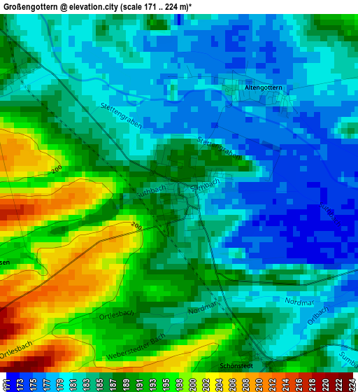
Below is the Elevation map of Großengottern, which displays elevation range with different colors. Scale of the first map is from 171 to 224 m (561 to 735 ft) with average elevation of 186.9 meters (=613 ft) [note 1]
These maps also provides idea of topography and contour of this city, they are displayed at different zoom levels. More info about maps, scale and edge coordinates you can find below images.
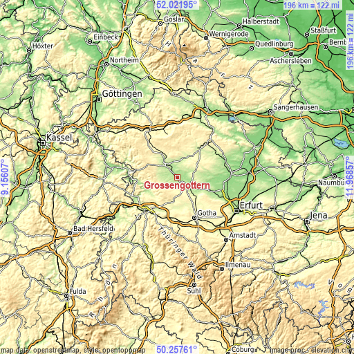
| \ | Map #1 | Topo.Map |
| Scale [m] | 171..224 m | × |
| Scale [ft] | 561..735 ft | × |
| Average | 186.9 m = 613 ft | × |
| Width | 6.13 km = 3.8 mi | 196.2 km = 121.9 mi |
| Height | 6.13 km = 3.8 mi | 196.2 km = 121.9 mi |
| ↑Max Latitude | 51.175769° | 52.02195° |
| Latitude at center | 51.14821° | 51.14821° |
| ↓Min Latitude | 51.120635° | 50.25761° |
| ← Min Longitude | 10.518375° | 9.15607° |
| Longitude center | 10.56232° | 10.56232° |
| →Max Longitude | 10.606265° | 11.96857° |
Nearby cities:
Cities around Großengottern sort by population:
• Mühlhausen elevation 221 m
10.2 km,  311°
311°
• Bad Langensalza 192 m
7.4 km,  127°
127°
• Schlotheim 242 m
12.8 km,  31°
31°
• Seebach 195 m
3.8 km,  299°
299°
• Oberdorla 228 m
10 km,  281°
281°
• Körner 220 m
9.4 km,  11°
11°
• Schönstedt 185 m
3.3 km,  161°
161°
• Niederdorla 204 m
8.1 km, 279°
• Altengottern 179 m
2.2 km,  36°
36°
• Langula 238 m
10.2 km,  271°
271°
• Obermehler 269 m
13.8 km, 10°
• Urbach 336 m
16.6 km, 10°
Multilingual:
 En español:
Großengottern elevación 184 m.
 En France:
Großengottern élévation 184 m.
 Auf Deutsch:
Großengottern höhe über dem Meeresspiegel ist 184 m.

Sources and notes:
- [note 1] Map square and city borders are not equal. Map elevation data is calculated only from area inside that square.
- [src 1] Elevation data from geonames database provided with same terms of usage.
- [src 2] The elevation map of Großengottern is generated using elevation data from NASA's 3 arcsec (90m) resolution SRTM data.
- [src 3] Base (background) map © OpenStreetMap contributors tiles are generated by Geofabrik and OpenTopoMap.
Copyright & License:
This Großengottern Elevation Map is licensed under CC BY-SA. You may reuse any part from this page, if you give a proper credit by linking to this URL:
 More info on terms of use page.