Sohren elevation
Sohren (Rheinland-Pfalz), Germany elevation is 429 meters and Sohren elevation in feet is 1407 ft above sea level [src 1]. Sohren is a seat of a fourth-order administrative division (feature code) with elevation that is 171 meters (561 ft) bigger than average city elevation in Germany.
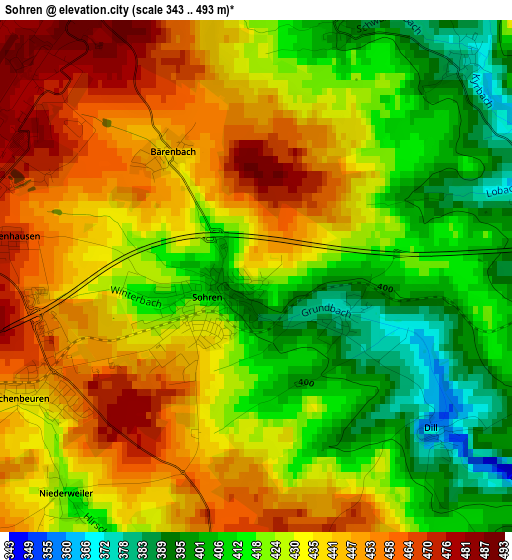
Below is the Elevation map of Sohren, which displays elevation range with different colors. Scale of the first map is from 343 to 493 m (1125 to 1617 ft) with average elevation of 429.6 meters (=1409 ft) [note 1]
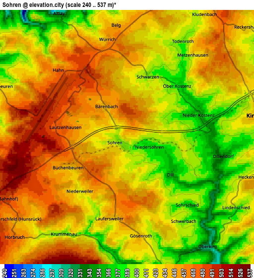
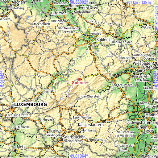
These maps also provides idea of topography and contour of this city, they are displayed at different zoom levels. More info about maps, scale and edge coordinates you can find below images.
| \ | Map #1 | Map #2 | Topo.Map |
| Scale [m] | 343..493 m | 240..537 m | × |
| Scale [ft] | 1125..1617 ft | 787..1762 ft | × |
| Average | 429.6 m = 1409 ft | 428.2 m = 1405 ft | × |
| Width | 6.29 km = 3.9 mi | 12.58 km = 7.8 mi | 201.3 km = 125.1 mi |
| Height | 6.29 km = 3.9 mi | 12.58 km = 7.8 mi | 201.3 km = 125.1 mi |
| ↑Max Latitude | 49.961608° | 49.98987° | 50.83002° |
| Latitude at center | 49.93333° | 49.93333° | 49.93333° |
| ↓Min Latitude | 49.905035° | 49.876723° | 49.01964° |
| ← Min Longitude | 7.272725° | 7.228779° | 5.91042° |
| Longitude center | 7.31667° | 7.31667° | 7.31667° |
| →Max Longitude | 7.360615° | 7.404561° | 8.72292° |
Nearby cities:
Cities around Sohren sort by population:
• Traben-Trarbach elevation 111 m
14.5 km,  277°
277°
• Zell 129 m
14.3 km,  317°
317°
• Kirchberg 435 m
6.6 km,  79°
79°
• Rhaunen 344 m
7.9 km,  166°
166°
• Blankenrath 399 m
11.8 km,  354°
354°
• Enkirch 113 m
14.5 km,  293°
293°
• Büchenbeuren 446 m
3 km,  242°
242°
• Gemünden 283 m
12.3 km,  110°
110°
• Mastershausen 413 m
15 km,  9°
9°
• Longkamp 409 m
15 km,  251°
251°
• Briedel 256 m
15.1 km,  307°
307°
• Bundenbach 393 m
11 km,  156°
156°
Multilingual:
 En español:
Sohren elevación 429 m.
 En France:
Sohren élévation 429 m.


Sources and notes:
- [note 1] Map square and city borders are not equal. Map elevation data is calculated only from area inside that square.
- [src 1] Elevation data from geonames database provided with same terms of usage.
- [src 2] The elevation map of Sohren is generated using elevation data from NASA's 3 arcsec (90m) resolution SRTM data.
- [src 3] Base (background) map © OpenStreetMap contributors tiles are generated by Geofabrik and OpenTopoMap.
Copyright & License:
This Sohren Elevation Map is licensed under CC BY-SA. You may reuse any part from this page, if you give a proper credit by linking to this URL:
 More info on terms of use page.