Stadtilm elevation
Stadtilm (Thuringia), Germany elevation is 358 meters and Stadtilm elevation in feet is 1175 ft above sea level [src 1]. Stadtilm is a populated place (feature code) with elevation that is 100 meters (328 ft) bigger than average city elevation in Germany.
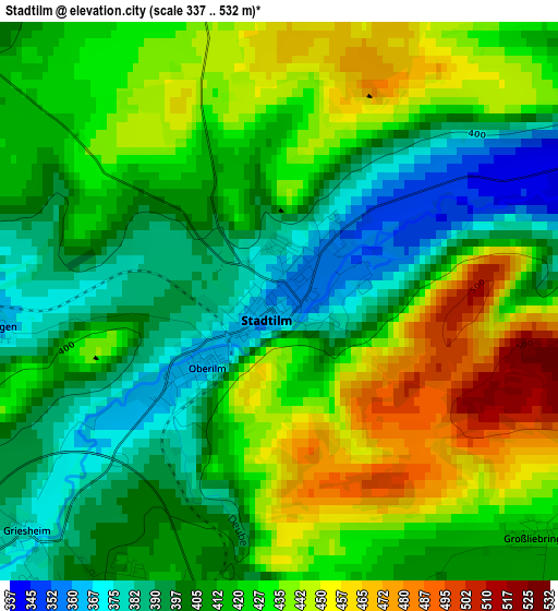
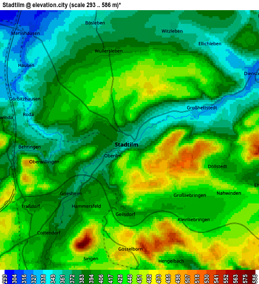
Below is the Elevation map of Stadtilm, which displays elevation range with different colors. Scale of the first map is from 337 to 532 m (1106 to 1745 ft) with average elevation of 418.3 meters (=1372 ft) [note 1]
These maps also provides idea of topography and contour of this city, they are displayed at different zoom levels. More info about maps, scale and edge coordinates you can find below images.
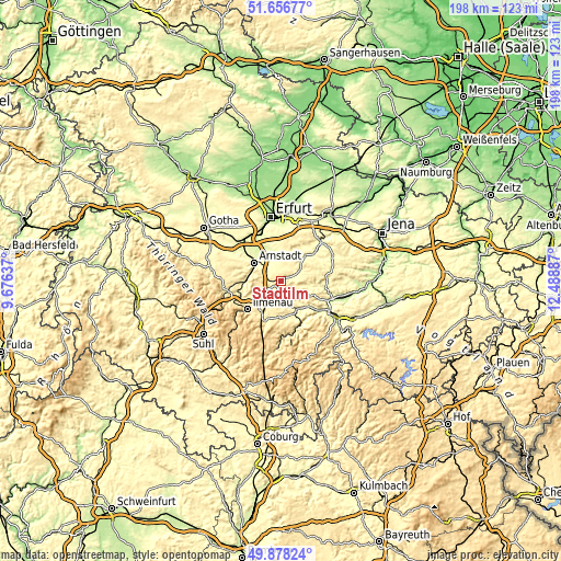
| \ | Map #1 | Map #2 | Topo.Map |
| Scale [m] | 337..532 m | 293..586 m | × |
| Scale [ft] | 1106..1745 ft | 961..1923 ft | × |
| Average | 418.3 m = 1372 ft | 407.4 m = 1337 ft | × |
| Width | 6.18 km = 3.8 mi | 12.36 km = 7.7 mi | 197.8 km = 122.9 mi |
| Height | 6.18 km = 3.8 mi | 12.36 km = 7.7 mi | 197.7 km = 122.8 mi |
| ↑Max Latitude | 50.803741° | 50.831505° | 51.65677° |
| Latitude at center | 50.77596° | 50.77596° | 50.77596° |
| ↓Min Latitude | 50.748163° | 50.720349° | 49.87824° |
| ← Min Longitude | 11.038675° | 10.994729° | 9.67637° |
| Longitude center | 11.08262° | 11.08262° | 11.08262° |
| →Max Longitude | 11.126565° | 11.170511° | 12.48887° |
Nearby cities:
Cities around Stadtilm sort by population:
• Arnstadt elevation 274 m
11.6 km,  308°
308°
• Neuhaus 480 m
14.7 km,  225°
225°
• Königsee 374 m
12.8 km,  175°
175°
• Ichtershausen 245 m
13.6 km,  324°
324°
• Langewiesen 445 m
13.9 km,  214°
214°
• Kranichfeld 305 m
12 km,  43°
43°
• Gehren 480 m
15.2 km,  201°
201°
• Barchfeld 314 m
9 km,  49°
49°
• Behringen 366 m
4.8 km,  265°
265°
• Rottenbach 280 m
11.4 km,  148°
148°
• Plaue 326 m
12.9 km, 271°
• Kirchheim 253 m
12.8 km,  338°
338°
Multilingual:
 En español:
Stadtilm elevación 358 m.
 En France:
Stadtilm élévation 358 m.
 Auf Deutsch:
Stadtilm höhe über dem Meeresspiegel ist 358 m.

Sources and notes:
- [note 1] Map square and city borders are not equal. Map elevation data is calculated only from area inside that square.
- [src 1] Elevation data from geonames database provided with same terms of usage.
- [src 2] The elevation map of Stadtilm is generated using elevation data from NASA's 3 arcsec (90m) resolution SRTM data.
- [src 3] Base (background) map © OpenStreetMap contributors tiles are generated by Geofabrik and OpenTopoMap.
Copyright & License:
This Stadtilm Elevation Map is licensed under CC BY-SA. You may reuse any part from this page, if you give a proper credit by linking to this URL:
 More info on terms of use page.