Stolpen elevation
Stolpen (Saxony), Germany elevation is 305 meters and Stolpen elevation in feet is 1001 ft above sea level [src 1]. Stolpen is a populated place (feature code) with elevation that is 47 meters (154 ft) bigger than average city elevation in Germany.
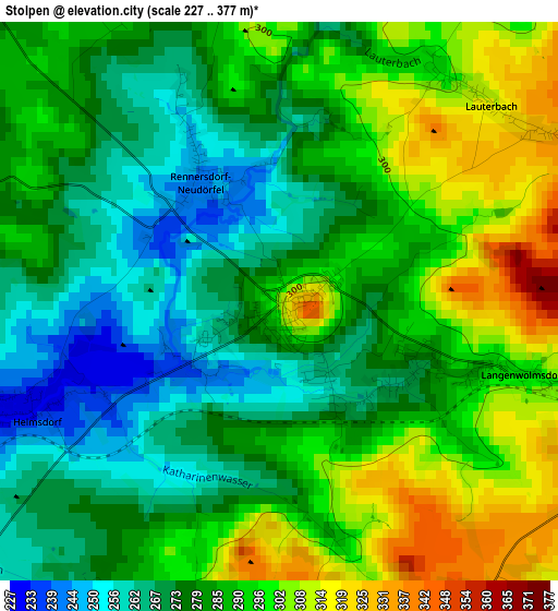
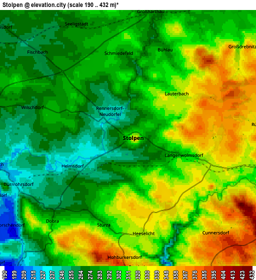
Below is the Elevation map of Stolpen, which displays elevation range with different colors. Scale of the first map is from 227 to 377 m (745 to 1237 ft) with average elevation of 284.9 meters (=935 ft) [note 1]
These maps also provides idea of topography and contour of this city, they are displayed at different zoom levels. More info about maps, scale and edge coordinates you can find below images.
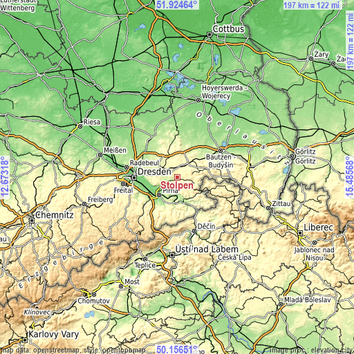
| \ | Map #1 | Map #2 | Topo.Map |
| Scale [m] | 227..377 m | 190..432 m | × |
| Scale [ft] | 745..1237 ft | 623..1417 ft | × |
| Average | 284.9 m = 935 ft | 299.3 m = 982 ft | × |
| Width | 6.14 km = 3.8 mi | 12.29 km = 7.6 mi | 196.6 km = 122.2 mi |
| Height | 6.14 km = 3.8 mi | 12.29 km = 7.6 mi | 196.6 km = 122.2 mi |
| ↑Max Latitude | 51.076628° | 51.10423° | 51.92464° |
| Latitude at center | 51.04901° | 51.04901° | 51.04901° |
| ↓Min Latitude | 51.021375° | 50.993724° | 50.15651° |
| ← Min Longitude | 14.035485° | 13.991539° | 12.67318° |
| Longitude center | 14.07943° | 14.07943° | 14.07943° |
| →Max Longitude | 14.123375° | 14.167321° | 15.48568° |
Nearby cities:
Cities around Stolpen sort by population:
• Neustadt in Sachsen elevation 327 m
9.9 km,  103°
103°
• Bischofswerda 293 m
11.2 km,  38°
38°
• Großröhrsdorf 271 m
11.5 km,  338°
338°
• Dürrröhrsdorf 223 m
6 km,  253°
253°
• Hohnstein 317 m
8.1 km,  162°
162°
• Großharthau 278 m
6.6 km,  12°
12°
• Lohmen 206 m
8.6 km,  218°
218°
• Hauswalde 300 m
11.5 km,  2°
2°
• Berthelsdorf 336 m
10 km,  91°
91°
• Stadt Wehlen 163 m
10.7 km,  198°
198°
• Rammenau 303 m
11.8 km,  18°
18°
• Frankenthal 300 m
9.4 km, 12°
Multilingual:
 En español:
Stolpen elevación 305 m.
 En France:
Stolpen élévation 305 m.


Sources and notes:
- [note 1] Map square and city borders are not equal. Map elevation data is calculated only from area inside that square.
- [src 1] Elevation data from geonames database provided with same terms of usage.
- [src 2] The elevation map of Stolpen is generated using elevation data from NASA's 3 arcsec (90m) resolution SRTM data.
- [src 3] Base (background) map © OpenStreetMap contributors tiles are generated by Geofabrik and OpenTopoMap.
Copyright & License:
This Stolpen Elevation Map is licensed under CC BY-SA. You may reuse any part from this page, if you give a proper credit by linking to this URL:
 More info on terms of use page.