Bischofswerda elevation
Bischofswerda (Saxony), Germany elevation is 293 meters and Bischofswerda elevation in feet is 961 ft above sea level [src 1]. Bischofswerda is a populated place (feature code) with elevation that is 35 meters (115 ft) bigger than average city elevation in Germany.
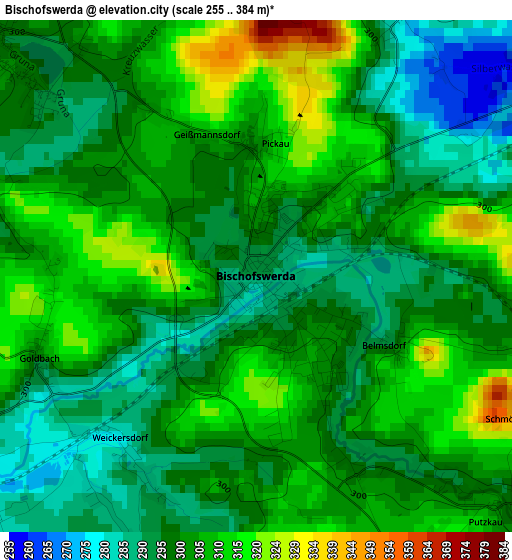
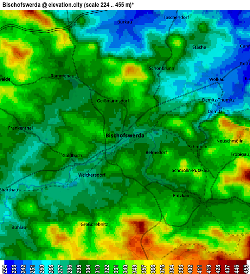
Below is the Elevation map of Bischofswerda, which displays elevation range with different colors. Scale of the first map is from 255 to 384 m (837 to 1260 ft) with average elevation of 300.9 meters (=987 ft) [note 1]
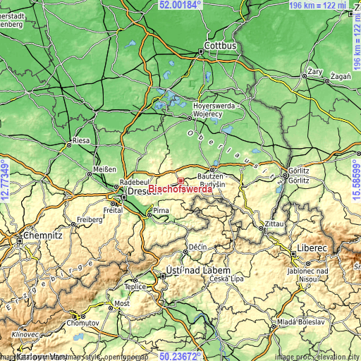
These maps also provides idea of topography and contour of this city, they are displayed at different zoom levels. More info about maps, scale and edge coordinates you can find below images.
| \ | Map #1 | Map #2 | Topo.Map |
| Scale [m] | 255..384 m | 224..455 m | × |
| Scale [ft] | 837..1260 ft | 735..1493 ft | × |
| Average | 300.9 m = 987 ft | 307.7 m = 1010 ft | × |
| Width | 6.13 km = 3.8 mi | 12.27 km = 7.6 mi | 196.3 km = 122 mi |
| Height | 6.13 km = 3.8 mi | 12.27 km = 7.6 mi | 196.2 km = 121.9 mi |
| ↑Max Latitude | 51.155281° | 51.182836° | 52.00184° |
| Latitude at center | 51.12771° | 51.12771° | 51.12771° |
| ↓Min Latitude | 51.100122° | 51.072518° | 50.23672° |
| ← Min Longitude | 14.135795° | 14.091849° | 12.77349° |
| Longitude center | 14.17974° | 14.17974° | 14.17974° |
| →Max Longitude | 14.223685° | 14.267631° | 15.58599° |
Nearby cities:
Cities around Bischofswerda sort by population:
• Stolpen elevation 305 m
11.2 km,  218°
218°
• Neukirch/Lausitz 322 m
9.6 km,  110°
110°
• Göda 209 m
11.2 km,  60°
60°
• Großharthau 278 m
6.1 km,  247°
247°
• Hauswalde 300 m
7.1 km,  292°
292°
• Elstra 220 m
11 km,  342°
342°
• Demitz-Thumitz 247 m
4.9 km,  71°
71°
• Burkau 239 m
5.4 km,  355°
355°
• Ohorn 318 m
10.5 km,  297°
297°
• Berthelsdorf 336 m
9.5 km,  161°
161°
• Rammenau 303 m
4.1 km,  307°
307°
• Frankenthal 300 m
5 km,  274°
274°
Multilingual:
 En español:
Bischofswerda elevación 293 m.
 En France:
Bischofswerda élévation 293 m.
 Auf Deutsch:
Bischofswerda höhe über dem Meeresspiegel ist 293 m.

Sources and notes:
- [note 1] Map square and city borders are not equal. Map elevation data is calculated only from area inside that square.
- [src 1] Elevation data from geonames database provided with same terms of usage.
- [src 2] The elevation map of Bischofswerda is generated using elevation data from NASA's 3 arcsec (90m) resolution SRTM data.
- [src 3] Base (background) map © OpenStreetMap contributors tiles are generated by Geofabrik and OpenTopoMap.
Copyright & License:
This Bischofswerda Elevation Map is licensed under CC BY-SA. You may reuse any part from this page, if you give a proper credit by linking to this URL:
 More info on terms of use page.