Stühlingen elevation
Stühlingen (Baden-Württemberg, Freiburg Region), Germany elevation is 454 meters and Stühlingen elevation in feet is 1490 ft above sea level [src 1]. Stühlingen is a populated place (feature code) with elevation that is 196 meters (643 ft) bigger than average city elevation in Germany.
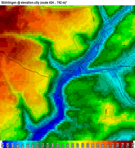
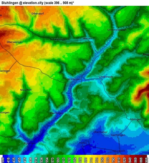
Below is the Elevation map of Stühlingen, which displays elevation range with different colors. Scale of the first map is from 424 to 742 m (1391 to 2434 ft) with average elevation of 571.4 meters (=1875 ft) [note 1]
These maps also provides idea of topography and contour of this city, they are displayed at different zoom levels. More info about maps, scale and edge coordinates you can find below images.
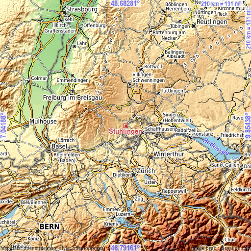
| \ | Map #1 | Map #2 | Topo.Map |
| Scale [m] | 424..742 m | 396..908 m | × |
| Scale [ft] | 1391..2434 ft | 1299..2979 ft | × |
| Average | 571.4 m = 1875 ft | 593.4 m = 1947 ft | × |
| Width | 6.57 km = 4.1 mi | 13.14 km = 8.2 mi | 210.3 km = 130.7 mi |
| Height | 6.57 km = 4.1 mi | 13.14 km = 8.2 mi | 210.3 km = 130.7 mi |
| ↑Max Latitude | 47.775341° | 47.804866° | 48.68281° |
| Latitude at center | 47.7458° | 47.7458° | 47.7458° |
| ↓Min Latitude | 47.716242° | 47.686667° | 46.79161° |
| ← Min Longitude | 8.404185° | 8.360239° | 7.04188° |
| Longitude center | 8.44813° | 8.44813° | 8.44813° |
| →Max Longitude | 8.492075° | 8.536021° | 9.85438° |
Nearby cities:
Cities around Stühlingen sort by population:
• Blumberg elevation 699 m
12.3 km,  31°
31°
• Löffingen 801 m
17.2 km,  333°
333°
• Staufen 942 m
17.8 km,  273°
273°
• Lauchringen 349 m
16.6 km,  217°
217°
• Bonndorf 834 m
11.4 km,  315°
315°
• Wutöschingen 387 m
11.3 km,  212°
212°
• Ühlingen-Birkendorf 637 m
10.4 km,  251°
251°
• Jestetten 429 m
13.9 km,  140°
140°
• Tengen 639 m
18 km,  62°
62°
• Lottstetten 495 m
15.3 km, 144°
• Eggingen 434 m
6.2 km, 215°
• Dettighofen 488 m
13.9 km,  168°
168°
Multilingual:
 En español:
Stühlingen elevación 454 m.
 En France:
Stühlingen élévation 454 m.
 Auf Deutsch:
Stühlingen höhe über dem Meeresspiegel ist 454 m.

Sources and notes:
- [note 1] Map square and city borders are not equal. Map elevation data is calculated only from area inside that square.
- [src 1] Elevation data from geonames database provided with same terms of usage.
- [src 2] The elevation map of Stühlingen is generated using elevation data from NASA's 3 arcsec (90m) resolution SRTM data.
- [src 3] Base (background) map © OpenStreetMap contributors tiles are generated by Geofabrik and OpenTopoMap.
Copyright & License:
This Stühlingen Elevation Map is licensed under CC BY-SA. You may reuse any part from this page, if you give a proper credit by linking to this URL:
 More info on terms of use page.