Talheim elevation
Talheim (Baden-Württemberg, Freiburg Region), Germany elevation is 827 meters and Talheim elevation in feet is 2713 ft above sea level [src 1]. Talheim is a seat of a fourth-order administrative division (feature code) with elevation that is 569 meters (1867 ft) bigger than average city elevation in Germany.
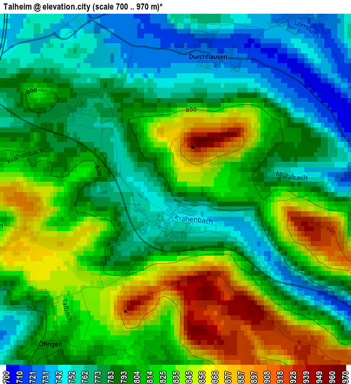
Below is the Elevation map of Talheim, which displays elevation range with different colors. Scale of the first map is from 700 to 970 m (2297 to 3182 ft) with average elevation of 804 meters (=2638 ft) [note 1]
These maps also provides idea of topography and contour of this city, they are displayed at different zoom levels. More info about maps, scale and edge coordinates you can find below images.
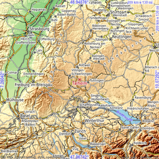
| \ | Map #1 | Topo.Map |
| Scale [m] | 700..970 m | × |
| Scale [ft] | 2297..3182 ft | × |
| Average | 804 m = 2638 ft | × |
| Width | 6.54 km = 4.1 mi | 209.2 km = 130 mi |
| Height | 6.54 km = 4.1 mi | 209.2 km = 130 mi |
| ↑Max Latitude | 48.046057° | 48.94876° |
| Latitude at center | 48.01667° | 48.01667° |
| ↓Min Latitude | 47.987266° | 47.06742° |
| ← Min Longitude | 8.622725° | 7.26042° |
| Longitude center | 8.66667° | 8.66667° |
| →Max Longitude | 8.710615° | 10.07292° |
Nearby cities:
Cities around Talheim sort by population:
• Trossingen elevation 687 m
6.9 km,  345°
345°
• Bad Dürrheim 700 m
10.1 km,  272°
272°
• Spaichingen 657 m
8.2 km,  38°
38°
• Aldingen 644 m
9.6 km,  14°
14°
• Deißlingen 601 m
11.5 km,  337°
337°
• Geisingen 680 m
10.3 km,  186°
186°
• Immendingen 660 m
10.5 km,  151°
151°
• Wurmlingen 677 m
8.9 km,  102°
102°
• Tuningen 759 m
5.3 km,  290°
290°
• Rietheim-Weilheim 760 m
7.4 km,  90°
90°
• Seitingen-Oberflacht 715 m
3.7 km, 90°
• Dürbheim 718 m
10.4 km,  64°
64°
Multilingual:
 En español:
Talheim elevación 827 m.
 En France:
Talheim élévation 827 m.


Sources and notes:
- [note 1] Map square and city borders are not equal. Map elevation data is calculated only from area inside that square.
- [src 1] Elevation data from geonames database provided with same terms of usage.
- [src 2] The elevation map of Talheim is generated using elevation data from NASA's 3 arcsec (90m) resolution SRTM data.
- [src 3] Base (background) map © OpenStreetMap contributors tiles are generated by Geofabrik and OpenTopoMap.
Copyright & License:
This Talheim Elevation Map is licensed under CC BY-SA. You may reuse any part from this page, if you give a proper credit by linking to this URL:
 More info on terms of use page.