Spaichingen elevation
Spaichingen (Baden-Württemberg, Freiburg Region), Germany elevation is 657 meters and Spaichingen elevation in feet is 2156 ft above sea level [src 1]. Spaichingen is a populated place (feature code) with elevation that is 399 meters (1309 ft) bigger than average city elevation in Germany.
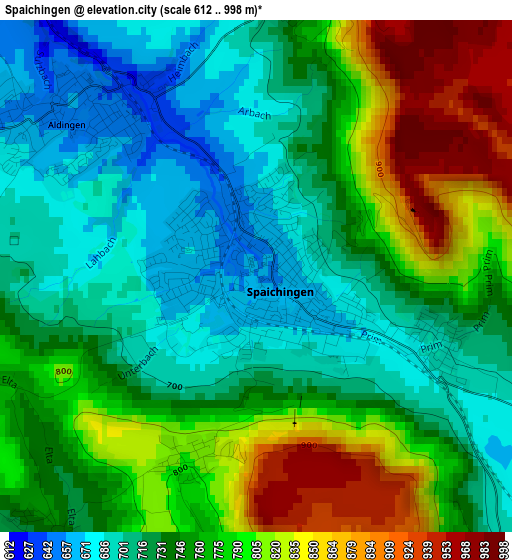
Below is the Elevation map of Spaichingen, which displays elevation range with different colors. Scale of the first map is from 612 to 998 m (2008 to 3274 ft) with average elevation of 754.4 meters (=2475 ft) [note 1]
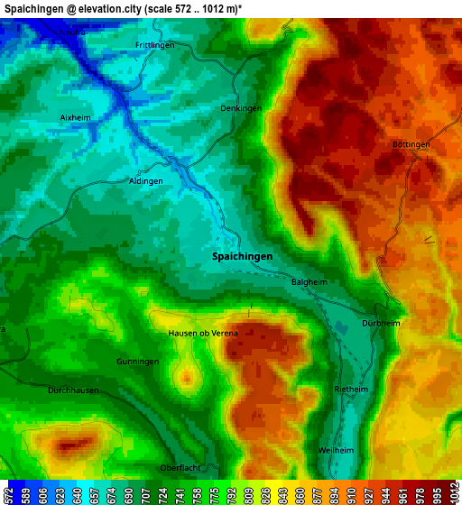
These maps also provides idea of topography and contour of this city, they are displayed at different zoom levels. More info about maps, scale and edge coordinates you can find below images.
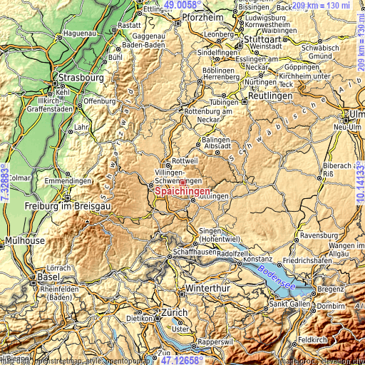
| \ | Map #1 | Map #2 | Topo.Map |
| Scale [m] | 612..998 m | 572..1012 m | × |
| Scale [ft] | 2008..3274 ft | 1877..3320 ft | × |
| Average | 754.4 m = 2475 ft | 780.9 m = 2562 ft | × |
| Width | 6.53 km = 4.1 mi | 13.06 km = 8.1 mi | 208.9 km = 129.8 mi |
| Height | 6.53 km = 4.1 mi | 13.06 km = 8.1 mi | 208.9 km = 129.8 mi |
| ↑Max Latitude | 48.104124° | 48.133462° | 49.0058° |
| Latitude at center | 48.07477° | 48.07477° | 48.07477° |
| ↓Min Latitude | 48.045399° | 48.016011° | 47.12658° |
| ← Min Longitude | 8.691135° | 8.647189° | 7.32883° |
| Longitude center | 8.73508° | 8.73508° | 8.73508° |
| →Max Longitude | 8.779025° | 8.822971° | 10.14133° |
Nearby cities:
Cities around Spaichingen sort by population:
• Trossingen elevation 687 m
6.8 km,  271°
271°
• Aldingen 644 m
3.8 km,  317°
317°
• Gosheim 849 m
6.8 km,  12°
12°
• Wellendingen 633 m
8.4 km,  343°
343°
• Rietheim-Weilheim 760 m
6.9 km,  160°
160°
• Denkingen 682 m
4 km,  3°
3°
• Seitingen-Oberflacht 715 m
6.6 km,  191°
191°
• Frittlingen 647 m
6.2 km, 340°
• Dürbheim 718 m
4.8 km,  115°
115°
• Böttingen 942 m
5.6 km,  59°
59°
• Talheim 827 m
8.2 km,  218°
218°
• Bubsheim 913 m
8.7 km, 57°
Multilingual:
 En español:
Spaichingen elevación 657 m.
 En France:
Spaichingen élévation 657 m.
 Auf Deutsch:
Spaichingen höhe über dem Meeresspiegel ist 657 m.

Sources and notes:
- [note 1] Map square and city borders are not equal. Map elevation data is calculated only from area inside that square.
- [src 1] Elevation data from geonames database provided with same terms of usage.
- [src 2] The elevation map of Spaichingen is generated using elevation data from NASA's 3 arcsec (90m) resolution SRTM data.
- [src 3] Base (background) map © OpenStreetMap contributors tiles are generated by Geofabrik and OpenTopoMap.
Copyright & License:
This Spaichingen Elevation Map is licensed under CC BY-SA. You may reuse any part from this page, if you give a proper credit by linking to this URL:
 More info on terms of use page.