Geisingen elevation
Geisingen (Baden-Württemberg, Freiburg Region), Germany elevation is 680 meters and Geisingen elevation in feet is 2231 ft above sea level [src 1]. Geisingen is a populated place (feature code) with elevation that is 422 meters (1385 ft) bigger than average city elevation in Germany.
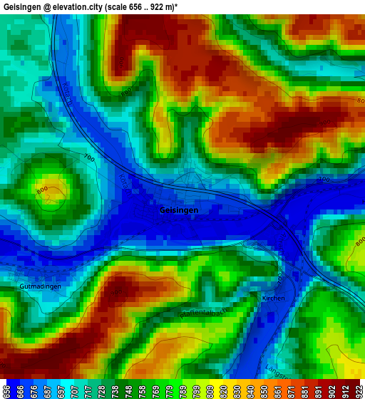
Below is the Elevation map of Geisingen, which displays elevation range with different colors. Scale of the first map is from 656 to 922 m (2152 to 3025 ft) with average elevation of 760.6 meters (=2495 ft) [note 1]
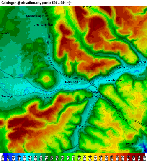
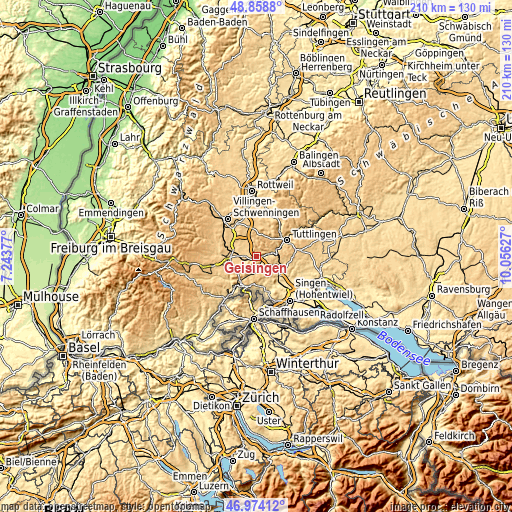
These maps also provides idea of topography and contour of this city, they are displayed at different zoom levels. More info about maps, scale and edge coordinates you can find below images.
| \ | Map #1 | Map #2 | Topo.Map |
| Scale [m] | 656..922 m | 599..951 m | × |
| Scale [ft] | 2152..3025 ft | 1965..3120 ft | × |
| Average | 760.6 m = 2495 ft | 769.7 m = 2525 ft | × |
| Width | 6.55 km = 4.1 mi | 13.1 km = 8.1 mi | 209.6 km = 130.2 mi |
| Height | 6.55 km = 4.1 mi | 13.1 km = 8.1 mi | 209.5 km = 130.2 mi |
| ↑Max Latitude | 47.954479° | 47.983902° | 48.8588° |
| Latitude at center | 47.92504° | 47.92504° | 47.92504° |
| ↓Min Latitude | 47.895584° | 47.866111° | 46.97412° |
| ← Min Longitude | 8.606075° | 8.562129° | 7.24377° |
| Longitude center | 8.65002° | 8.65002° | 8.65002° |
| →Max Longitude | 8.693965° | 8.737911° | 10.05627° |
Nearby cities:
Cities around Geisingen sort by population:
• Donaueschingen elevation 701 m
11.9 km,  286°
286°
• Blumberg 699 m
12.8 km,  222°
222°
• Engen 530 m
12 km,  130°
130°
• Hüfingen 687 m
12 km,  270°
270°
• Immendingen 660 m
6.3 km,  81°
81°
• Tengen 639 m
11.6 km,  175°
175°
• Neuhausen 496 m
13.4 km,  136°
136°
• Wurmlingen 677 m
13 km,  49°
49°
• Tuningen 759 m
12.6 km,  342°
342°
• Rietheim-Weilheim 760 m
13.4 km,  40°
40°
• Seitingen-Oberflacht 715 m
11.3 km,  25°
25°
• Talheim 827 m
10.3 km,  6°
6°
Multilingual:
 En español:
Geisingen elevación 680 m.
 En France:
Geisingen élévation 680 m.
 Auf Deutsch:
Geisingen höhe über dem Meeresspiegel ist 680 m.

Sources and notes:
- [note 1] Map square and city borders are not equal. Map elevation data is calculated only from area inside that square.
- [src 1] Elevation data from geonames database provided with same terms of usage.
- [src 2] The elevation map of Geisingen is generated using elevation data from NASA's 3 arcsec (90m) resolution SRTM data.
- [src 3] Base (background) map © OpenStreetMap contributors tiles are generated by Geofabrik and OpenTopoMap.
Copyright & License:
This Geisingen Elevation Map is licensed under CC BY-SA. You may reuse any part from this page, if you give a proper credit by linking to this URL:
 More info on terms of use page.