Türkheim elevation
Türkheim (Bavaria, Swabia), Germany elevation is 599 meters and Türkheim elevation in feet is 1965 ft above sea level [src 1]. Türkheim is a populated place (feature code) with elevation that is 341 meters (1119 ft) bigger than average city elevation in Germany.
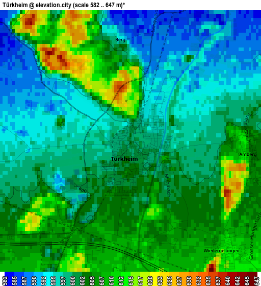
Below is the Elevation map of Türkheim, which displays elevation range with different colors. Scale of the first map is from 582 to 647 m (1909 to 2123 ft) with average elevation of 601.1 meters (=1972 ft) [note 1]
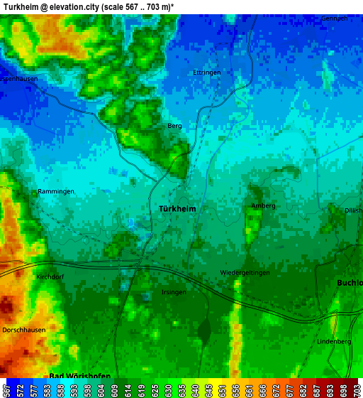
These maps also provides idea of topography and contour of this city, they are displayed at different zoom levels. More info about maps, scale and edge coordinates you can find below images.
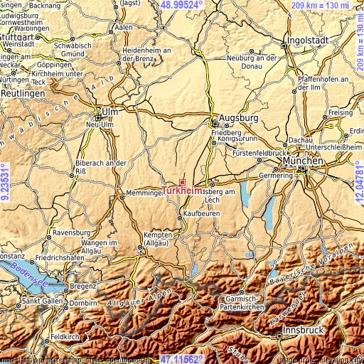
| \ | Map #1 | Map #2 | Topo.Map |
| Scale [m] | 582..647 m | 567..703 m | × |
| Scale [ft] | 1909..2123 ft | 1860..2306 ft | × |
| Average | 601.1 m = 1972 ft | 606.5 m = 1990 ft | × |
| Width | 6.53 km = 4.1 mi | 13.06 km = 8.1 mi | 209 km = 129.9 mi |
| Height | 6.53 km = 4.1 mi | 13.06 km = 8.1 mi | 209 km = 129.9 mi |
| ↑Max Latitude | 48.09337° | 48.122714° | 48.99524° |
| Latitude at center | 48.06401° | 48.06401° | 48.06401° |
| ↓Min Latitude | 48.034633° | 48.005239° | 47.11562° |
| ← Min Longitude | 10.597615° | 10.553669° | 9.23531° |
| Longitude center | 10.64156° | 10.64156° | 10.64156° |
| →Max Longitude | 10.685505° | 10.729451° | 12.04781° |
Nearby cities:
Cities around Türkheim sort by population:
• Mindelheim elevation 604 m
11.3 km,  259°
259°
• Bad Wörishofen 625 m
7.2 km,  207°
207°
• Buchloe 615 m
6.9 km,  115°
115°
• Ettringen 583 m
4.1 km,  8°
8°
• Tussenhausen 577 m
7.4 km,  305°
305°
• Jengen 637 m
9.5 km,  138°
138°
• Markt Wald 636 m
9.2 km,  331°
331°
• Dirlewang 626 m
12.4 km,  236°
236°
• Lamerdingen 597 m
7.9 km,  66°
66°
• Hiltenfingen 558 m
12.2 km,  27°
27°
• Wiedergeltingen 612 m
3.6 km, 138°
• Amberg 599 m
3.1 km,  84°
84°
Multilingual:
 En español:
Türkheim elevación 599 m.
 En France:
Türkheim élévation 599 m.
 Auf Deutsch:
Türkheim höhe über dem Meeresspiegel ist 599 m.

Sources and notes:
- [note 1] Map square and city borders are not equal. Map elevation data is calculated only from area inside that square.
- [src 1] Elevation data from geonames database provided with same terms of usage.
- [src 2] The elevation map of Türkheim is generated using elevation data from NASA's 3 arcsec (90m) resolution SRTM data.
- [src 3] Base (background) map © OpenStreetMap contributors tiles are generated by Geofabrik and OpenTopoMap.
Copyright & License:
This Türkheim Elevation Map is licensed under CC BY-SA. You may reuse any part from this page, if you give a proper credit by linking to this URL:
 More info on terms of use page.