Mindelheim elevation
Mindelheim (Bavaria, Swabia), Germany elevation is 604 meters and Mindelheim elevation in feet is 1982 ft above sea level [src 1]. Mindelheim is a seat of a third-order administrative division (feature code) with elevation that is 346 meters (1135 ft) bigger than average city elevation in Germany.
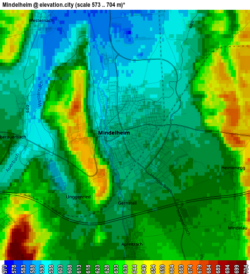
Below is the Elevation map of Mindelheim, which displays elevation range with different colors. Scale of the first map is from 573 to 704 m (1880 to 2310 ft) with average elevation of 618.2 meters (=2028 ft) [note 1]
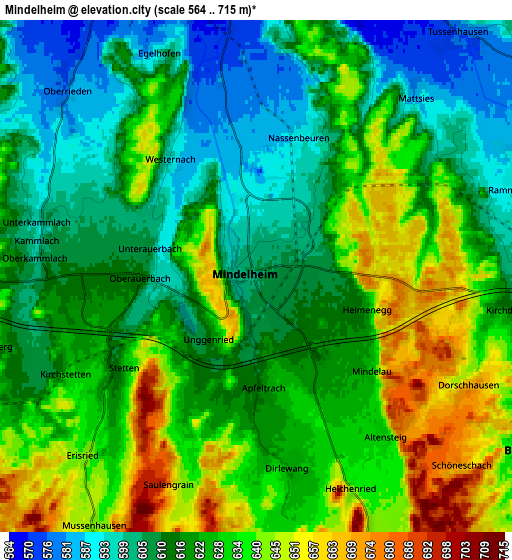
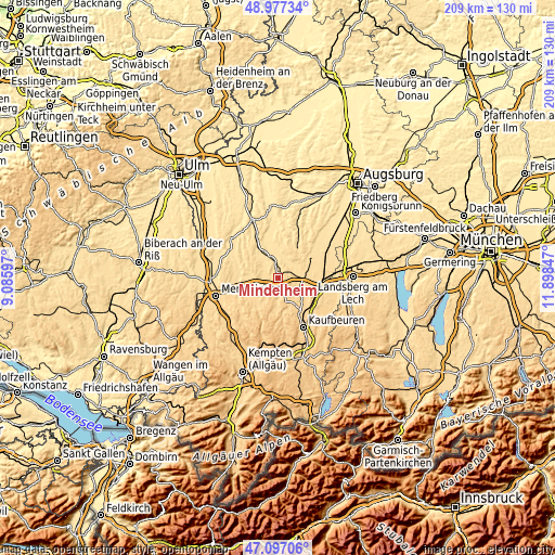
These maps also provides idea of topography and contour of this city, they are displayed at different zoom levels. More info about maps, scale and edge coordinates you can find below images.
| \ | Map #1 | Map #2 | Topo.Map |
| Scale [m] | 573..704 m | 564..715 m | × |
| Scale [ft] | 1880..2310 ft | 1850..2346 ft | × |
| Average | 618.2 m = 2028 ft | 622.7 m = 2043 ft | × |
| Width | 6.53 km = 4.1 mi | 13.07 km = 8.1 mi | 209.1 km = 129.9 mi |
| Height | 6.53 km = 4.1 mi | 13.07 km = 8.1 mi | 209.1 km = 129.9 mi |
| ↑Max Latitude | 48.075151° | 48.104505° | 48.97734° |
| Latitude at center | 48.04578° | 48.04578° | 48.04578° |
| ↓Min Latitude | 48.016393° | 47.986988° | 47.09706° |
| ← Min Longitude | 10.448275° | 10.404329° | 9.08597° |
| Longitude center | 10.49222° | 10.49222° | 10.49222° |
| →Max Longitude | 10.536165° | 10.580111° | 11.89847° |
Nearby cities:
Cities around Mindelheim sort by population:
• Bad Wörishofen elevation 625 m
8.9 km,  119°
119°
• Türkheim 599 m
11.3 km,  79°
79°
• Erkheim 598 m
11.7 km,  265°
265°
• Tussenhausen 577 m
8.1 km,  39°
39°
• Sontheim 620 m
11.1 km,  247°
247°
• Pfaffenhausen 564 m
8.6 km,  341°
341°
• Dirlewang 626 m
4.9 km,  170°
170°
• Salgen 559 m
9.5 km,  354°
354°
• Unteregg 688 m
9 km,  192°
192°
• Stetten 619 m
4.3 km,  235°
235°
• Baisweil 678 m
11.8 km,  162°
162°
• Oberrieden 576 m
6.9 km,  314°
314°
Multilingual:
 En español:
Mindelheim elevación 604 m.
 En France:
Mindelheim élévation 604 m.
 Auf Deutsch:
Mindelheim höhe über dem Meeresspiegel ist 604 m.

Sources and notes:
- [note 1] Map square and city borders are not equal. Map elevation data is calculated only from area inside that square.
- [src 1] Elevation data from geonames database provided with same terms of usage.
- [src 2] The elevation map of Mindelheim is generated using elevation data from NASA's 3 arcsec (90m) resolution SRTM data.
- [src 3] Base (background) map © OpenStreetMap contributors tiles are generated by Geofabrik and OpenTopoMap.
Copyright & License:
This Mindelheim Elevation Map is licensed under CC BY-SA. You may reuse any part from this page, if you give a proper credit by linking to this URL:
 More info on terms of use page.