Türnich elevation
Türnich (North Rhine-Westphalia, Regierungsbezirk Köln), Germany elevation is 98 meters and Türnich elevation in feet is 322 ft above sea level [src 1]. Türnich is a populated place (feature code) with elevation that is 160 meters (525 ft) smaller than average city elevation in Germany.
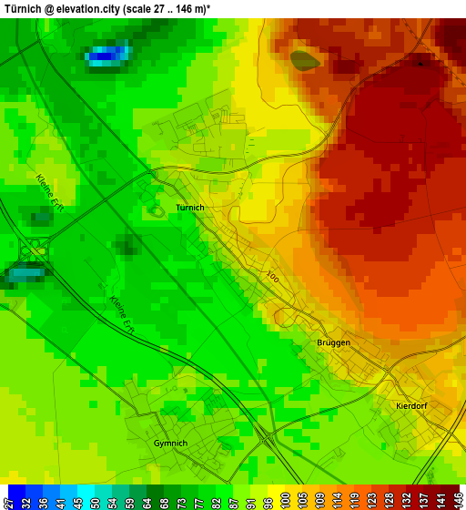
Below is the Elevation map of Türnich, which displays elevation range with different colors. Scale of the first map is from 27 to 146 m (89 to 479 ft) with average elevation of 97.2 meters (=319 ft) [note 1]
These maps also provides idea of topography and contour of this city, they are displayed at different zoom levels. More info about maps, scale and edge coordinates you can find below images.
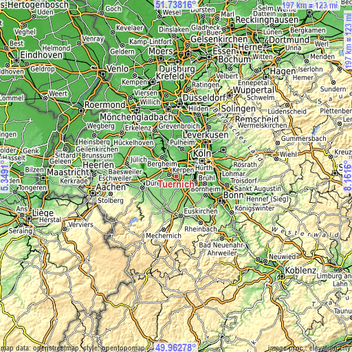
| \ | Map #1 | Topo.Map |
| Scale [m] | 27..146 m | × |
| Scale [ft] | 89..479 ft | × |
| Average | 97.2 m = 319 ft | × |
| Width | 6.17 km = 3.8 mi | 197.4 km = 122.7 mi |
| Height | 6.17 km = 3.8 mi | 197.4 km = 122.7 mi |
| ↑Max Latitude | 50.886651° | 51.73816° |
| Latitude at center | 50.85892° | 50.85892° |
| ↓Min Latitude | 50.831172° | 49.96278° |
| ← Min Longitude | 6.711405° | 5.3491° |
| Longitude center | 6.75535° | 6.75535° |
| →Max Longitude | 6.799295° | 8.1616° |
Nearby cities:
Cities around Türnich sort by population:
• Kerpen elevation 84 m
4.3 km,  286°
286°
• Bergheim 67 m
13.5 km,  323°
323°
• Hürth 91 m
8 km,  80°
80°
• Erftstadt 94 m
5.6 km,  151°
151°
• Frechen 73 m
7.4 km,  32°
32°
• Brühl 68 m
11 km,  107°
107°
• Neustadt/Süd 55 m
15.4 km,  61°
61°
• Wesseling 50 m
15.8 km,  102°
102°
• Elsdorf 78 m
15.8 km,  303°
303°
• Weilerswist 120 m
13.4 km, 151°
• Nörvenich 119 m
10 km,  234°
234°
• Mengenich 52 m
15.4 km, 30°
Multilingual:
 En español:
Türnich elevación 98 m.
 En France:
Türnich élévation 98 m.


Sources and notes:
- [note 1] Map square and city borders are not equal. Map elevation data is calculated only from area inside that square.
- [src 1] Elevation data from geonames database provided with same terms of usage.
- [src 2] The elevation map of Türnich is generated using elevation data from NASA's 3 arcsec (90m) resolution SRTM data.
- [src 3] Base (background) map © OpenStreetMap contributors tiles are generated by Geofabrik and OpenTopoMap.
Copyright & License:
This Türnich Elevation Map is licensed under CC BY-SA. You may reuse any part from this page, if you give a proper credit by linking to this URL:
 More info on terms of use page.