Frechen elevation
Frechen (North Rhine-Westphalia, Regierungsbezirk Köln), Germany elevation is 73 meters and Frechen elevation in feet is 240 ft above sea level [src 1]. Frechen is a populated place (feature code) with elevation that is 185 meters (607 ft) smaller than average city elevation in Germany.
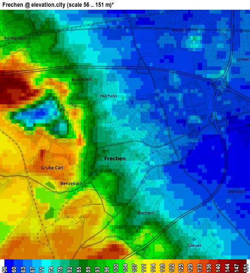
Below is the Elevation map of Frechen, which displays elevation range with different colors. Scale of the first map is from 56 to 151 m (184 to 495 ft) with average elevation of 83.9 meters (=275 ft) [note 1]
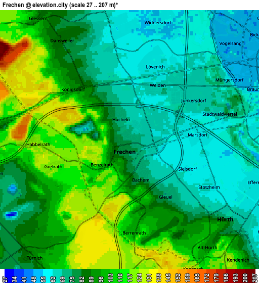
These maps also provides idea of topography and contour of this city, they are displayed at different zoom levels. More info about maps, scale and edge coordinates you can find below images.
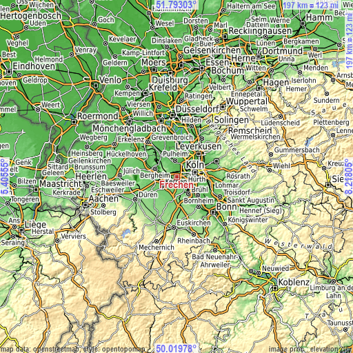
| \ | Map #1 | Map #2 | Topo.Map |
| Scale [m] | 56..151 m | 27..207 m | × |
| Scale [ft] | 184..495 ft | 89..679 ft | × |
| Average | 83.9 m = 275 ft | 87.2 m = 286 ft | × |
| Width | 6.16 km = 3.8 mi | 12.32 km = 7.7 mi | 197.2 km = 122.5 mi |
| Height | 6.16 km = 3.8 mi | 12.32 km = 7.7 mi | 197.2 km = 122.5 mi |
| ↑Max Latitude | 50.942548° | 50.97023° | 51.79303° |
| Latitude at center | 50.91485° | 50.91485° | 50.91485° |
| ↓Min Latitude | 50.887135° | 50.859404° | 50.01978° |
| ← Min Longitude | 6.767855° | 6.723909° | 5.40555° |
| Longitude center | 6.8118° | 6.8118° | 6.8118° |
| →Max Longitude | 6.855745° | 6.899691° | 8.21805° |
Nearby cities:
Cities around Frechen sort by population:
• Köln elevation 58 m
9.9 km,  78°
78°
• Kerpen 84 m
9.5 km,  238°
238°
• Hürth 91 m
6.3 km,  141°
141°
• Pulheim 47 m
9.4 km,  357°
357°
• Neustadt/Süd 55 m
9.6 km, 83°
• Neustadt/Nord 51 m
10.3 km,  68°
68°
• Neuehrenfeld 49 m
9.9 km,  61°
61°
• Altstadt Nord 59 m
10.6 km, 75°
• Bilderstoeckchen 51 m
10.3 km,  53°
53°
• Ossendorf 49 m
9.1 km, 46°
• Mengenich 52 m
8.1 km,  28°
28°
• Türnich 98 m
7.4 km,  212°
212°
Multilingual:
 En español:
Frechen elevación 73 m.
 En France:
Frechen élévation 73 m.


Sources and notes:
- [note 1] Map square and city borders are not equal. Map elevation data is calculated only from area inside that square.
- [src 1] Elevation data from geonames database provided with same terms of usage.
- [src 2] The elevation map of Frechen is generated using elevation data from NASA's 3 arcsec (90m) resolution SRTM data.
- [src 3] Base (background) map © OpenStreetMap contributors tiles are generated by Geofabrik and OpenTopoMap.
Copyright & License:
This Frechen Elevation Map is licensed under CC BY-SA. You may reuse any part from this page, if you give a proper credit by linking to this URL:
 More info on terms of use page.