Waldkirchen elevation
Waldkirchen (Saxony), Germany elevation is 427 meters and Waldkirchen elevation in feet is 1401 ft above sea level [src 1]. Waldkirchen is a populated place (feature code) with elevation that is 169 meters (554 ft) bigger than average city elevation in Germany.
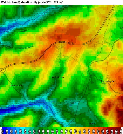
Below is the Elevation map of Waldkirchen, which displays elevation range with different colors. Scale of the first map is from 352 to 519 m (1155 to 1703 ft) with average elevation of 434.1 meters (=1424 ft) [note 1]
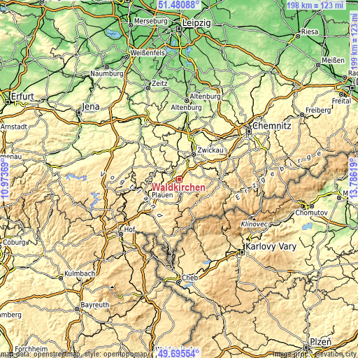
These maps also provides idea of topography and contour of this city, they are displayed at different zoom levels. More info about maps, scale and edge coordinates you can find below images.
| \ | Map #1 | Topo.Map |
| Scale [m] | 352..519 m | × |
| Scale [ft] | 1155..1703 ft | × |
| Average | 434.1 m = 1424 ft | × |
| Width | 6.2 km = 3.9 mi | 198.5 km = 123.3 mi |
| Height | 6.2 km = 3.9 mi | 198.5 km = 123.3 mi |
| ↑Max Latitude | 50.624557° | 51.48088° |
| Latitude at center | 50.59667° | 50.59667° |
| ↓Min Latitude | 50.568766° | 49.69554° |
| ← Min Longitude | 12.335995° | 10.97369° |
| Longitude center | 12.37994° | 12.37994° |
| →Max Longitude | 12.423885° | 13.78619° |
Nearby cities:
Cities around Waldkirchen sort by population:
• Reichenbach/Vogtland elevation 381 m
6.1 km,  298°
298°
• Auerbach 458 m
9.6 km,  171°
171°
• Kirchberg 351 m
10.6 km,  74°
74°
• Treuen 465 m
8.1 km,  221°
221°
• Lengenfeld 393 m
3.2 km,  200°
200°
• Rodewisch 434 m
7.7 km,  162°
162°
• Lichtentanne 325 m
11.1 km,  16°
16°
• Netzschkau 379 m
9.8 km,  281°
281°
• Neumark 354 m
7.2 km,  346°
346°
• Mylau 319 m
8.4 km,  286°
286°
• Limbach 407 m
9.3 km,  260°
260°
• Hirschfeld 402 m
6.3 km,  60°
60°
Multilingual:
 En español:
Waldkirchen elevación 427 m.
 En France:
Waldkirchen élévation 427 m.
 Auf Deutsch:
Waldkirchen höhe über dem Meeresspiegel ist 427 m.

Sources and notes:
- [note 1] Map square and city borders are not equal. Map elevation data is calculated only from area inside that square.
- [src 1] Elevation data from geonames database provided with same terms of usage.
- [src 2] The elevation map of Waldkirchen is generated using elevation data from NASA's 3 arcsec (90m) resolution SRTM data.
- [src 3] Base (background) map © OpenStreetMap contributors tiles are generated by Geofabrik and OpenTopoMap.
Copyright & License:
This Waldkirchen Elevation Map is licensed under CC BY-SA. You may reuse any part from this page, if you give a proper credit by linking to this URL:
 More info on terms of use page.