Wasungen elevation
Wasungen (Thuringia), Germany elevation is 273 meters and Wasungen elevation in feet is 896 ft above sea level [src 1]. Wasungen is a populated place (feature code) with elevation that is 15 meters (49 ft) bigger than average city elevation in Germany.
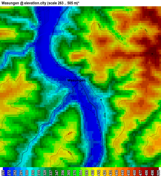
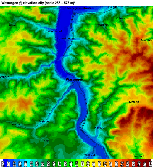
Below is the Elevation map of Wasungen, which displays elevation range with different colors. Scale of the first map is from 263 to 505 m (863 to 1657 ft) with average elevation of 365.2 meters (=1198 ft) [note 1]
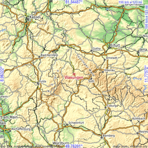
These maps also provides idea of topography and contour of this city, they are displayed at different zoom levels. More info about maps, scale and edge coordinates you can find below images.
| \ | Map #1 | Map #2 | Topo.Map |
| Scale [m] | 263..505 m | 255..573 m | × |
| Scale [ft] | 863..1657 ft | 837..1880 ft | × |
| Average | 365.2 m = 1198 ft | 393.7 m = 1292 ft | × |
| Width | 6.19 km = 3.8 mi | 12.39 km = 7.7 mi | 198.2 km = 123.2 mi |
| Height | 6.19 km = 3.8 mi | 12.39 km = 7.7 mi | 198.2 km = 123.2 mi |
| ↑Max Latitude | 50.689748° | 50.71758° | 51.54487° |
| Latitude at center | 50.6619° | 50.6619° | 50.6619° |
| ↓Min Latitude | 50.634035° | 50.606153° | 49.76201° |
| ← Min Longitude | 10.325525° | 10.281579° | 8.96322° |
| Longitude center | 10.36947° | 10.36947° | 10.36947° |
| →Max Longitude | 10.413415° | 10.457361° | 11.77572° |
Nearby cities:
Cities around Wasungen sort by population:
• Meiningen elevation 292 m
10.9 km,  162°
162°
• Schmalkalden 291 m
8.4 km,  38°
38°
• Breitungen 252 m
11.7 km,  345°
345°
• Trusetal 406 m
13.9 km,  13°
13°
• Wernshausen 263 m
7 km, 349°
• Schwallungen 274 m
3.5 km, 345°
• Walldorf 275 m
5.1 km,  169°
169°
• Viernau 393 m
13.3 km,  89°
89°
• Fambach 266 m
7.9 km,  358°
358°
• Kühndorf 444 m
10.3 km,  125°
125°
• Rohr 341 m
13.1 km,  136°
136°
• Breitenbach 366 m
9.1 km,  70°
70°
Multilingual:
 En español:
Wasungen elevación 273 m.
 En France:
Wasungen élévation 273 m.
 Auf Deutsch:
Wasungen höhe über dem Meeresspiegel ist 273 m.

Sources and notes:
- [note 1] Map square and city borders are not equal. Map elevation data is calculated only from area inside that square.
- [src 1] Elevation data from geonames database provided with same terms of usage.
- [src 2] The elevation map of Wasungen is generated using elevation data from NASA's 3 arcsec (90m) resolution SRTM data.
- [src 3] Base (background) map © OpenStreetMap contributors tiles are generated by Geofabrik and OpenTopoMap.
Copyright & License:
This Wasungen Elevation Map is licensed under CC BY-SA. You may reuse any part from this page, if you give a proper credit by linking to this URL:
 More info on terms of use page.