Meiningen elevation
Meiningen (Thuringia), Germany elevation is 292 meters and Meiningen elevation in feet is 958 ft above sea level [src 1]. Meiningen is a seat of a third-order administrative division (feature code) with elevation that is 34 meters (112 ft) bigger than average city elevation in Germany.
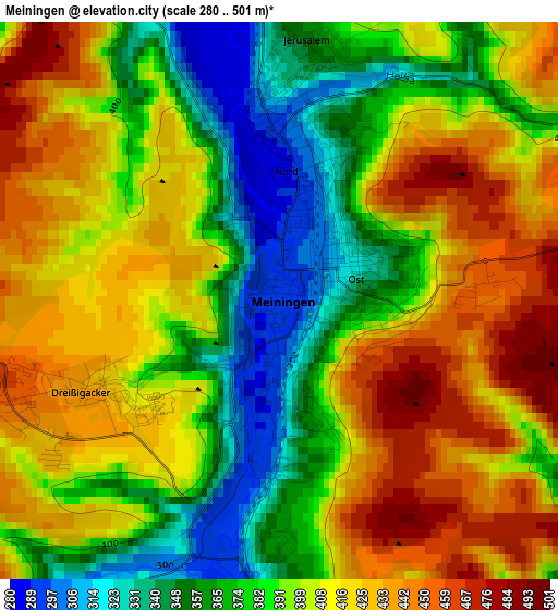
Below is the Elevation map of Meiningen, which displays elevation range with different colors. Scale of the first map is from 280 to 501 m (919 to 1644 ft) with average elevation of 397.9 meters (=1305 ft) [note 1]
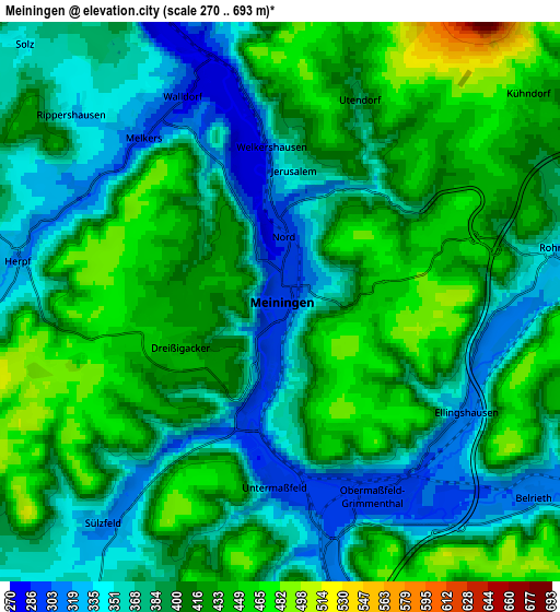
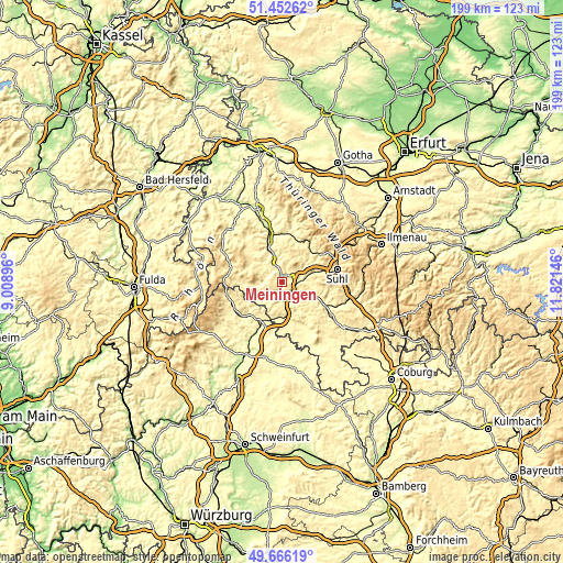
These maps also provides idea of topography and contour of this city, they are displayed at different zoom levels. More info about maps, scale and edge coordinates you can find below images.
| \ | Map #1 | Map #2 | Topo.Map |
| Scale [m] | 280..501 m | 270..693 m | × |
| Scale [ft] | 919..1644 ft | 886..2274 ft | × |
| Average | 397.9 m = 1305 ft | 398.8 m = 1308 ft | × |
| Width | 6.21 km = 3.9 mi | 12.41 km = 7.7 mi | 198.6 km = 123.4 mi |
| Height | 6.21 km = 3.9 mi | 12.41 km = 7.7 mi | 198.6 km = 123.4 mi |
| ↑Max Latitude | 50.595774° | 50.623662° | 51.45262° |
| Latitude at center | 50.56787° | 50.56787° | 50.56787° |
| ↓Min Latitude | 50.539949° | 50.512012° | 49.66619° |
| ← Min Longitude | 10.371265° | 10.327319° | 9.00896° |
| Longitude center | 10.41521° | 10.41521° | 10.41521° |
| →Max Longitude | 10.459155° | 10.503101° | 11.82146° |
Nearby cities:
Cities around Meiningen sort by population:
• Wasungen elevation 273 m
10.9 km,  342°
342°
• Themar 330 m
15.8 km,  116°
116°
• Schwallungen 274 m
14.5 km, 343°
• Walldorf 275 m
5.9 km, 337°
• Viernau 393 m
14.5 km,  43°
43°
• Jüchsen 347 m
11.5 km,  147°
147°
• Untermaßfeld 293 m
3.8 km,  178°
178°
• Obermaßfeld-Grimmenthal 300 m
4.7 km,  158°
158°
• Stockheim 299 m
15.7 km,  219°
219°
• Kühndorf 444 m
6.9 km,  49°
49°
• Rohr 341 m
5.9 km,  80°
80°
• Breitenbach 366 m
14.5 km,  21°
21°
Multilingual:
 En español:
Meiningen elevación 292 m.
 En France:
Meiningen élévation 292 m.
 Auf Deutsch:
Meiningen höhe über dem Meeresspiegel ist 292 m.

Sources and notes:
- [note 1] Map square and city borders are not equal. Map elevation data is calculated only from area inside that square.
- [src 1] Elevation data from geonames database provided with same terms of usage.
- [src 2] The elevation map of Meiningen is generated using elevation data from NASA's 3 arcsec (90m) resolution SRTM data.
- [src 3] Base (background) map © OpenStreetMap contributors tiles are generated by Geofabrik and OpenTopoMap.
Copyright & License:
This Meiningen Elevation Map is licensed under CC BY-SA. You may reuse any part from this page, if you give a proper credit by linking to this URL:
 More info on terms of use page.