Werther elevation
Werther (North Rhine-Westphalia, Regierungsbezirk Detmold), Germany elevation is 129 meters and Werther elevation in feet is 423 ft above sea level [src 1]. Werther is a populated place (feature code) with elevation that is 129 meters (423 ft) smaller than average city elevation in Germany.
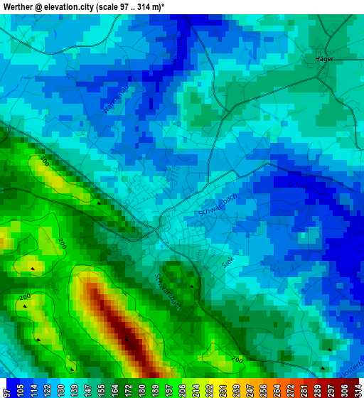
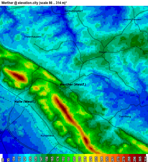
Below is the Elevation map of Werther, which displays elevation range with different colors. Scale of the first map is from 97 to 314 m (318 to 1030 ft) with average elevation of 148.5 meters (=487 ft) [note 1]
These maps also provides idea of topography and contour of this city, they are displayed at different zoom levels. More info about maps, scale and edge coordinates you can find below images.
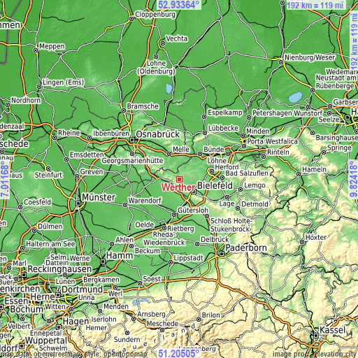
| \ | Map #1 | Map #2 | Topo.Map |
| Scale [m] | 97..314 m | 86..314 m | × |
| Scale [ft] | 318..1030 ft | 282..1030 ft | × |
| Average | 148.5 m = 487 ft | 137.5 m = 451 ft | × |
| Width | 6.01 km = 3.7 mi | 12.01 km = 7.5 mi | 192.2 km = 119.4 mi |
| Height | 6.01 km = 3.7 mi | 12.01 km = 7.5 mi | 192.2 km = 119.4 mi |
| ↑Max Latitude | 52.10471° | 52.131694° | 52.93364° |
| Latitude at center | 52.07771° | 52.07771° | 52.07771° |
| ↓Min Latitude | 52.050693° | 52.02366° | 51.20505° |
| ← Min Longitude | 8.373985° | 8.330039° | 7.01168° |
| Longitude center | 8.41793° | 8.41793° | 8.41793° |
| →Max Longitude | 8.461875° | 8.505821° | 9.82418° |
Nearby cities:
Cities around Werther sort by population:
• Bielefeld elevation 111 m
9.3 km,  122°
122°
• Melle 82 m
14.8 km,  338°
338°
• Bünde 74 m
17.7 km,  40°
40°
• Halle 129 m
4.4 km,  243°
243°
• Hiddenhausen 83 m
16.8 km,  53°
53°
• Steinhagen 96 m
8.7 km,  188°
188°
• Enger 98 m
11.8 km, 53°
• Spenge 90 m
8.3 km,  33°
33°
• Dissen 107 m
15.5 km,  285°
285°
• Borgholzhausen 133 m
8.4 km, 289°
• Bad Rothenfelde 100 m
17.7 km,  284°
284°
• Neuenkirchen 121 m
7 km, 343°
Multilingual:
 En español:
Werther elevación 129 m.
 En France:
Werther élévation 129 m.


Sources and notes:
- [note 1] Map square and city borders are not equal. Map elevation data is calculated only from area inside that square.
- [src 1] Elevation data from geonames database provided with same terms of usage.
- [src 2] The elevation map of Werther is generated using elevation data from NASA's 3 arcsec (90m) resolution SRTM data.
- [src 3] Base (background) map © OpenStreetMap contributors tiles are generated by Geofabrik and OpenTopoMap.
Copyright & License:
This Werther Elevation Map is licensed under CC BY-SA. You may reuse any part from this page, if you give a proper credit by linking to this URL:
 More info on terms of use page.