Borgholzhausen elevation
Borgholzhausen (North Rhine-Westphalia, Regierungsbezirk Detmold), Germany elevation is 133 meters and Borgholzhausen elevation in feet is 436 ft above sea level [src 1]. Borgholzhausen is a populated place (feature code) with elevation that is 125 meters (410 ft) smaller than average city elevation in Germany.
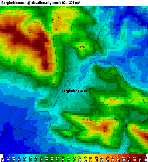
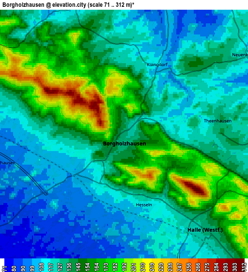
Below is the Elevation map of Borgholzhausen, which displays elevation range with different colors. Scale of the first map is from 92 to 301 m (302 to 988 ft) with average elevation of 159.8 meters (=524 ft) [note 1]
These maps also provides idea of topography and contour of this city, they are displayed at different zoom levels. More info about maps, scale and edge coordinates you can find below images.
| \ | Map #1 | Map #2 | Topo.Map |
| Scale [m] | 92..301 m | 71..312 m | × |
| Scale [ft] | 302..988 ft | 233..1024 ft | × |
| Average | 159.8 m = 524 ft | 135.7 m = 445 ft | × |
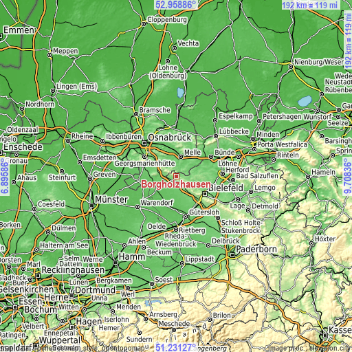
| Width | 6 km = 3.7 mi | 12.01 km = 7.5 mi | 192.1 km = 119.4 mi |
| Height | 6 km = 3.7 mi | 12.01 km = 7.5 mi | 192.1 km = 119.4 mi |
| ↑Max Latitude | 52.130415° | 52.157383° | 52.95886° |
| Latitude at center | 52.10343° | 52.10343° | 52.10343° |
| ↓Min Latitude | 52.076429° | 52.049412° | 51.23127° |
| ← Min Longitude | 8.258165° | 8.214219° | 6.89586° |
| Longitude center | 8.30211° | 8.30211° | 8.30211° |
| →Max Longitude | 8.346055° | 8.390001° | 9.70836° |
Nearby cities:
Cities around Borgholzhausen sort by population:
• Melle elevation 82 m
11.2 km,  12°
12°
• Harsewinkel 65 m
16.5 km,  197°
197°
• Halle 129 m
6.3 km,  140°
140°
• Versmold 70 m
12.4 km,  235°
235°
• Steinhagen 96 m
13.3 km,  149°
149°
• Spenge 90 m
13.1 km,  71°
71°
• Werther 129 m
8.4 km,  109°
109°
• Hilter 124 m
11.2 km,  288°
288°
• Dissen 107 m
7.1 km,  281°
281°
• Bad Laer 82 m
14.9 km,  268°
268°
• Bad Rothenfelde 100 m
9.4 km, 279°
• Neuenkirchen 121 m
7 km,  57°
57°
Multilingual:
 En español:
Borgholzhausen elevación 133 m.
 En France:
Borgholzhausen élévation 133 m.
 Auf Deutsch:
Borgholzhausen höhe über dem Meeresspiegel ist 133 m.

Sources and notes:
- [note 1] Map square and city borders are not equal. Map elevation data is calculated only from area inside that square.
- [src 1] Elevation data from geonames database provided with same terms of usage.
- [src 2] The elevation map of Borgholzhausen is generated using elevation data from NASA's 3 arcsec (90m) resolution SRTM data.
- [src 3] Base (background) map © OpenStreetMap contributors tiles are generated by Geofabrik and OpenTopoMap.
Copyright & License:
This Borgholzhausen Elevation Map is licensed under CC BY-SA. You may reuse any part from this page, if you give a proper credit by linking to this URL:
 More info on terms of use page.