Wippra elevation
Wippra (Saxony-Anhalt), Germany elevation is 248 meters and Wippra elevation in feet is 814 ft above sea level [src 1]. Wippra is a populated place (feature code) with elevation that is 10 meters (33 ft) smaller than average city elevation in Germany.
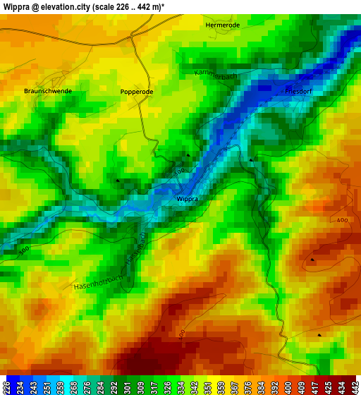
Below is the Elevation map of Wippra, which displays elevation range with different colors. Scale of the first map is from 226 to 442 m (741 to 1450 ft) with average elevation of 342.5 meters (=1124 ft) [note 1]
These maps also provides idea of topography and contour of this city, they are displayed at different zoom levels. More info about maps, scale and edge coordinates you can find below images.
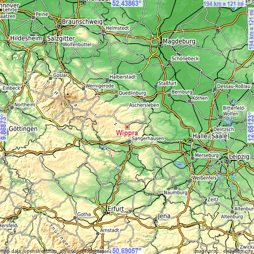
| \ | Map #1 | Topo.Map |
| Scale [m] | 226..442 m | × |
| Scale [ft] | 741..1450 ft | × |
| Average | 342.5 m = 1124 ft | × |
| Width | 6.07 km = 3.8 mi | 194.4 km = 120.8 mi |
| Height | 6.07 km = 3.8 mi | 194.3 km = 120.7 mi |
| ↑Max Latitude | 51.600305° | 52.43863° |
| Latitude at center | 51.573° | 51.573° |
| ↓Min Latitude | 51.545679° | 50.69057° |
| ← Min Longitude | 11.231035° | 9.86873° |
| Longitude center | 11.27498° | 11.27498° |
| →Max Longitude | 11.318925° | 12.68123° |
Nearby cities:
Cities around Wippra sort by population:
• Sangerhausen elevation 154 m
11.3 km,  172°
172°
• Harzgerode 394 m
11.9 km,  310°
310°
• Mansfeld 207 m
12.4 km,  80°
80°
• Klostermansfeld 246 m
15.6 km,  85°
85°
• Benndorf 238 m
15.1 km, 91°
• Wallhausen 144 m
13.3 km,  200°
200°
• Großörner 163 m
15.6 km,  72°
72°
• Ahlsdorf 223 m
13.6 km,  103°
103°
• Hergisdorf 189 m
15.1 km,  107°
107°
• Oberröblingen 130 m
15.3 km, 171°
• Riestedt 177 m
10.5 km,  145°
145°
• Blankenheim 297 m
12.9 km,  124°
124°
Multilingual:
 En español:
Wippra elevación 248 m.
 En France:
Wippra élévation 248 m.


Sources and notes:
- [note 1] Map square and city borders are not equal. Map elevation data is calculated only from area inside that square.
- [src 1] Elevation data from geonames database provided with same terms of usage.
- [src 2] The elevation map of Wippra is generated using elevation data from NASA's 3 arcsec (90m) resolution SRTM data.
- [src 3] Base (background) map © OpenStreetMap contributors tiles are generated by Geofabrik and OpenTopoMap.
Copyright & License:
This Wippra Elevation Map is licensed under CC BY-SA. You may reuse any part from this page, if you give a proper credit by linking to this URL:
 More info on terms of use page.