Ahlsdorf elevation
Ahlsdorf (Saxony-Anhalt), Germany elevation is 223 meters and Ahlsdorf elevation in feet is 732 ft above sea level [src 1]. Ahlsdorf is a seat of a fourth-order administrative division (feature code) with elevation that is 35 meters (115 ft) smaller than average city elevation in Germany.
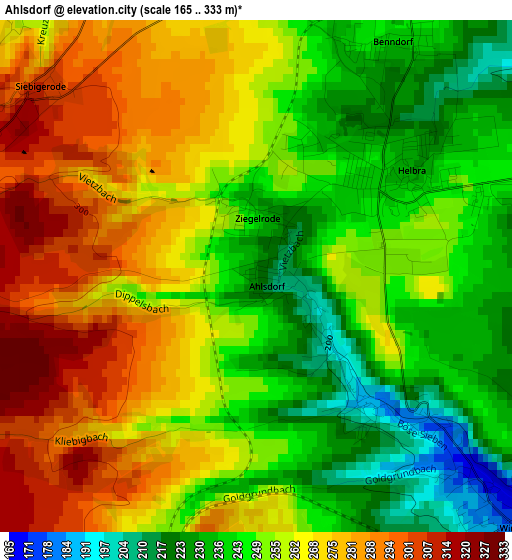
Below is the Elevation map of Ahlsdorf, which displays elevation range with different colors. Scale of the first map is from 165 to 333 m (541 to 1093 ft) with average elevation of 257.6 meters (=845 ft) [note 1]
These maps also provides idea of topography and contour of this city, they are displayed at different zoom levels. More info about maps, scale and edge coordinates you can find below images.
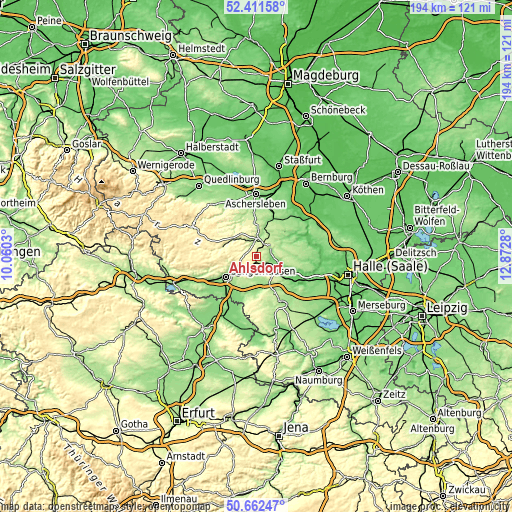
| \ | Map #1 | Topo.Map |
| Scale [m] | 165..333 m | × |
| Scale [ft] | 541..1093 ft | × |
| Average | 257.6 m = 845 ft | × |
| Width | 6.08 km = 3.8 mi | 194.5 km = 120.9 mi |
| Height | 6.08 km = 3.8 mi | 194.5 km = 120.9 mi |
| ↑Max Latitude | 51.572751° | 52.41158° |
| Latitude at center | 51.54543° | 51.54543° |
| ↓Min Latitude | 51.518092° | 50.66247° |
| ← Min Longitude | 11.422605° | 10.0603° |
| Longitude center | 11.46655° | 11.46655° |
| →Max Longitude | 11.510495° | 12.8728° |
Nearby cities:
Cities around Ahlsdorf sort by population:
• Eisleben Lutherstadt elevation 126 m
6 km,  109°
109°
• Helbra 251 m
2.4 km,  77°
77°
• Mansfeld 207 m
5.3 km,  349°
349°
• Klostermansfeld 246 m
4.8 km,  28°
28°
• Benndorf 238 m
3.3 km, 33°
• Großörner 163 m
7.9 km,  11°
11°
• Hergisdorf 189 m
1.8 km,  139°
139°
• Siersleben 218 m
8.4 km,  39°
39°
• Blankenheim 297 m
5 km,  211°
211°
• Wimmelburg 172 m
3.9 km,  134°
134°
• Volkstedt 152 m
6.5 km,  72°
72°
• Wolferode 207 m
5.4 km, 143°
Multilingual:
 En español:
Ahlsdorf elevación 223 m.
 En France:
Ahlsdorf élévation 223 m.
 Auf Deutsch:
Ahlsdorf höhe über dem Meeresspiegel ist 223 m.

Sources and notes:
- [note 1] Map square and city borders are not equal. Map elevation data is calculated only from area inside that square.
- [src 1] Elevation data from geonames database provided with same terms of usage.
- [src 2] The elevation map of Ahlsdorf is generated using elevation data from NASA's 3 arcsec (90m) resolution SRTM data.
- [src 3] Base (background) map © OpenStreetMap contributors tiles are generated by Geofabrik and OpenTopoMap.
Copyright & License:
This Ahlsdorf Elevation Map is licensed under CC BY-SA. You may reuse any part from this page, if you give a proper credit by linking to this URL:
 More info on terms of use page.