Wrestedt elevation
Wrestedt (Lower Saxony), Germany elevation is 48 meters and Wrestedt elevation in feet is 157 ft above sea level [src 1]. Wrestedt is a populated place (feature code) with elevation that is 210 meters (689 ft) smaller than average city elevation in Germany.
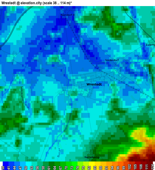
Below is the Elevation map of Wrestedt, which displays elevation range with different colors. Scale of the first map is from 38 to 114 m (125 to 374 ft) with average elevation of 52.6 meters (=173 ft) [note 1]
These maps also provides idea of topography and contour of this city, they are displayed at different zoom levels. More info about maps, scale and edge coordinates you can find below images.
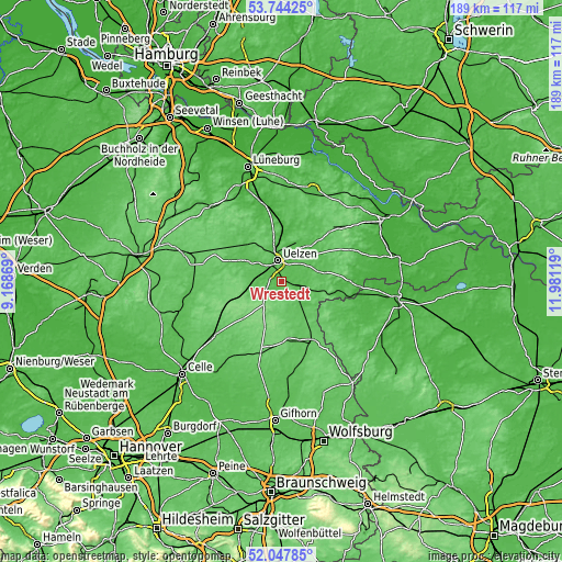
| \ | Map #1 | Topo.Map |
| Scale [m] | 38..114 m | × |
| Scale [ft] | 125..374 ft | × |
| Average | 52.6 m = 173 ft | × |
| Width | 5.89 km = 3.7 mi | 188.6 km = 117.2 mi |
| Height | 5.89 km = 3.7 mi | 188.6 km = 117.2 mi |
| ↑Max Latitude | 52.930847° | 53.74425° |
| Latitude at center | 52.90435° | 52.90435° |
| ↓Min Latitude | 52.877836° | 52.04785° |
| ← Min Longitude | 10.530995° | 9.16869° |
| Longitude center | 10.57494° | 10.57494° |
| →Max Longitude | 10.618885° | 11.98119° |
Nearby cities:
Cities around Wrestedt sort by population:
• Uelzen elevation 42 m
6.9 km,  352°
352°
• Ebstorf 71 m
17.3 km,  322°
322°
• Suderburg 58 m
8.3 km,  263°
263°
• Wieren 56 m
6 km,  110°
110°
• Suhlendorf 62 m
13.3 km,  75°
75°
• Rosche 61 m
15 km,  52°
52°
• Gerdau 49 m
12.7 km,  303°
303°
• Stadensen 57 m
3.4 km,  201°
201°
• Sprakensehl 112 m
16.3 km, 200°
• Lüder 68 m
12.3 km,  150°
150°
• Soltendieck 65 m
13 km, 105°
• Eimke 66 m
18.8 km,  291°
291°
Multilingual:
 En español:
Wrestedt elevación 48 m.
 En France:
Wrestedt élévation 48 m.


Sources and notes:
- [note 1] Map square and city borders are not equal. Map elevation data is calculated only from area inside that square.
- [src 1] Elevation data from geonames database provided with same terms of usage.
- [src 2] The elevation map of Wrestedt is generated using elevation data from NASA's 3 arcsec (90m) resolution SRTM data.
- [src 3] Base (background) map © OpenStreetMap contributors tiles are generated by Geofabrik and OpenTopoMap.
Copyright & License:
This Wrestedt Elevation Map is licensed under CC BY-SA. You may reuse any part from this page, if you give a proper credit by linking to this URL:
 More info on terms of use page.