Zeitz elevation
Zeitz (Saxony-Anhalt), Germany elevation is 191 meters and Zeitz elevation in feet is 627 ft above sea level [src 1]. Zeitz is a populated place (feature code) with elevation that is 67 meters (220 ft) smaller than average city elevation in Germany.
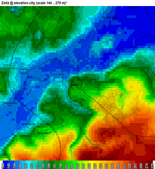
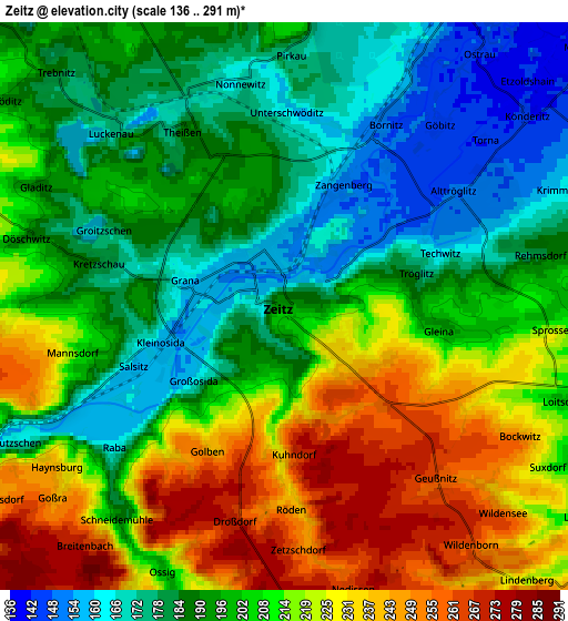
Below is the Elevation map of Zeitz, which displays elevation range with different colors. Scale of the first map is from 144 to 279 m (472 to 915 ft) with average elevation of 192 meters (=630 ft) [note 1]
These maps also provides idea of topography and contour of this city, they are displayed at different zoom levels. More info about maps, scale and edge coordinates you can find below images.
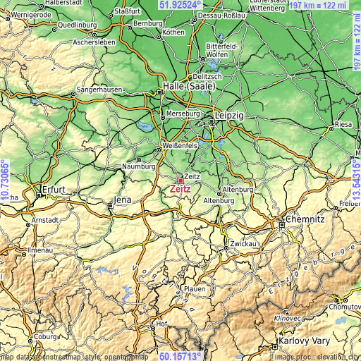
| \ | Map #1 | Map #2 | Topo.Map |
| Scale [m] | 144..279 m | 136..291 m | × |
| Scale [ft] | 472..915 ft | 446..955 ft | × |
| Average | 192 m = 630 ft | 203.3 m = 667 ft | × |
| Width | 6.14 km = 3.8 mi | 12.29 km = 7.6 mi | 196.6 km = 122.2 mi |
| Height | 6.14 km = 3.8 mi | 12.29 km = 7.6 mi | 196.6 km = 122.2 mi |
| ↑Max Latitude | 51.077238° | 51.104839° | 51.92524° |
| Latitude at center | 51.04962° | 51.04962° | 51.04962° |
| ↓Min Latitude | 51.021986° | 50.994335° | 50.15713° |
| ← Min Longitude | 12.092955° | 12.049009° | 10.73065° |
| Longitude center | 12.1369° | 12.1369° | 12.1369° |
| →Max Longitude | 12.180845° | 12.224791° | 13.54315° |
Nearby cities:
Cities around Zeitz sort by population:
• Hohenmölsen elevation 184 m
12.3 km,  347°
347°
• Meuselwitz 176 m
11.4 km,  93°
93°
• Teuchern 170 m
11.2 km,  315°
315°
• Theißen 173 m
4.7 km,  333°
333°
• Droyßig 231 m
7.8 km,  264°
264°
• Elstertrebnitz 132 m
13 km,  31°
31°
• Kayna 217 m
9.3 km,  131°
131°
• Pölzig 285 m
11.9 km,  158°
158°
• Kretzschau 194 m
4.9 km,  270°
270°
• Deuben 197 m
8 km, 326°
• Wetterzeube 159 m
10.1 km,  236°
236°
• Nessa 180 m
13.9 km, 320°
Multilingual:
 En español:
Zeitz elevación 191 m.
 En France:
Zeitz élévation 191 m.


Sources and notes:
- [note 1] Map square and city borders are not equal. Map elevation data is calculated only from area inside that square.
- [src 1] Elevation data from geonames database provided with same terms of usage.
- [src 2] The elevation map of Zeitz is generated using elevation data from NASA's 3 arcsec (90m) resolution SRTM data.
- [src 3] Base (background) map © OpenStreetMap contributors tiles are generated by Geofabrik and OpenTopoMap.
Copyright & License:
This Zeitz Elevation Map is licensed under CC BY-SA. You may reuse any part from this page, if you give a proper credit by linking to this URL:
 More info on terms of use page.