Meuselwitz elevation
Meuselwitz (Thuringia), Germany elevation is 176 meters and Meuselwitz elevation in feet is 577 ft above sea level [src 1]. Meuselwitz is a populated place (feature code) with elevation that is 82 meters (269 ft) smaller than average city elevation in Germany.
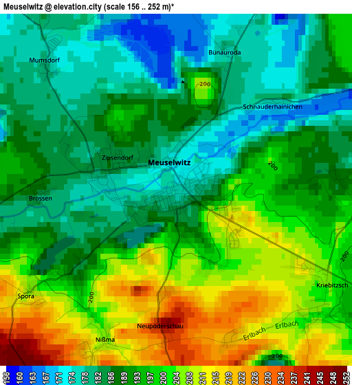
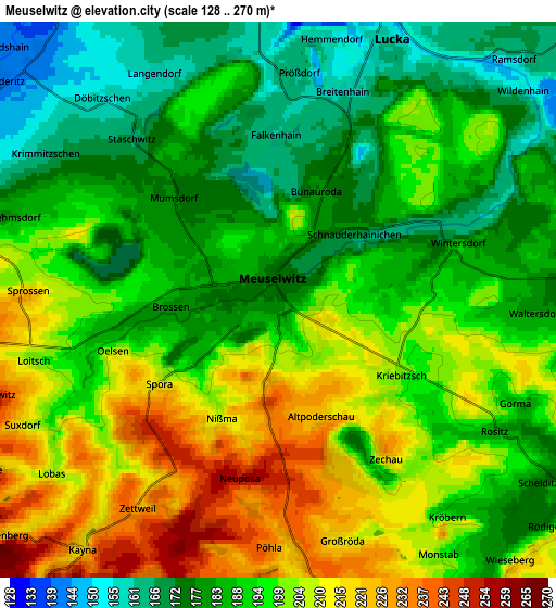
Below is the Elevation map of Meuselwitz, which displays elevation range with different colors. Scale of the first map is from 156 to 252 m (512 to 827 ft) with average elevation of 193.2 meters (=634 ft) [note 1]
These maps also provides idea of topography and contour of this city, they are displayed at different zoom levels. More info about maps, scale and edge coordinates you can find below images.
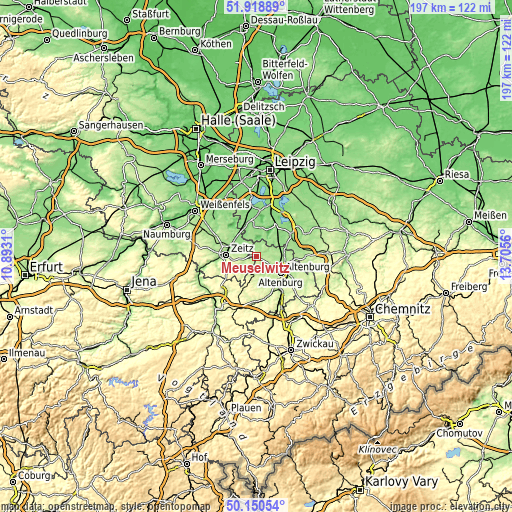
| \ | Map #1 | Map #2 | Topo.Map |
| Scale [m] | 156..252 m | 128..270 m | × |
| Scale [ft] | 512..827 ft | 420..886 ft | × |
| Average | 193.2 m = 634 ft | 193.9 m = 636 ft | × |
| Width | 6.14 km = 3.8 mi | 12.29 km = 7.6 mi | 196.6 km = 122.2 mi |
| Height | 6.14 km = 3.8 mi | 12.29 km = 7.6 mi | 196.6 km = 122.2 mi |
| ↑Max Latitude | 51.070772° | 51.098377° | 51.91889° |
| Latitude at center | 51.04315° | 51.04315° | 51.04315° |
| ↓Min Latitude | 51.015512° | 50.987857° | 50.15054° |
| ← Min Longitude | 12.255405° | 12.211459° | 10.8931° |
| Longitude center | 12.29935° | 12.29935° | 12.29935° |
| →Max Longitude | 12.343295° | 12.387241° | 13.7056° |
Nearby cities:
Cities around Meuselwitz sort by population:
• Altenburg elevation 193 m
11.4 km,  122°
122°
• Zeitz 191 m
11.4 km,  273°
273°
• Groitzsch 140 m
12.5 km,  354°
354°
• Lucka 153 m
6.5 km,  21°
21°
• Regis-Breitingen 146 m
11 km,  62°
62°
• Rositz 193 m
5.3 km, 122°
• Wintersdorf 186 m
4 km,  73°
73°
• Windischleuba 170 m
12.3 km,  104°
104°
• Deutzen 149 m
11.7 km,  48°
48°
• Kayna 217 m
7 km,  218°
218°
• Pölzig 285 m
12.5 km,  213°
213°
• Kriebitzsch 203 m
3.2 km,  132°
132°
Multilingual:
 En español:
Meuselwitz elevación 176 m.
 En France:
Meuselwitz élévation 176 m.
 Auf Deutsch:
Meuselwitz höhe über dem Meeresspiegel ist 176 m.

Sources and notes:
- [note 1] Map square and city borders are not equal. Map elevation data is calculated only from area inside that square.
- [src 1] Elevation data from geonames database provided with same terms of usage.
- [src 2] The elevation map of Meuselwitz is generated using elevation data from NASA's 3 arcsec (90m) resolution SRTM data.
- [src 3] Base (background) map © OpenStreetMap contributors tiles are generated by Geofabrik and OpenTopoMap.
Copyright & License:
This Meuselwitz Elevation Map is licensed under CC BY-SA. You may reuse any part from this page, if you give a proper credit by linking to this URL:
 More info on terms of use page.