Blatná elevation
Blatná (Jihočeský kraj, Okres Strakonice), Czech Republic elevation is 442 meters and Blatná elevation in feet is 1450 ft above sea level [src 1]. Blatná is a populated place (feature code) with elevation that is 97 meters (318 ft) bigger than average city elevation in Czech Republic.
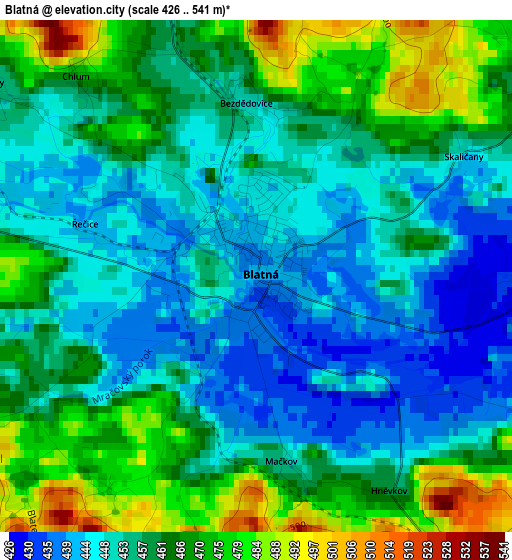
Below is the Elevation map of Blatná, which displays elevation range with different colors. Scale of the first map is from 426 to 541 m (1398 to 1775 ft) with average elevation of 458.5 meters (=1504 ft) [note 1]
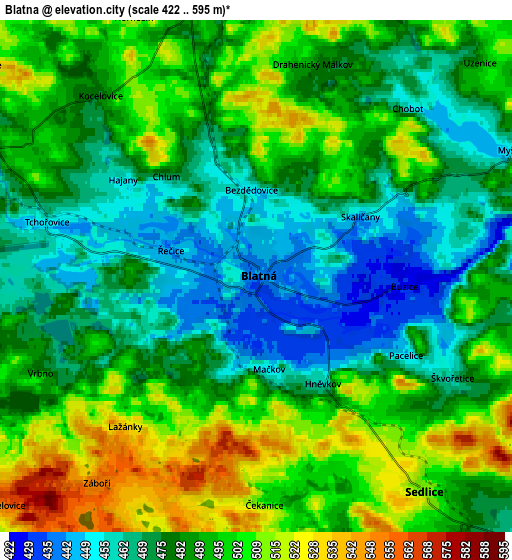
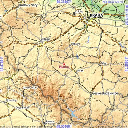
These maps also provides idea of topography and contour of this city, they are displayed at different zoom levels. More info about maps, scale and edge coordinates you can find below images.
| \ | Map #1 | Map #2 | Topo.Map |
| Scale [m] | 426..541 m | 422..595 m | × |
| Scale [ft] | 1398..1775 ft | 1385..1952 ft | × |
| Average | 458.5 m = 1504 ft | 486.3 m = 1595 ft | × |
| Width | 6.36 km = 4 mi | 12.71 km = 7.9 mi | 203.4 km = 126.4 mi |
| Height | 6.36 km = 4 mi | 12.71 km = 7.9 mi | 203.4 km = 126.4 mi |
| ↑Max Latitude | 49.453466° | 49.482025° | 50.33107° |
| Latitude at center | 49.42489° | 49.42489° | 49.42489° |
| ↓Min Latitude | 49.396298° | 49.367689° | 48.50166° |
| ← Min Longitude | 13.837815° | 13.793869° | 12.47551° |
| Longitude center | 13.88176° | 13.88176° | 13.88176° |
| →Max Longitude | 13.925705° | 13.969651° | 15.28801° |
Nearby cities:
Cities around Blatná sort by population:
• Strakonice elevation 403 m
18.2 km,  175°
175°
• Horažďovice 433 m
17.5 km,  228°
228°
• Rožmitál pod Třemšínem 524 m
19.7 km,  356°
356°
• Nepomuk 451 m
22.7 km,  287°
287°
• Březnice 468 m
15.6 km,  18°
18°
• Mirovice 441 m
15 km,  47°
47°
• Kasejovice 541 m
11 km, 292°
• Katovice 409 m
17.2 km,  192°
192°
• Sedlice 512 m
6.7 km,  142°
142°
• Radomyšl 457 m
12.6 km,  163°
163°
• Mirotice 420 m
11.2 km,  87°
87°
• Čimelice 425 m
14.3 km,  71°
71°
Multilingual:
 En español:
Blatná elevación 442 m.
 En France:
Blatná élévation 442 m.


Sources and notes:
- [note 1] Map square and city borders are not equal. Map elevation data is calculated only from area inside that square.
- [src 1] Elevation data from geonames database provided with same terms of usage.
- [src 2] The elevation map of Blatná is generated using elevation data from NASA's 3 arcsec (90m) resolution SRTM data.
- [src 3] Base (background) map © OpenStreetMap contributors tiles are generated by Geofabrik and OpenTopoMap.
Copyright & License:
This Blatná Elevation Map is licensed under CC BY-SA. You may reuse any part from this page, if you give a proper credit by linking to this URL:
 More info on terms of use page.