Rožmitál pod Třemšínem elevation
Rožmitál pod Třemšínem (Central Bohemia, Okres Příbram), Czech Republic elevation is 524 meters and Rožmitál pod Třemšínem elevation in feet is 1719 ft above sea level [src 1]. Rožmitál pod Třemšínem is a populated place (feature code) with elevation that is 179 meters (587 ft) bigger than average city elevation in Czech Republic.
Below is the Elevation map of Rožmitál pod Třemšínem, which displays elevation range with different colors. Scale of the first map is from 493 to 757 m (1617 to 2484 ft) with average elevation of 563.8 meters (=1850 ft) [note 1]
These maps also provides idea of topography and contour of this city, they are displayed at different zoom levels. More info about maps, scale and edge coordinates you can find below images.
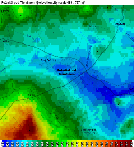
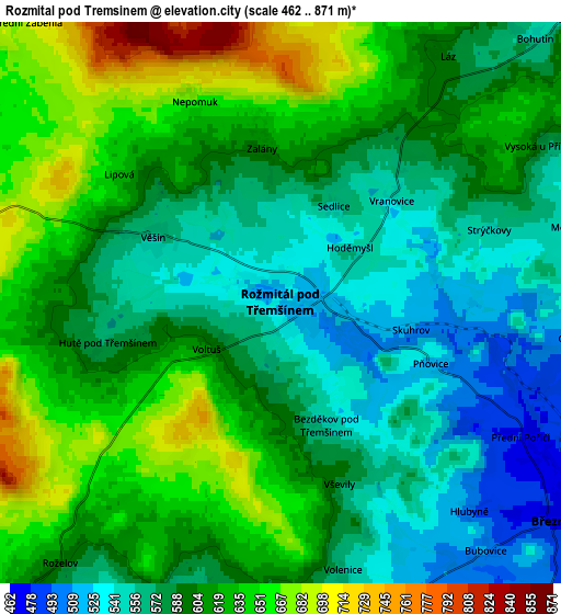
| \ | Map #1 | Map #2 | Topo.Map |
| Scale [m] | 493..757 m | 462..871 m | × |
| Scale [ft] | 1617..2484 ft | 1516..2858 ft | × |
| Average | 563.8 m = 1850 ft | 600.2 m = 1969 ft | × |
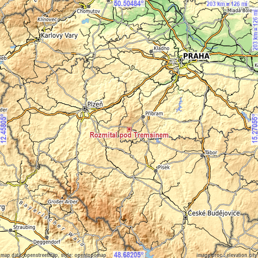
| Width | 6.33 km = 3.9 mi | 12.67 km = 7.9 mi | 202.7 km = 126 mi |
| Height | 6.33 km = 3.9 mi | 12.67 km = 7.9 mi | 202.7 km = 126 mi |
| ↑Max Latitude | 49.630432° | 49.658888° | 50.50484° |
| Latitude at center | 49.60196° | 49.60196° | 49.60196° |
| ↓Min Latitude | 49.573471° | 49.544965° | 48.68205° |
| ← Min Longitude | 13.820355° | 13.776409° | 12.45805° |
| Longitude center | 13.8643° | 13.8643° | 13.8643° |
| →Max Longitude | 13.908245° | 13.952191° | 15.27055° |
Nearby cities:
Cities around Rožmitál pod Třemšínem sort by population:
• Příbram elevation 510 m
14.4 km,  47°
47°
• Březnice 468 m
7.9 km,  128°
128°
• Spálené Poříčí 415 m
18.7 km,  274°
274°
• Strašice 508 m
16.7 km,  332°
332°
• Mirošov 455 m
17.7 km,  302°
302°
• Milín 550 m
13.5 km,  75°
75°
• Mirovice 441 m
15.7 km, 127°
• Bohutín 554 m
8.3 km,  43°
43°
• Zaječov 456 m
19.2 km,  354°
354°
• Kasejovice 541 m
17.9 km,  209°
209°
• Obecnice 523 m
14 km,  25°
25°
• Dobřív 419 m
18 km,  314°
314°
Multilingual:
 En español:
Rožmitál pod Třemšínem elevación 524 m.
 En France:
Rožmitál pod Třemšínem élévation 524 m.
 Auf Deutsch:
Rožmitál pod Třemšínem höhe über dem Meeresspiegel ist 524 m.
 На русском:
Rožmitál pod Třemšínem высота над уровнем моря 524 м
Sources and notes:
- [note 1] Map square and city borders are not equal. Map elevation data is calculated only from area inside that square.
- [src 1] Elevation data from geonames database provided with same terms of usage.
- [src 2] The elevation map of Rožmitál pod Třemšínem is generated using elevation data from NASA's 3 arcsec (90m) resolution SRTM data.
- [src 3] Base (background) map © OpenStreetMap contributors tiles are generated by Geofabrik and OpenTopoMap.
Copyright & License:
This Rožmitál pod Třemšínem Elevation Map is licensed under CC BY-SA. You may reuse any part from this page, if you give a proper credit by linking to this URL:
 More info on terms of use page.