Křižanov elevation
Křižanov (Vysočina, Okres Žďár nad Sázavou), Czech Republic elevation is 525 meters and Křižanov elevation in feet is 1722 ft above sea level [src 1]. Křižanov is a populated place (feature code) with elevation that is 180 meters (591 ft) bigger than average city elevation in Czech Republic.
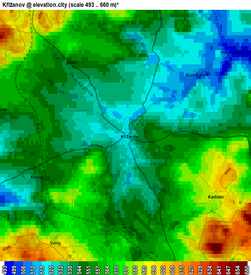
Below is the Elevation map of Křižanov, which displays elevation range with different colors. Scale of the first map is from 493 to 660 m (1617 to 2165 ft) with average elevation of 553.4 meters (=1816 ft) [note 1]
These maps also provides idea of topography and contour of this city, they are displayed at different zoom levels. More info about maps, scale and edge coordinates you can find below images.
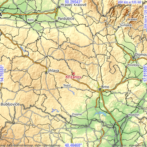
| \ | Map #1 | Topo.Map |
| Scale [m] | 493..660 m | × |
| Scale [ft] | 1617..2165 ft | × |
| Average | 553.4 m = 1816 ft | × |
| Width | 6.36 km = 4 mi | 203.6 km = 126.5 mi |
| Height | 6.36 km = 4 mi | 203.5 km = 126.4 mi |
| ↑Max Latitude | 49.417177° | 50.29543° |
| Latitude at center | 49.38858° | 49.38858° |
| ↓Min Latitude | 49.359967° | 48.46468° |
| ← Min Longitude | 16.065655° | 14.70335° |
| Longitude center | 16.1096° | 16.1096° |
| →Max Longitude | 16.153545° | 17.51585° |
Nearby cities:
Cities around Křižanov sort by population:
• Velké Meziříčí elevation 426 m
8 km,  242°
242°
• Nové Město na Moravě 602 m
19.4 km,  352°
352°
• Bystřice nad Pernštejnem 534 m
18.5 km,  36°
36°
• Náměšť nad Oslavou 429 m
20.5 km,  170°
170°
• Velká Bíteš 477 m
14 km,  142°
142°
• Měřín 490 m
16.3 km,  271°
271°
• Předklášteří 261 m
21.6 km,  100°
100°
• Nedvědice 328 m
17.9 km,  64°
64°
• Nové Veselí 559 m
20.6 km,  315°
315°
• Budišov 484 m
15.1 km,  210°
210°
• Dolní Loućky 280 m
18.3 km, 99°
• Bohdalov 577 m
19.7 km,  300°
300°
Multilingual:
 En español:
Křižanov elevación 525 m.
 En France:
Křižanov élévation 525 m.
 Auf Deutsch:
Křižanov höhe über dem Meeresspiegel ist 525 m.

Sources and notes:
- [note 1] Map square and city borders are not equal. Map elevation data is calculated only from area inside that square.
- [src 1] Elevation data from geonames database provided with same terms of usage.
- [src 2] The elevation map of Křižanov is generated using elevation data from NASA's 3 arcsec (90m) resolution SRTM data.
- [src 3] Base (background) map © OpenStreetMap contributors tiles are generated by Geofabrik and OpenTopoMap.
Copyright & License:
This Křižanov Elevation Map is licensed under CC BY-SA. You may reuse any part from this page, if you give a proper credit by linking to this URL:
 More info on terms of use page.