Nové Veselí elevation
Nové Veselí (Vysočina, Okres Žďár nad Sázavou), Czech Republic elevation is 559 meters and Nové Veselí elevation in feet is 1834 ft above sea level [src 1]. Nové Veselí is a populated place (feature code) with elevation that is 214 meters (702 ft) bigger than average city elevation in Czech Republic.
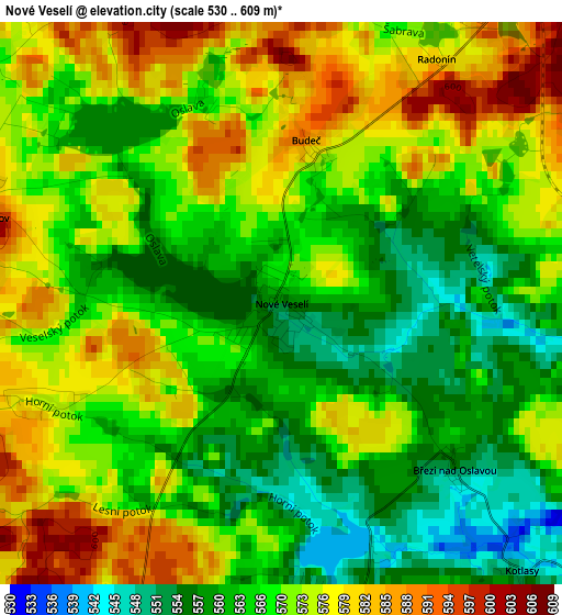
Below is the Elevation map of Nové Veselí, which displays elevation range with different colors. Scale of the first map is from 530 to 609 m (1739 to 1998 ft) with average elevation of 569.2 meters (=1867 ft) [note 1]
These maps also provides idea of topography and contour of this city, they are displayed at different zoom levels. More info about maps, scale and edge coordinates you can find below images.
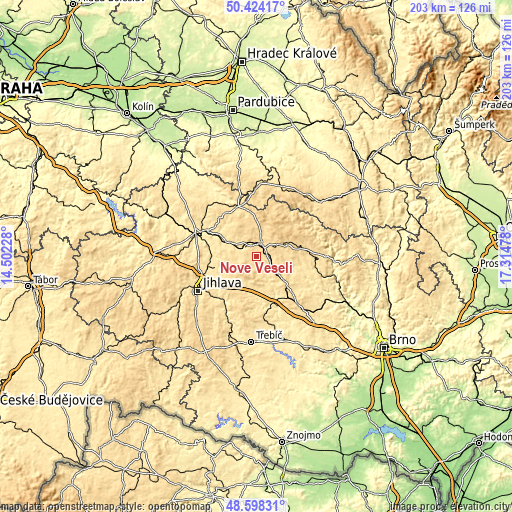
| \ | Map #1 | Topo.Map |
| Scale [m] | 530..609 m | × |
| Scale [ft] | 1739..1998 ft | × |
| Average | 569.2 m = 1867 ft | × |
| Width | 6.34 km = 3.9 mi | 203 km = 126.1 mi |
| Height | 6.34 km = 3.9 mi | 203 km = 126.1 mi |
| ↑Max Latitude | 49.54828° | 50.42417° |
| Latitude at center | 49.51976° | 49.51976° |
| ↓Min Latitude | 49.491223° | 48.59831° |
| ← Min Longitude | 15.864585° | 14.50228° |
| Longitude center | 15.90853° | 15.90853° |
| →Max Longitude | 15.952475° | 17.31478° |
Nearby cities:
Cities around Nové Veselí sort by population:
• Žďár nad Sázavou elevation 580 m
5.3 km,  24°
24°
• Žďár nad Sázavou Druhy 578 m
7.7 km,  12°
12°
• Velké Meziříčí 426 m
19.8 km,  157°
157°
• Nové Město na Moravě 602 m
12.8 km,  68°
68°
• Polná 490 m
14.2 km,  255°
255°
• Přibyslav 487 m
13.8 km,  297°
297°
• Dobronín 481 m
19.2 km, 256°
• Měřín 490 m
14.2 km,  187°
187°
• Kamenice 521 m
19.4 km,  208°
208°
• Křížová 572 m
19.2 km,  347°
347°
• Herálec 642 m
19.8 km, 18°
• Bohdalov 577 m
5.1 km, 207°
Multilingual:
 En español:
Nové Veselí elevación 559 m.
 En France:
Nové Veselí élévation 559 m.
 Auf Deutsch:
Nové Veselí höhe über dem Meeresspiegel ist 559 m.

Sources and notes:
- [note 1] Map square and city borders are not equal. Map elevation data is calculated only from area inside that square.
- [src 1] Elevation data from geonames database provided with same terms of usage.
- [src 2] The elevation map of Nové Veselí is generated using elevation data from NASA's 3 arcsec (90m) resolution SRTM data.
- [src 3] Base (background) map © OpenStreetMap contributors tiles are generated by Geofabrik and OpenTopoMap.
Copyright & License:
This Nové Veselí Elevation Map is licensed under CC BY-SA. You may reuse any part from this page, if you give a proper credit by linking to this URL:
 More info on terms of use page.