Nesovice elevation
Nesovice (South Moravian, Okres Vyškov), Czech Republic elevation is 239 meters and Nesovice elevation in feet is 784 ft above sea level [src 1]. Nesovice is a populated place (feature code) with elevation that is 106 meters (348 ft) smaller than average city elevation in Czech Republic.
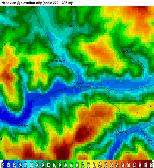
Below is the Elevation map of Nesovice, which displays elevation range with different colors. Scale of the first map is from 222 to 393 m (728 to 1289 ft) with average elevation of 291.6 meters (=957 ft) [note 1]
These maps also provides idea of topography and contour of this city, they are displayed at different zoom levels. More info about maps, scale and edge coordinates you can find below images.
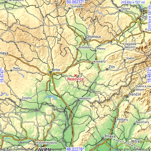
| \ | Map #1 | Topo.Map |
| Scale [m] | 222..393 m | × |
| Scale [ft] | 728..1289 ft | × |
| Average | 291.6 m = 957 ft | × |
| Width | 6.39 km = 4 mi | 204.5 km = 127.1 mi |
| Height | 6.39 km = 4 mi | 204.5 km = 127.1 mi |
| ↑Max Latitude | 49.179845° | 50.06237° |
| Latitude at center | 49.15111° | 49.15111° |
| ↓Min Latitude | 49.122359° | 48.22278° |
| ← Min Longitude | 17.037005° | 15.6747° |
| Longitude center | 17.08095° | 17.08095° |
| →Max Longitude | 17.124895° | 18.4872° |
Nearby cities:
Cities around Nesovice sort by population:
• Vyškov elevation 254 m
15.3 km,  337°
337°
• Kyjov 191 m
16 km,  169°
169°
• Bučovice 219 m
5.8 km,  267°
267°
• Slavkov u Brna 211 m
14.9 km, 270°
• Rousínov 235 m
15.5 km,  291°
291°
• Koryčany 284 m
7.8 km,  129°
129°
• Ivanovice na Hané 224 m
17.2 km,  3°
3°
• Ždánice 223 m
10.1 km,  202°
202°
• Drnovice 266 m
16.8 km,  325°
325°
• Letonice 260 m
9.3 km, 288°
• Dambořice 213 m
17.3 km,  223°
223°
• Žeravice 268 m
18.2 km,  141°
141°
Multilingual:
 En español:
Nesovice elevación 239 m.
 En France:
Nesovice élévation 239 m.
 Auf Deutsch:
Nesovice höhe über dem Meeresspiegel ist 239 m.

Sources and notes:
- [note 1] Map square and city borders are not equal. Map elevation data is calculated only from area inside that square.
- [src 1] Elevation data from geonames database provided with same terms of usage.
- [src 2] The elevation map of Nesovice is generated using elevation data from NASA's 3 arcsec (90m) resolution SRTM data.
- [src 3] Base (background) map © OpenStreetMap contributors tiles are generated by Geofabrik and OpenTopoMap.
Copyright & License:
This Nesovice Elevation Map is licensed under CC BY-SA. You may reuse any part from this page, if you give a proper credit by linking to this URL:
 More info on terms of use page.