Kyjov elevation
Kyjov (South Moravian, Okres Hodonín), Czech Republic elevation is 191 meters and Kyjov elevation in feet is 627 ft above sea level [src 1]. Kyjov is a populated place (feature code) with elevation that is 154 meters (505 ft) smaller than average city elevation in Czech Republic.
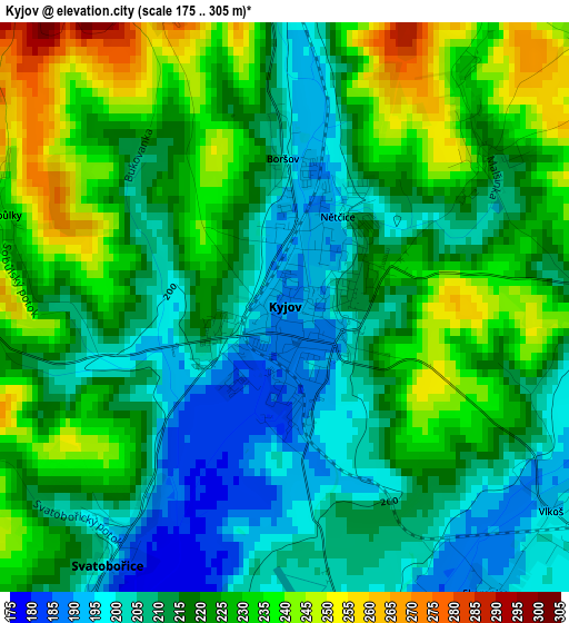
Below is the Elevation map of Kyjov, which displays elevation range with different colors. Scale of the first map is from 175 to 305 m (574 to 1001 ft) with average elevation of 218.6 meters (=717 ft) [note 1]
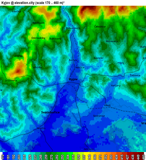
These maps also provides idea of topography and contour of this city, they are displayed at different zoom levels. More info about maps, scale and edge coordinates you can find below images.
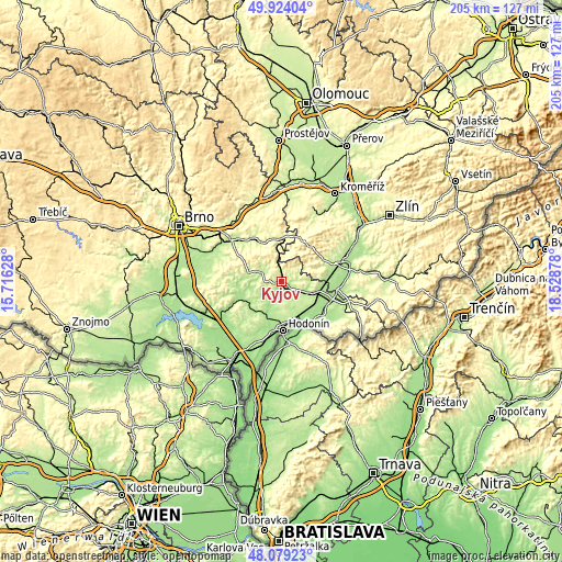
| \ | Map #1 | Map #2 | Topo.Map |
| Scale [m] | 175..305 m | 170..460 m | × |
| Scale [ft] | 574..1001 ft | 558..1509 ft | × |
| Average | 218.6 m = 717 ft | 235.2 m = 772 ft | × |
| Width | 6.41 km = 4 mi | 12.82 km = 8 mi | 205.1 km = 127.4 mi |
| Height | 6.41 km = 4 mi | 12.82 km = 8 mi | 205.1 km = 127.4 mi |
| ↑Max Latitude | 49.038996° | 49.067796° | 49.92404° |
| Latitude at center | 49.01018° | 49.01018° | 49.01018° |
| ↓Min Latitude | 48.981347° | 48.952497° | 48.07923° |
| ← Min Longitude | 17.078585° | 17.034639° | 15.71628° |
| Longitude center | 17.12253° | 17.12253° | 17.12253° |
| →Max Longitude | 17.166475° | 17.210421° | 18.52878° |
Nearby cities:
Cities around Kyjov sort by population:
• Dubňany elevation 191 m
10.6 km,  192°
192°
• Vracov 195 m
7.5 km,  121°
121°
• Bzenec 188 m
11.3 km,  111°
111°
• Ratíškovice 202 m
10.5 km,  162°
162°
• Koryčany 284 m
11.1 km,  15°
15°
• Ždánice 223 m
9.4 km,  312°
312°
• Hovorany 193 m
11.2 km,  236°
236°
• Šardice 183 m
8.6 km,  233°
233°
• Vacenovice 202 m
8.2 km,  152°
152°
• Milotice 183 m
6.3 km,  166°
166°
• Vlkoš 193 m
3.8 km,  127°
127°
• Žeravice 268 m
8.5 km,  80°
80°
Multilingual:
 En español:
Kyjov elevación 191 m.
 En France:
Kyjov élévation 191 m.


Sources and notes:
- [note 1] Map square and city borders are not equal. Map elevation data is calculated only from area inside that square.
- [src 1] Elevation data from geonames database provided with same terms of usage.
- [src 2] The elevation map of Kyjov is generated using elevation data from NASA's 3 arcsec (90m) resolution SRTM data.
- [src 3] Base (background) map © OpenStreetMap contributors tiles are generated by Geofabrik and OpenTopoMap.
Copyright & License:
This Kyjov Elevation Map is licensed under CC BY-SA. You may reuse any part from this page, if you give a proper credit by linking to this URL:
 More info on terms of use page.