Odry elevation
Odry (Moravskoslezský, Okres Nový Jičín), Czech Republic elevation is 305 meters and Odry elevation in feet is 1001 ft above sea level [src 1]. Odry is a populated place (feature code) with elevation that is 40 meters (131 ft) smaller than average city elevation in Czech Republic.
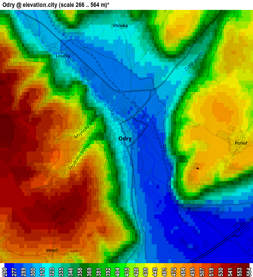
Below is the Elevation map of Odry, which displays elevation range with different colors. Scale of the first map is from 266 to 564 m (873 to 1850 ft) with average elevation of 398.6 meters (=1308 ft) [note 1]
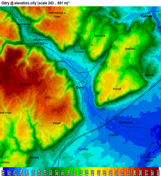
These maps also provides idea of topography and contour of this city, they are displayed at different zoom levels. More info about maps, scale and edge coordinates you can find below images.
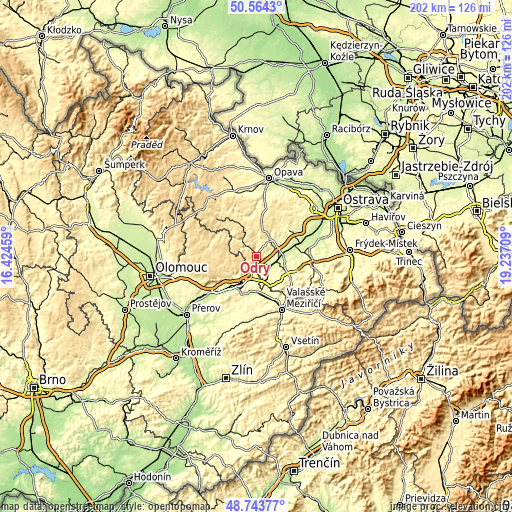
| \ | Map #1 | Map #2 | Topo.Map |
| Scale [m] | 266..564 m | 243..601 m | × |
| Scale [ft] | 873..1850 ft | 797..1972 ft | × |
| Average | 398.6 m = 1308 ft | 390.6 m = 1281 ft | × |
| Width | 6.33 km = 3.9 mi | 12.65 km = 7.9 mi | 202.4 km = 125.8 mi |
| Height | 6.33 km = 3.9 mi | 12.65 km = 7.9 mi | 202.4 km = 125.8 mi |
| ↑Max Latitude | 49.690987° | 49.719407° | 50.5643° |
| Latitude at center | 49.66255° | 49.66255° | 49.66255° |
| ↓Min Latitude | 49.634096° | 49.605626° | 48.74377° |
| ← Min Longitude | 17.786895° | 17.742949° | 16.42459° |
| Longitude center | 17.83084° | 17.83084° | 17.83084° |
| →Max Longitude | 17.874785° | 17.918731° | 19.23709° |
Nearby cities:
Cities around Odry sort by population:
• Nový Jičín elevation 287 m
15 km,  120°
120°
• Hranice 261 m
14.5 km,  208°
208°
• Vítkov 470 m
13.8 km,  334°
334°
• Fulnek 290 m
7.6 km,  43°
43°
• Vlčnov 342 m
12.9 km,  136°
136°
• Starý Jičín 366 m
13.4 km, 135°
• Jeseník nad Odrou 258 m
7.8 km, 136°
• Kunín 251 m
11.9 km,  105°
105°
• Hustopeče Nad Bečvou 273 m
14.9 km,  169°
169°
• Bělotín 294 m
8.1 km,  192°
192°
• Březová 518 m
14.6 km,  9°
9°
• Potštát 498 m
13.2 km,  257°
257°
Multilingual:
 En español:
Odry elevación 305 m.
 En France:
Odry élévation 305 m.


Sources and notes:
- [note 1] Map square and city borders are not equal. Map elevation data is calculated only from area inside that square.
- [src 1] Elevation data from geonames database provided with same terms of usage.
- [src 2] The elevation map of Odry is generated using elevation data from NASA's 3 arcsec (90m) resolution SRTM data.
- [src 3] Base (background) map © OpenStreetMap contributors tiles are generated by Geofabrik and OpenTopoMap.
Copyright & License:
This Odry Elevation Map is licensed under CC BY-SA. You may reuse any part from this page, if you give a proper credit by linking to this URL:
 More info on terms of use page.