Starý Jičín elevation
Starý Jičín (Moravskoslezský, Okres Nový Jičín), Czech Republic elevation is 366 meters and Starý Jičín elevation in feet is 1201 ft above sea level [src 1]. Starý Jičín is a populated place (feature code) with elevation that is 21 meters (69 ft) bigger than average city elevation in Czech Republic.
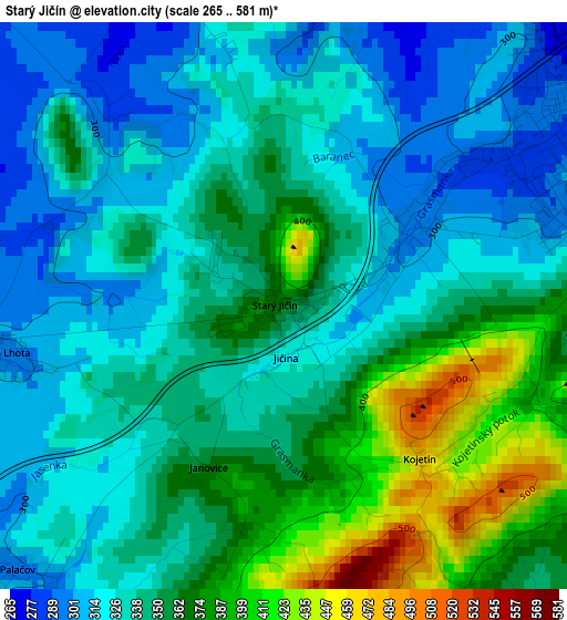
Below is the Elevation map of Starý Jičín, which displays elevation range with different colors. Scale of the first map is from 265 to 581 m (869 to 1906 ft) with average elevation of 345.5 meters (=1134 ft) [note 1]
These maps also provides idea of topography and contour of this city, they are displayed at different zoom levels. More info about maps, scale and edge coordinates you can find below images.
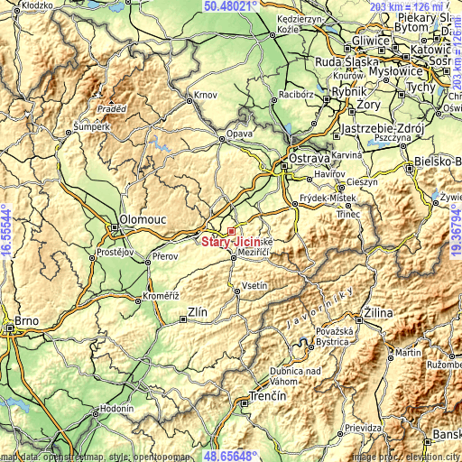
| \ | Map #1 | Topo.Map |
| Scale [m] | 265..581 m | × |
| Scale [ft] | 869..1906 ft | × |
| Average | 345.5 m = 1134 ft | × |
| Width | 6.34 km = 3.9 mi | 202.8 km = 126 mi |
| Height | 6.34 km = 3.9 mi | 202.8 km = 126 mi |
| ↑Max Latitude | 49.605347° | 50.48021° |
| Latitude at center | 49.57686° | 49.57686° |
| ↓Min Latitude | 49.548356° | 48.65648° |
| ← Min Longitude | 17.917745° | 16.55544° |
| Longitude center | 17.96169° | 17.96169° |
| →Max Longitude | 18.005635° | 19.36794° |
Nearby cities:
Cities around Starý Jičín sort by population:
• Valašské Meziříčí elevation 311 m
11.7 km,  176°
176°
• Nový Jičín 287 m
4 km,  60°
60°
• Štramberk 418 m
11.3 km,  81°
81°
• Vlčnov 342 m
0.6 km,  291°
291°
• Mořkov 361 m
8.4 km,  122°
122°
• Lešná 295 m
6.7 km,  200°
200°
• Jeseník nad Odrou 258 m
5.6 km,  313°
313°
• Kunín 251 m
6.6 km,  17°
17°
• Hustopeče Nad Bečvou 273 m
8.4 km,  232°
232°
• Hodslavice 339 m
6.2 km,  133°
133°
• Bělotín 294 m
11.3 km,  278°
278°
• Rybí 318 m
8.7 km,  72°
72°
Multilingual:
 En español:
Starý Jičín elevación 366 m.
 En France:
Starý Jičín élévation 366 m.
 Auf Deutsch:
Alttitschein höhe über dem Meeresspiegel ist 366 m.

Sources and notes:
- [note 1] Map square and city borders are not equal. Map elevation data is calculated only from area inside that square.
- [src 1] Elevation data from geonames database provided with same terms of usage.
- [src 2] The elevation map of Starý Jičín is generated using elevation data from NASA's 3 arcsec (90m) resolution SRTM data.
- [src 3] Base (background) map © OpenStreetMap contributors tiles are generated by Geofabrik and OpenTopoMap.
Copyright & License:
This Starý Jičín Elevation Map is licensed under CC BY-SA. You may reuse any part from this page, if you give a proper credit by linking to this URL:
 More info on terms of use page.